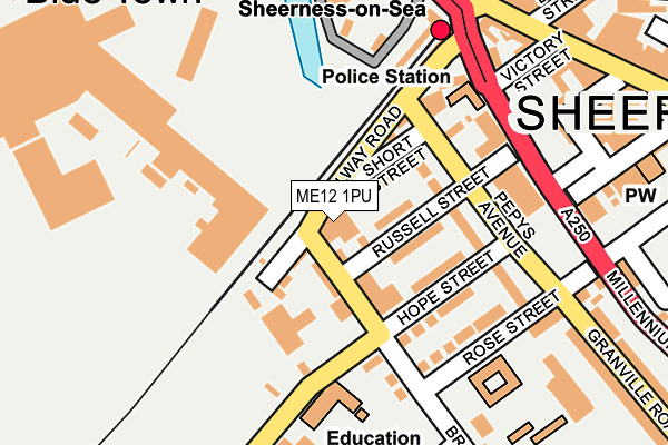
ME12 1PU is located in the Sheerness electoral ward, within the local authority district of Swale and the English Parliamentary constituency of Sittingbourne and Sheppey. The Sub Integrated Care Board (ICB) Location is NHS Kent and Medway ICB - 91Q and the police force is Kent. This postcode has been in use since June 1997.


GetTheData
Source: OS OpenMap – Local (Ordnance Survey)
Source: OS VectorMap District (Ordnance Survey)
Licence: Open Government Licence (requires attribution)
| Easting | 591719 |
| Northing | 174760 |
| Latitude | 51.439384 |
| Longitude | 0.757123 |
GetTheData
Source: Open Postcode Geo
Licence: Open Government Licence
| Country | England |
| Postcode District | ME12 |
| ➜ ME12 open data dashboard ➜ See where ME12 is on a map ➜ Where is Sheerness? | |
GetTheData
Source: Land Registry Price Paid Data
Licence: Open Government Licence
Elevation or altitude of ME12 1PU as distance above sea level:
| Metres | Feet | |
|---|---|---|
| Elevation | 0m | 0ft |
Elevation is measured from the approximate centre of the postcode, to the nearest point on an OS contour line from OS Terrain 50, which has contour spacing of ten vertical metres.
➜ How high above sea level am I? Find the elevation of your current position using your device's GPS.
GetTheData
Source: Open Postcode Elevation
Licence: Open Government Licence
| Ward | Sheerness |
| Constituency | Sittingbourne And Sheppey |
GetTheData
Source: ONS Postcode Database
Licence: Open Government Licence
| January 2024 | Shoplifting | On or near Broad Street | 171m |
| January 2024 | Anti-social behaviour | On or near High Street | 222m |
| January 2024 | Criminal damage and arson | On or near High Street | 222m |
| ➜ Get more crime data in our Crime section | |||
GetTheData
Source: data.police.uk
Licence: Open Government Licence
| Railway Station (Bridge Road) | Sheerness | 222m |
| Railway Station (Bridge Road) | Sheerness | 231m |
| Railway Station (Bridge Road) | Sheerness | 241m |
| Aldi (Millennium Way) | Sheerness | 265m |
| Aldi (Millennium Way) | Sheerness | 273m |
| Sheerness-on-Sea Station | 0.2km |
| Queenborough Station | 2.7km |
GetTheData
Source: NaPTAN
Licence: Open Government Licence
GetTheData
Source: ONS Postcode Database
Licence: Open Government Licence


➜ Get more ratings from the Food Standards Agency
GetTheData
Source: Food Standards Agency
Licence: FSA terms & conditions
| Last Collection | |||
|---|---|---|---|
| Location | Mon-Fri | Sat | Distance |
| Hope Street | 17:00 | 11:45 | 114m |
| Railway Station | 18:30 | 12:00 | 275m |
| Tesco | 18:30 | 11:45 | 439m |
GetTheData
Source: Dracos
Licence: Creative Commons Attribution-ShareAlike
| Facility | Distance |
|---|---|
| Inshape & Body Care (Closed) Railway Road, Sheerness Health and Fitness Gym, Studio | 0m |
| Rose Street Primary School Rose Street, Sheerness Grass Pitches | 191m |
| Festival Playing Field New Road, Sheerness Grass Pitches | 256m |
GetTheData
Source: Active Places
Licence: Open Government Licence
| School | Phase of Education | Distance |
|---|---|---|
| St Edward's Catholic Primary School New Road, Sheerness, ME12 1BW | Primary | 170m |
| Rose Street Primary School Rose Street, Sheerness, ME12 1AW | Primary | 200m |
| West Minster Primary School St George's Avenue, Sheerness, ME12 1ET | Primary | 913m |
GetTheData
Source: Edubase
Licence: Open Government Licence
| Risk of ME12 1PU flooding from rivers and sea | Low |
| ➜ ME12 1PU flood map | |
GetTheData
Source: Open Flood Risk by Postcode
Licence: Open Government Licence
The below table lists the International Territorial Level (ITL) codes (formerly Nomenclature of Territorial Units for Statistics (NUTS) codes) and Local Administrative Units (LAU) codes for ME12 1PU:
| ITL 1 Code | Name |
|---|---|
| TLJ | South East (England) |
| ITL 2 Code | Name |
| TLJ4 | Kent |
| ITL 3 Code | Name |
| TLJ43 | Kent Thames Gateway |
| LAU 1 Code | Name |
| E07000113 | Swale |
GetTheData
Source: ONS Postcode Directory
Licence: Open Government Licence
The below table lists the Census Output Area (OA), Lower Layer Super Output Area (LSOA), and Middle Layer Super Output Area (MSOA) for ME12 1PU:
| Code | Name | |
|---|---|---|
| OA | E00124918 | |
| LSOA | E01024614 | Swale 002B |
| MSOA | E02005116 | Swale 002 |
GetTheData
Source: ONS Postcode Directory
Licence: Open Government Licence
| ME12 1PP | Russell Street | 33m |
| ME12 1PY | Broad Street | 48m |
| ME12 1PX | Railway Road | 64m |
| ME12 1PT | Russell Street | 75m |
| ME12 1PG | Railway Road | 90m |
| ME12 1QD | Hope Street | 122m |
| ME12 1PF | Railway Road | 134m |
| ME12 1AL | Broad Street | 162m |
| ME12 1AW | Rose Street | 204m |
| ME12 1NZ | Victory Street | 232m |
GetTheData
Source: Open Postcode Geo; Land Registry Price Paid Data
Licence: Open Government Licence