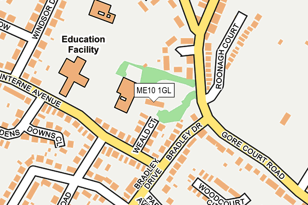
ME10 1GL is located in the Woodstock electoral ward, within the local authority district of Swale and the English Parliamentary constituency of Sittingbourne and Sheppey. The Sub Integrated Care Board (ICB) Location is NHS Kent and Medway ICB - 91Q and the police force is Kent. This postcode has been in use since December 1997.


GetTheData
Source: OS OpenMap – Local (Ordnance Survey)
Source: OS VectorMap District (Ordnance Survey)
Licence: Open Government Licence (requires attribution)
| Easting | 589981 |
| Northing | 162769 |
| Latitude | 51.332273 |
| Longitude | 0.725768 |
GetTheData
Source: Open Postcode Geo
Licence: Open Government Licence
| Country | England |
| Postcode District | ME10 |
| ➜ ME10 open data dashboard ➜ See where ME10 is on a map ➜ Where is Sittingbourne? | |
GetTheData
Source: Land Registry Price Paid Data
Licence: Open Government Licence
Elevation or altitude of ME10 1GL as distance above sea level:
| Metres | Feet | |
|---|---|---|
| Elevation | 30m | 98ft |
Elevation is measured from the approximate centre of the postcode, to the nearest point on an OS contour line from OS Terrain 50, which has contour spacing of ten vertical metres.
➜ How high above sea level am I? Find the elevation of your current position using your device's GPS.
GetTheData
Source: Open Postcode Elevation
Licence: Open Government Licence
| Ward | Woodstock |
| Constituency | Sittingbourne And Sheppey |
GetTheData
Source: ONS Postcode Database
Licence: Open Government Licence
| August 2023 | Public order | On or near Parking Area | 322m |
| August 2023 | Other theft | On or near Parking Area | 322m |
| August 2023 | Violence and sexual offences | On or near Parking Area | 322m |
| ➜ Get more crime data in our Crime section | |||
GetTheData
Source: data.police.uk
Licence: Open Government Licence
| Lyndhurst Grove (Gore Court Road) | Sittingbourne | 111m |
| Lyndhurst Grove (Gore Court Road) | Sittingbourne | 119m |
| Sterling Road | Sittingbourne | 236m |
| Windsor Drive (Minterne Avenue) | Sittingbourne | 282m |
| Homewood Avenue | Sittingbourne | 403m |
| Sittingbourne Station | 1.2km |
| Kemsley Station | 3.4km |
| Newington Station | 4.6km |
GetTheData
Source: NaPTAN
Licence: Open Government Licence
GetTheData
Source: ONS Postcode Database
Licence: Open Government Licence


➜ Get more ratings from the Food Standards Agency
GetTheData
Source: Food Standards Agency
Licence: FSA terms & conditions
| Last Collection | |||
|---|---|---|---|
| Location | Mon-Fri | Sat | Distance |
| Park Drive Upper | 17:30 | 12:00 | 224m |
| Park Drive Lower | 17:30 | 12:00 | 224m |
| Chaucer Road (Ex P O) | 17:15 | 12:00 | 306m |
GetTheData
Source: Dracos
Licence: Creative Commons Attribution-ShareAlike
| Facility | Distance |
|---|---|
| St Peter's Catholic Primary School West Ridge, Sittingbourne Grass Pitches | 209m |
| The Appleyard The Fieldings, Sittingbourne Grass Pitches, Outdoor Tennis Courts | 319m |
| King George V Playing Field (Sittingbourne) Park Avenue, Sittingbourne Grass Pitches, Outdoor Tennis Courts | 439m |
GetTheData
Source: Active Places
Licence: Open Government Licence
| School | Phase of Education | Distance |
|---|---|---|
| The Oaks Infant School Gore Court Road, Sittingbourne, ME10 1GL | Primary | 59m |
| Minterne Junior School Minterne Avenue, Sittingbourne, ME10 1SB | Primary | 171m |
| St Peter's Catholic Primary School West Ridge, Sittingbourne, ME10 1UJ | Primary | 209m |
GetTheData
Source: Edubase
Licence: Open Government Licence
The below table lists the International Territorial Level (ITL) codes (formerly Nomenclature of Territorial Units for Statistics (NUTS) codes) and Local Administrative Units (LAU) codes for ME10 1GL:
| ITL 1 Code | Name |
|---|---|
| TLJ | South East (England) |
| ITL 2 Code | Name |
| TLJ4 | Kent |
| ITL 3 Code | Name |
| TLJ43 | Kent Thames Gateway |
| LAU 1 Code | Name |
| E07000113 | Swale |
GetTheData
Source: ONS Postcode Directory
Licence: Open Government Licence
The below table lists the Census Output Area (OA), Lower Layer Super Output Area (LSOA), and Middle Layer Super Output Area (MSOA) for ME10 1GL:
| Code | Name | |
|---|---|---|
| OA | E00125012 | |
| LSOA | E01024630 | Swale 012D |
| MSOA | E02005126 | Swale 012 |
GetTheData
Source: ONS Postcode Directory
Licence: Open Government Licence
| ME10 1RY | Weald Court | 64m |
| ME10 1QL | Gore Court Road | 87m |
| ME10 1QH | Lyndhurst Grove | 105m |
| ME10 1RB | Bradley Drive | 121m |
| ME10 1SD | Minterne Avenue | 126m |
| ME10 1SA | Minterne Avenue | 157m |
| ME10 1EU | Ufton Lane | 164m |
| ME10 1RP | Roseleigh Road | 168m |
| ME10 1SQ | Fernleigh Terrace | 177m |
| ME10 1RN | Park Drive | 180m |
GetTheData
Source: Open Postcode Geo; Land Registry Price Paid Data
Licence: Open Government Licence