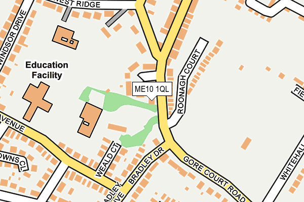
ME10 1QL lies on Gore Court Road in Sittingbourne. ME10 1QL is located in the Woodstock electoral ward, within the local authority district of Swale and the English Parliamentary constituency of Sittingbourne and Sheppey. The Sub Integrated Care Board (ICB) Location is NHS Kent and Medway ICB - 91Q and the police force is Kent. This postcode has been in use since January 1980.


GetTheData
Source: OS OpenMap – Local (Ordnance Survey)
Source: OS VectorMap District (Ordnance Survey)
Licence: Open Government Licence (requires attribution)
| Easting | 590051 |
| Northing | 162821 |
| Latitude | 51.332716 |
| Longitude | 0.726768 |
GetTheData
Source: Open Postcode Geo
Licence: Open Government Licence
| Street | Gore Court Road |
| Town/City | Sittingbourne |
| Country | England |
| Postcode District | ME10 |
➜ See where ME10 is on a map ➜ Where is Sittingbourne? | |
GetTheData
Source: Land Registry Price Paid Data
Licence: Open Government Licence
Elevation or altitude of ME10 1QL as distance above sea level:
| Metres | Feet | |
|---|---|---|
| Elevation | 30m | 98ft |
Elevation is measured from the approximate centre of the postcode, to the nearest point on an OS contour line from OS Terrain 50, which has contour spacing of ten vertical metres.
➜ How high above sea level am I? Find the elevation of your current position using your device's GPS.
GetTheData
Source: Open Postcode Elevation
Licence: Open Government Licence
| Ward | Woodstock |
| Constituency | Sittingbourne And Sheppey |
GetTheData
Source: ONS Postcode Database
Licence: Open Government Licence
6, GORE COURT ROAD, SITTINGBOURNE, ME10 1QL 2007 9 AUG £500,000 |
GetTheData
Source: HM Land Registry Price Paid Data
Licence: Contains HM Land Registry data © Crown copyright and database right 2025. This data is licensed under the Open Government Licence v3.0.
| Lyndhurst Grove (Gore Court Road) | Sittingbourne | 27m |
| Lyndhurst Grove (Gore Court Road) | Sittingbourne | 33m |
| Sterling Road | Sittingbourne | 323m |
| Homewood Avenue | Sittingbourne | 339m |
| Windsor Drive (Minterne Avenue) | Sittingbourne | 349m |
| Sittingbourne Station | 1.2km |
| Kemsley Station | 3.4km |
| Newington Station | 4.7km |
GetTheData
Source: NaPTAN
Licence: Open Government Licence
| Percentage of properties with Next Generation Access | 100.0% |
| Percentage of properties with Superfast Broadband | 100.0% |
| Percentage of properties with Ultrafast Broadband | 100.0% |
| Percentage of properties with Full Fibre Broadband | 0.0% |
Superfast Broadband is between 30Mbps and 300Mbps
Ultrafast Broadband is > 300Mbps
| Percentage of properties unable to receive 2Mbps | 0.0% |
| Percentage of properties unable to receive 5Mbps | 0.0% |
| Percentage of properties unable to receive 10Mbps | 0.0% |
| Percentage of properties unable to receive 30Mbps | 0.0% |
GetTheData
Source: Ofcom
Licence: Ofcom Terms of Use (requires attribution)
GetTheData
Source: ONS Postcode Database
Licence: Open Government Licence


➜ Get more ratings from the Food Standards Agency
GetTheData
Source: Food Standards Agency
Licence: FSA terms & conditions
| Last Collection | |||
|---|---|---|---|
| Location | Mon-Fri | Sat | Distance |
| Chaucer Road (Ex P O) | 17:15 | 12:00 | 278m |
| Park Drive Lower | 17:30 | 12:00 | 295m |
| Park Drive Upper | 17:30 | 12:00 | 295m |
GetTheData
Source: Dracos
Licence: Creative Commons Attribution-ShareAlike
The below table lists the International Territorial Level (ITL) codes (formerly Nomenclature of Territorial Units for Statistics (NUTS) codes) and Local Administrative Units (LAU) codes for ME10 1QL:
| ITL 1 Code | Name |
|---|---|
| TLJ | South East (England) |
| ITL 2 Code | Name |
| TLJ4 | Kent |
| ITL 3 Code | Name |
| TLJ43 | Kent Thames Gateway |
| LAU 1 Code | Name |
| E07000113 | Swale |
GetTheData
Source: ONS Postcode Directory
Licence: Open Government Licence
The below table lists the Census Output Area (OA), Lower Layer Super Output Area (LSOA), and Middle Layer Super Output Area (MSOA) for ME10 1QL:
| Code | Name | |
|---|---|---|
| OA | E00125011 | |
| LSOA | E01024630 | Swale 012D |
| MSOA | E02005126 | Swale 012 |
GetTheData
Source: ONS Postcode Directory
Licence: Open Government Licence
| ME10 1QH | Lyndhurst Grove | 70m |
| ME10 1QS | Roonagh Court | 99m |
| ME10 1EU | Ufton Lane | 107m |
| ME10 1RY | Weald Court | 136m |
| ME10 1RB | Bradley Drive | 164m |
| ME10 1ER | Park Road | 176m |
| ME10 1EP | Park Road | 193m |
| ME10 1UQ | West Ridge | 206m |
| ME10 1SD | Minterne Avenue | 209m |
| ME10 1QN | Gore Court Road | 212m |
GetTheData
Source: Open Postcode Geo; Land Registry Price Paid Data
Licence: Open Government Licence