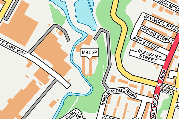
M9 5SP is located in the Harpurhey electoral ward, within the metropolitan district of Manchester and the English Parliamentary constituency of Blackley and Broughton. The Sub Integrated Care Board (ICB) Location is NHS Greater Manchester ICB - 14L and the police force is Greater Manchester. This postcode has been in use since June 1997.


GetTheData
Source: OS OpenMap – Local (Ordnance Survey)
Source: OS VectorMap District (Ordnance Survey)
Licence: Open Government Licence (requires attribution)
| Easting | 385456 |
| Northing | 401383 |
| Latitude | 53.508928 |
| Longitude | -2.220768 |
GetTheData
Source: Open Postcode Geo
Licence: Open Government Licence
| Country | England |
| Postcode District | M9 |
➜ See where M9 is on a map ➜ Where is Manchester? | |
GetTheData
Source: Land Registry Price Paid Data
Licence: Open Government Licence
Elevation or altitude of M9 5SP as distance above sea level:
| Metres | Feet | |
|---|---|---|
| Elevation | 40m | 131ft |
Elevation is measured from the approximate centre of the postcode, to the nearest point on an OS contour line from OS Terrain 50, which has contour spacing of ten vertical metres.
➜ How high above sea level am I? Find the elevation of your current position using your device's GPS.
GetTheData
Source: Open Postcode Elevation
Licence: Open Government Licence
| Ward | Harpurhey |
| Constituency | Blackley And Broughton |
GetTheData
Source: ONS Postcode Database
Licence: Open Government Licence
| Harpurhey Road | Harpurhey | 91m |
| Harpurhey Road | Harpurhey | 103m |
| Harpurhey Rd/Rochdale Rd (Harpurhey Rd) | Harpurhey | 191m |
| Harpurhey Rd/Rochdale Rd (Harpurhey Rd) | Harpurhey | 204m |
| Rochdale Rd/Pleasant St (Rochdale Rd) | Harpurhey | 254m |
| Woodlands Road (Manchester Metrolink) (Off Woodlands Road) | Cheetham Hill | 816m |
| Queens Road (Manchester Metrolink) (Queens Road) | Smedley | 895m |
| Abraham Moss (Manchester Metrolink) (Woodlands Road) | Cheetham Hill | 1,013m |
| Monsall (Manchester Metrolink) (Ruislip Avenue) | Monsall | 1,101m |
| Crumpsall (Manchester Metrolink) (Off Station Road) | Higher Crumpsall | 1,643m |
| Manchester Victoria Station | 2.8km |
| Manchester Piccadilly Station | 3.6km |
| Salford Central Station | 3.7km |
GetTheData
Source: NaPTAN
Licence: Open Government Licence
GetTheData
Source: ONS Postcode Database
Licence: Open Government Licence


➜ Get more ratings from the Food Standards Agency
GetTheData
Source: Food Standards Agency
Licence: FSA terms & conditions
| Last Collection | |||
|---|---|---|---|
| Location | Mon-Fri | Sat | Distance |
| Asda | 17:30 | 12:00 | 723m |
| Smedley Lane P.o. | 17:30 | 12:00 | 906m |
| Blackley Park | 17:30 | 11:45 | 1,019m |
GetTheData
Source: Dracos
Licence: Creative Commons Attribution-ShareAlike
| Risk of M9 5SP flooding from rivers and sea | Low |
| ➜ M9 5SP flood map | |
GetTheData
Source: Open Flood Risk by Postcode
Licence: Open Government Licence
The below table lists the International Territorial Level (ITL) codes (formerly Nomenclature of Territorial Units for Statistics (NUTS) codes) and Local Administrative Units (LAU) codes for M9 5SP:
| ITL 1 Code | Name |
|---|---|
| TLD | North West (England) |
| ITL 2 Code | Name |
| TLD3 | Greater Manchester |
| ITL 3 Code | Name |
| TLD33 | Manchester |
| LAU 1 Code | Name |
| E08000003 | Manchester |
GetTheData
Source: ONS Postcode Directory
Licence: Open Government Licence
The below table lists the Census Output Area (OA), Lower Layer Super Output Area (LSOA), and Middle Layer Super Output Area (MSOA) for M9 5SP:
| Code | Name | |
|---|---|---|
| OA | E00026362 | |
| LSOA | E01005203 | Manchester 009B |
| MSOA | E02001053 | Manchester 009 |
GetTheData
Source: ONS Postcode Directory
Licence: Open Government Licence
| M9 5SG | Delaware Walk | 180m |
| M9 5XZ | Cypress Street | 199m |
| M9 5XY | 217m | |
| M9 5XX | 249m | |
| M9 5SR | Kesteven Road | 264m |
| M9 5XJ | Baywood Street | 264m |
| M9 5XD | Rochdale Road | 285m |
| M9 5SS | Kesteven Road | 289m |
| M9 5UJ | Fernclough Road | 290m |
| M9 5XS | Beech Mount | 321m |
GetTheData
Source: Open Postcode Geo; Land Registry Price Paid Data
Licence: Open Government Licence