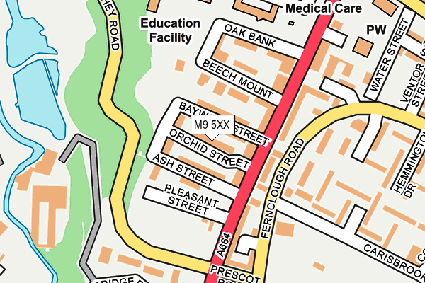
M9 5XX is in Prospect Road, Manchester. M9 5XX is located in the Harpurhey electoral ward, within the metropolitan district of Manchester and the English Parliamentary constituency of Blackley and Broughton. The Sub Integrated Care Board (ICB) Location is NHS Greater Manchester ICB - 14L and the police force is Greater Manchester. This postcode has been in use since May 1994.


GetTheData
Source: OS OpenMap – Local (Ordnance Survey)
Source: OS VectorMap District (Ordnance Survey)
Licence: Open Government Licence (requires attribution)
| Easting | 385686 |
| Northing | 401478 |
| Latitude | 53.509805 |
| Longitude | -2.217302 |
GetTheData
Source: Open Postcode Geo
Licence: Open Government Licence
| Locality | Prospect Road |
| Town/City | Manchester |
| Country | England |
| Postcode District | M9 |
➜ See where M9 is on a map ➜ Where is Manchester? | |
GetTheData
Source: Land Registry Price Paid Data
Licence: Open Government Licence
Elevation or altitude of M9 5XX as distance above sea level:
| Metres | Feet | |
|---|---|---|
| Elevation | 70m | 230ft |
Elevation is measured from the approximate centre of the postcode, to the nearest point on an OS contour line from OS Terrain 50, which has contour spacing of ten vertical metres.
➜ How high above sea level am I? Find the elevation of your current position using your device's GPS.
GetTheData
Source: Open Postcode Elevation
Licence: Open Government Licence
| Ward | Harpurhey |
| Constituency | Blackley And Broughton |
GetTheData
Source: ONS Postcode Database
Licence: Open Government Licence
| Rochdale Rd/Harpurhey Rd (Rochdale Rd) | Harpurhey | 88m |
| Rochdale Rd/Pleasant St (Rochdale Rd) | Harpurhey | 101m |
| Fernclough Way/Carisbrook St (Fernclough Rd) | Harpurhey | 113m |
| Fernclough Rd/Brewster St (Fernclough Rd) | Harpurhey | 139m |
| Harpurhey Road | Harpurhey | 149m |
| Woodlands Road (Manchester Metrolink) (Off Woodlands Road) | Cheetham Hill | 1,052m |
| Monsall (Manchester Metrolink) (Ruislip Avenue) | Monsall | 1,065m |
| Queens Road (Manchester Metrolink) (Queens Road) | Smedley | 1,094m |
| Abraham Moss (Manchester Metrolink) (Woodlands Road) | Cheetham Hill | 1,228m |
| Central Park (Manchester Metrolink) (The Gateway) | Newton Heath | 1,510m |
| Manchester Victoria Station | 3km |
| Moston Station | 3.4km |
| Manchester Piccadilly Station | 3.7km |
GetTheData
Source: NaPTAN
Licence: Open Government Licence
| Percentage of properties with Next Generation Access | 100.0% |
| Percentage of properties with Superfast Broadband | 100.0% |
| Percentage of properties with Ultrafast Broadband | 100.0% |
| Percentage of properties with Full Fibre Broadband | 0.0% |
Superfast Broadband is between 30Mbps and 300Mbps
Ultrafast Broadband is > 300Mbps
| Median download speed | 72.8Mbps |
| Average download speed | 89.8Mbps |
| Maximum download speed | 200.00Mbps |
| Median upload speed | 19.8Mbps |
| Average upload speed | 12.3Mbps |
| Maximum upload speed | 20.00Mbps |
| Percentage of properties unable to receive 2Mbps | 0.0% |
| Percentage of properties unable to receive 5Mbps | 0.0% |
| Percentage of properties unable to receive 10Mbps | 0.0% |
| Percentage of properties unable to receive 30Mbps | 0.0% |
GetTheData
Source: Ofcom
Licence: Ofcom Terms of Use (requires attribution)
Estimated total energy consumption in M9 5XX by fuel type, 2015.
| Consumption (kWh) | 198,407 |
|---|---|
| Meter count | 13 |
| Mean (kWh/meter) | 15,262 |
| Median (kWh/meter) | 12,931 |
| Consumption (kWh) | 33,125 |
|---|---|
| Meter count | 11 |
| Mean (kWh/meter) | 3,011 |
| Median (kWh/meter) | 2,279 |
GetTheData
Source: Postcode level gas estimates: 2015 (experimental)
Source: Postcode level electricity estimates: 2015 (experimental)
Licence: Open Government Licence
GetTheData
Source: ONS Postcode Database
Licence: Open Government Licence


➜ Get more ratings from the Food Standards Agency
GetTheData
Source: Food Standards Agency
Licence: FSA terms & conditions
| Last Collection | |||
|---|---|---|---|
| Location | Mon-Fri | Sat | Distance |
| Asda | 17:30 | 12:00 | 492m |
| Blackley Park | 17:30 | 11:45 | 839m |
| Smedley Lane P.o. | 17:30 | 12:00 | 1,114m |
GetTheData
Source: Dracos
Licence: Creative Commons Attribution-ShareAlike
The below table lists the International Territorial Level (ITL) codes (formerly Nomenclature of Territorial Units for Statistics (NUTS) codes) and Local Administrative Units (LAU) codes for M9 5XX:
| ITL 1 Code | Name |
|---|---|
| TLD | North West (England) |
| ITL 2 Code | Name |
| TLD3 | Greater Manchester |
| ITL 3 Code | Name |
| TLD33 | Manchester |
| LAU 1 Code | Name |
| E08000003 | Manchester |
GetTheData
Source: ONS Postcode Directory
Licence: Open Government Licence
The below table lists the Census Output Area (OA), Lower Layer Super Output Area (LSOA), and Middle Layer Super Output Area (MSOA) for M9 5XX:
| Code | Name | |
|---|---|---|
| OA | E00026362 | |
| LSOA | E01005203 | Manchester 009B |
| MSOA | E02001053 | Manchester 009 |
GetTheData
Source: ONS Postcode Directory
Licence: Open Government Licence
| M9 5XJ | Baywood Street | 20m |
| M9 5XY | 43m | |
| M9 5XD | Rochdale Road | 51m |
| M9 5XZ | Cypress Street | 59m |
| M9 5XS | Beech Mount | 80m |
| M9 5UJ | Fernclough Road | 139m |
| M9 5TT | Rochdale Road | 150m |
| M9 5TU | Fernclough Road | 152m |
| M9 5UP | Coniston Avenue | 198m |
| M9 5UT | Brewster Street | 198m |
GetTheData
Source: Open Postcode Geo; Land Registry Price Paid Data
Licence: Open Government Licence