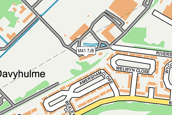
M41 7JB is located in the Davyhulme electoral ward, within the metropolitan district of Trafford and the English Parliamentary constituency of Stretford and Urmston. The Sub Integrated Care Board (ICB) Location is NHS Greater Manchester ICB - 02A and the police force is Greater Manchester. This postcode has been in use since May 1994.


GetTheData
Source: OS OpenMap – Local (Ordnance Survey)
Source: OS VectorMap District (Ordnance Survey)
Licence: Open Government Licence (requires attribution)
| Easting | 375845 |
| Northing | 396129 |
| Latitude | 53.461348 |
| Longitude | -2.365277 |
GetTheData
Source: Open Postcode Geo
Licence: Open Government Licence
| Country | England |
| Postcode District | M41 |
| ➜ M41 open data dashboard ➜ See where M41 is on a map ➜ Where is Urmston? | |
GetTheData
Source: Land Registry Price Paid Data
Licence: Open Government Licence
Elevation or altitude of M41 7JB as distance above sea level:
| Metres | Feet | |
|---|---|---|
| Elevation | 20m | 66ft |
Elevation is measured from the approximate centre of the postcode, to the nearest point on an OS contour line from OS Terrain 50, which has contour spacing of ten vertical metres.
➜ How high above sea level am I? Find the elevation of your current position using your device's GPS.
GetTheData
Source: Open Postcode Elevation
Licence: Open Government Licence
| Ward | Davyhulme |
| Constituency | Stretford And Urmston |
GetTheData
Source: ONS Postcode Database
Licence: Open Government Licence
| Broadway/Welwyn Close (Broadway) | Croft's Bank | 219m |
| Broadway/Welwyn Close (Broadway) | Croft's Bank | 224m |
| Broadway/Medical Ctr (Broadway) | Croft's Bank | 275m |
| Broadway/Medical Ctr (Broadway) | Croft's Bank | 278m |
| Neary Way/Trafford Retail Park (Neary Way) | Croft's Bank | 447m |
| Urmston Station | 1.6km |
| Chassen Road Station | 1.7km |
| Flixton Station | 2.3km |
GetTheData
Source: NaPTAN
Licence: Open Government Licence
GetTheData
Source: ONS Postcode Database
Licence: Open Government Licence

➜ Get more ratings from the Food Standards Agency
GetTheData
Source: Food Standards Agency
Licence: FSA terms & conditions
| Last Collection | |||
|---|---|---|---|
| Location | Mon-Fri | Sat | Distance |
| Amersham Close | 17:30 | 11:30 | 185m |
| Kingsway | 17:30 | 11:30 | 461m |
| 72 Daveyhulme Road | 17:30 | 11:30 | 497m |
GetTheData
Source: Dracos
Licence: Creative Commons Attribution-ShareAlike
| Facility | Distance |
|---|---|
| Broadway Park Broadway, Urmston, Manchester Grass Pitches | 332m |
| Trafford Golf Centre Old Park Lane, Manchester Golf | 707m |
| Chill Factor E Trafford Way, Urmston, Manchester Ski Slopes | 785m |
GetTheData
Source: Active Places
Licence: Open Government Licence
| School | Phase of Education | Distance |
|---|---|---|
| Woodhouse Primary School Nursery Road, Davyhulme, Urmston, Manchester, M41 7WW | Primary | 541m |
| Our Lady of the Rosary RC Primary School Davyhulme Road, Davyhulme, Urmston, Manchester, M41 7DS | Primary | 543m |
| St Mary's CofE Primary School Cornhill Rd, Davyhulme, Urmston, Manchester, M41 5TJ | Primary | 588m |
GetTheData
Source: Edubase
Licence: Open Government Licence
| Risk of M41 7JB flooding from rivers and sea | Low |
| ➜ M41 7JB flood map | |
GetTheData
Source: Open Flood Risk by Postcode
Licence: Open Government Licence
The below table lists the International Territorial Level (ITL) codes (formerly Nomenclature of Territorial Units for Statistics (NUTS) codes) and Local Administrative Units (LAU) codes for M41 7JB:
| ITL 1 Code | Name |
|---|---|
| TLD | North West (England) |
| ITL 2 Code | Name |
| TLD3 | Greater Manchester |
| ITL 3 Code | Name |
| TLD34 | Greater Manchester South West |
| LAU 1 Code | Name |
| E08000009 | Trafford |
GetTheData
Source: ONS Postcode Directory
Licence: Open Government Licence
The below table lists the Census Output Area (OA), Lower Layer Super Output Area (LSOA), and Middle Layer Super Output Area (MSOA) for M41 7JB:
| Code | Name | |
|---|---|---|
| OA | E00031031 | |
| LSOA | E01006123 | Trafford 005B |
| MSOA | E02001263 | Trafford 005 |
GetTheData
Source: ONS Postcode Directory
Licence: Open Government Licence
| M41 7WH | Amersham Close | 57m |
| M41 7NJ | Amersham Close | 121m |
| M41 7WE | Welwyn Close | 121m |
| M41 7WF | Broadway | 140m |
| M41 7NH | Bexley Close | 203m |
| M41 7NF | Welwyn Close | 218m |
| M41 7WJ | Broadway | 230m |
| M41 7NR | Broadway Close | 244m |
| M41 7WD | Wycombe Close | 272m |
| M41 7NE | Broadway | 282m |
GetTheData
Source: Open Postcode Geo; Land Registry Price Paid Data
Licence: Open Government Licence