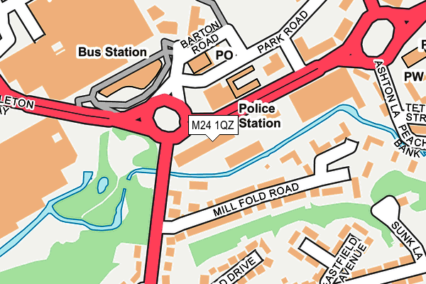
M24 1QZ is located in the East Middleton electoral ward, within the metropolitan district of Rochdale and the English Parliamentary constituency of Heywood and Middleton. The Sub Integrated Care Board (ICB) Location is NHS Greater Manchester ICB - 01D and the police force is Greater Manchester. This postcode has been in use since December 1995.


GetTheData
Source: OS OpenMap – Local (Ordnance Survey)
Source: OS VectorMap District (Ordnance Survey)
Licence: Open Government Licence (requires attribution)
| Easting | 386951 |
| Northing | 405607 |
| Latitude | 53.546935 |
| Longitude | -2.198404 |
GetTheData
Source: Open Postcode Geo
Licence: Open Government Licence
| Country | England |
| Postcode District | M24 |
| ➜ M24 open data dashboard ➜ See where M24 is on a map ➜ Where is Middleton? | |
GetTheData
Source: Land Registry Price Paid Data
Licence: Open Government Licence
Elevation or altitude of M24 1QZ as distance above sea level:
| Metres | Feet | |
|---|---|---|
| Elevation | 80m | 262ft |
Elevation is measured from the approximate centre of the postcode, to the nearest point on an OS contour line from OS Terrain 50, which has contour spacing of ten vertical metres.
➜ How high above sea level am I? Find the elevation of your current position using your device's GPS.
GetTheData
Source: Open Postcode Elevation
Licence: Open Government Licence
| Ward | East Middleton |
| Constituency | Heywood And Middleton |
GetTheData
Source: ONS Postcode Database
Licence: Open Government Licence
| Middleton Bus Station (Bus Station) | Middleton | 123m |
| Manchester New Rd/Mill Fold Rd (M/Cr New Rd) | Middleton | 126m |
| Manchester New Rd/Mill Fold Rd (M/Cr New Road) | Middleton | 140m |
| Manchester New Rd/Mount Rd (M/Cr New Rd) | Alkrington | 318m |
| Assheton Way/Long St (Assheton Way) | Middleton | 331m |
| Mills Hill (Manchester) Station | 1.8km |
| Moston Station | 3.2km |
| Castleton (Manchester) Station | 5.2km |
GetTheData
Source: NaPTAN
Licence: Open Government Licence
Estimated total energy consumption in M24 1QZ by fuel type, 2015.
| Consumption (kWh) | 179,887 |
|---|---|
| Meter count | 8 |
| Mean (kWh/meter) | 22,486 |
| Median (kWh/meter) | 18,672 |
GetTheData
Source: Postcode level gas estimates: 2015 (experimental)
Source: Postcode level electricity estimates: 2015 (experimental)
Licence: Open Government Licence
GetTheData
Source: ONS Postcode Database
Licence: Open Government Licence


➜ Get more ratings from the Food Standards Agency
GetTheData
Source: Food Standards Agency
Licence: FSA terms & conditions
| Last Collection | |||
|---|---|---|---|
| Location | Mon-Fri | Sat | Distance |
| Middleton P.o. | 18:00 | 12:00 | 107m |
| Dusty Millar | 17:30 | 12:00 | 225m |
| 123 Oldham Road | 17:30 | 12:00 | 438m |
GetTheData
Source: Dracos
Licence: Creative Commons Attribution-ShareAlike
| Facility | Distance |
|---|---|
| Jd Gyms (Middleton) Middleton Shopping Centre, Middleton, Manchester Health and Fitness Gym | 228m |
| Middleton Leisure Centre (Middleton) (Closed) Suffield Street, Middleton, Manchester Sports Hall, Studio, Swimming Pool, Health and Fitness Gym, Squash Courts | 250m |
| Middleton Arena Lance Corporal Joel Halliwell V C Way, Middleton, Manchester Health and Fitness Gym, Swimming Pool, Sports Hall, Studio, Squash Courts | 352m |
GetTheData
Source: Active Places
Licence: Open Government Licence
| School | Phase of Education | Distance |
|---|---|---|
| St Peter's Roman Catholic Primary School, Rochdale Kirkway, Middleton, Manchester, M24 1FL | Primary | 521m |
| Parkfield Primary School Harold Street, Middleton, Manchester, M24 4AF | Primary | 670m |
| Sunny Brow Nursery School Sunny Brow Road, Archer Park, Middleton, Manchester, M24 4AD | Nursery | 673m |
GetTheData
Source: Edubase
Licence: Open Government Licence
| Risk of M24 1QZ flooding from rivers and sea | Low |
| ➜ M24 1QZ flood map | |
GetTheData
Source: Open Flood Risk by Postcode
Licence: Open Government Licence
The below table lists the International Territorial Level (ITL) codes (formerly Nomenclature of Territorial Units for Statistics (NUTS) codes) and Local Administrative Units (LAU) codes for M24 1QZ:
| ITL 1 Code | Name |
|---|---|
| TLD | North West (England) |
| ITL 2 Code | Name |
| TLD3 | Greater Manchester |
| ITL 3 Code | Name |
| TLD37 | Greater Manchester North East |
| LAU 1 Code | Name |
| E08000005 | Rochdale |
GetTheData
Source: ONS Postcode Directory
Licence: Open Government Licence
The below table lists the Census Output Area (OA), Lower Layer Super Output Area (LSOA), and Middle Layer Super Output Area (MSOA) for M24 1QZ:
| Code | Name | |
|---|---|---|
| OA | E00028018 | |
| LSOA | E01005533 | Rochdale 024A |
| MSOA | E02001155 | Rochdale 024 |
GetTheData
Source: ONS Postcode Directory
Licence: Open Government Licence
| M24 1QJ | Silk Mill Way | 68m |
| M24 1AZ | Oldham Road | 85m |
| M24 1DF | Mill Fold Road | 112m |
| M24 1LU | Whitecroft Meadow | 146m |
| M24 1DE | Manchester New Road | 164m |
| M24 1AB | Middleton Gardens | 173m |
| M24 1DJ | Highfield Drive | 202m |
| M24 1DB | Westfield Avenue | 204m |
| M24 4DE | Manchester New Road | 215m |
| M24 1DP | Eastfield Avenue | 228m |
GetTheData
Source: Open Postcode Geo; Land Registry Price Paid Data
Licence: Open Government Licence