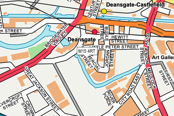
M15 4RT is located in the Deansgate electoral ward, within the metropolitan district of Manchester and the English Parliamentary constituency of Manchester Central. The Sub Integrated Care Board (ICB) Location is NHS Greater Manchester ICB - 14L and the police force is Greater Manchester. This postcode has been in use since September 2016.


GetTheData
Source: OS OpenMap – Local (Ordnance Survey)
Source: OS VectorMap District (Ordnance Survey)
Licence: Open Government Licence (requires attribution)
| Easting | 383415 |
| Northing | 397422 |
| Latitude | 53.473281 |
| Longitude | -2.251330 |
GetTheData
Source: Open Postcode Geo
Licence: Open Government Licence
| Country | England |
| Postcode District | M15 |
| ➜ M15 open data dashboard ➜ See where M15 is on a map | |
GetTheData
Source: Land Registry Price Paid Data
Licence: Open Government Licence
Elevation or altitude of M15 4RT as distance above sea level:
| Metres | Feet | |
|---|---|---|
| Elevation | 30m | 98ft |
Elevation is measured from the approximate centre of the postcode, to the nearest point on an OS contour line from OS Terrain 50, which has contour spacing of ten vertical metres.
➜ How high above sea level am I? Find the elevation of your current position using your device's GPS.
GetTheData
Source: Open Postcode Elevation
Licence: Open Government Licence
| Ward | Deansgate |
| Constituency | Manchester Central |
GetTheData
Source: ONS Postcode Database
Licence: Open Government Licence
| April 2022 | Violence and sexual offences | On or near Trafford Street | 207m |
| March 2022 | Violence and sexual offences | On or near Watson Street | 428m |
| ➜ Get more crime data in our Crime section | |||
GetTheData
Source: data.police.uk
Licence: Open Government Licence
| Bridgewater Viaduct/Knott Mill (Bridgewater Via) | Manchester City Centre | 109m |
| Deansgate Stn (Whitworth St W) | Manchester City Centre | 121m |
| Deansgate Stn (Whitworth St W) | Manchester City Centre | 140m |
| Deansgate/Deansgate Stn (Deansgate) | Manchester City Centre | 189m |
| Whitworth St West/Hacienda (Whitworth St W) | Manchester City Centre | 190m |
| Deansgate-castlefield (Manchester Metrolink) (Whitworth Street West) | Manchester City Centre | 165m |
| St Peters Square (Manchester Metrolink) (Peter Street) | Manchester City Centre | 774m |
| Cornbrook (Manchester Metrolink) | Cornbrook | 1,142m |
| Piccadilly Gardens (Manchester Metrolink) (Portland Street) | Piccadilly Gardens | 1,238m |
| Market Street (Manchester Metrolink) (Market Street) | Manchester City Centre | 1,259m |
| Deansgate Station | 0.1km |
| Manchester Oxford Road Station | 0.6km |
| Salford Central Station | 1.1km |
GetTheData
Source: NaPTAN
Licence: Open Government Licence
GetTheData
Source: ONS Postcode Database
Licence: Open Government Licence
➜ Get more ratings from the Food Standards Agency
GetTheData
Source: Food Standards Agency
Licence: FSA terms & conditions
| Last Collection | |||
|---|---|---|---|
| Location | Mon-Fri | Sat | Distance |
| Knott Mill Station, Junction | 19:00 | 12:00 | 138m |
| City Road East | 17:30 | 12:00 | 184m |
| Carnbrook Street | 17:30 | 11:45 | 283m |
GetTheData
Source: Dracos
Licence: Creative Commons Attribution-ShareAlike
| Facility | Distance |
|---|---|
| Livingwell Health Club (Manchester Deansgate) Deansgate, Manchester Health and Fitness Gym, Swimming Pool | 241m |
| Puregym (Manchester First Street) First Street, Manchester Health and Fitness Gym | 267m |
| Hulme Park Jackson Crescent, Manchester Grass Pitches | 418m |
GetTheData
Source: Active Places
Licence: Open Government Licence
| School | Phase of Education | Distance |
|---|---|---|
| St Wilfrid's RC Primary School Birchvale Close, Hulme, M15 5BJ | Primary | 510m |
| St Philip's Church of England Primary School Loxford Street, Hulme, Manchester, M15 6BT | Primary | 640m |
| The Manchester Metropolitan University All Saints Building, Oxford Road, Manchester, M15 6BH | Not applicable | 836m |
GetTheData
Source: Edubase
Licence: Open Government Licence
| Risk of M15 4RT flooding from rivers and sea | Medium |
| ➜ M15 4RT flood map | |
GetTheData
Source: Open Flood Risk by Postcode
Licence: Open Government Licence
The below table lists the International Territorial Level (ITL) codes (formerly Nomenclature of Territorial Units for Statistics (NUTS) codes) and Local Administrative Units (LAU) codes for M15 4RT:
| ITL 1 Code | Name |
|---|---|
| TLD | North West (England) |
| ITL 2 Code | Name |
| TLD3 | Greater Manchester |
| ITL 3 Code | Name |
| TLD33 | Manchester |
| LAU 1 Code | Name |
| E08000003 | Manchester |
GetTheData
Source: ONS Postcode Directory
Licence: Open Government Licence
The below table lists the Census Output Area (OA), Lower Layer Super Output Area (LSOA), and Middle Layer Super Output Area (MSOA) for M15 4RT:
| Code | Name | |
|---|---|---|
| OA | E00175997 | |
| LSOA | E01033683 | Manchester 060D |
| MSOA | E02006917 | Manchester 060 |
GetTheData
Source: ONS Postcode Directory
Licence: Open Government Licence
| M15 4RQ | Commercial Street | 0m |
| M15 4JQ | Constance Street | 37m |
| M15 4PY | Jordan Street | 50m |
| M15 4PS | Little Peter Street | 59m |
| M3 4LG | Deansgate | 62m |
| M3 4LA | Deansgate | 67m |
| M15 4QW | Commercial Street | 76m |
| M15 4QY | Commercial Street | 76m |
| M15 4QU | Jordan Street | 88m |
| M15 4QX | Jordan Street | 88m |
GetTheData
Source: Open Postcode Geo; Land Registry Price Paid Data
Licence: Open Government Licence