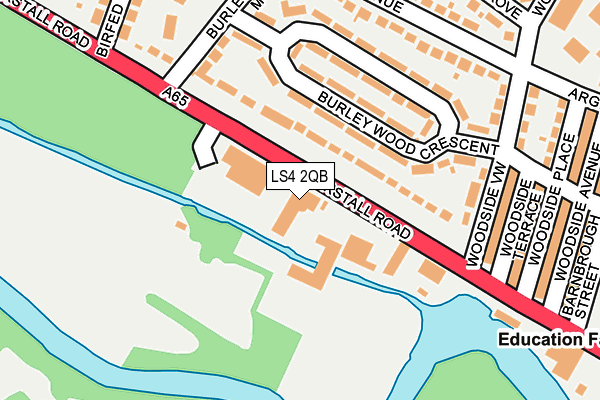
LS4 2QB is located in the Kirkstall electoral ward, within the metropolitan district of Leeds and the English Parliamentary constituency of Leeds West. The Sub Integrated Care Board (ICB) Location is NHS West Yorkshire ICB - 15F and the police force is West Yorkshire. This postcode has been in use since December 1995.


GetTheData
Source: OS OpenMap – Local (Ordnance Survey)
Source: OS VectorMap District (Ordnance Survey)
Licence: Open Government Licence (requires attribution)
| Easting | 426958 |
| Northing | 434860 |
| Latitude | 53.809337 |
| Longitude | -1.592100 |
GetTheData
Source: Open Postcode Geo
Licence: Open Government Licence
| Country | England |
| Postcode District | LS4 |
| ➜ LS4 open data dashboard ➜ See where LS4 is on a map ➜ Where is Leeds? | |
GetTheData
Source: Land Registry Price Paid Data
Licence: Open Government Licence
Elevation or altitude of LS4 2QB as distance above sea level:
| Metres | Feet | |
|---|---|---|
| Elevation | 40m | 131ft |
Elevation is measured from the approximate centre of the postcode, to the nearest point on an OS contour line from OS Terrain 50, which has contour spacing of ten vertical metres.
➜ How high above sea level am I? Find the elevation of your current position using your device's GPS.
GetTheData
Source: Open Postcode Elevation
Licence: Open Government Licence
| Ward | Kirkstall |
| Constituency | Leeds West |
GetTheData
Source: ONS Postcode Database
Licence: Open Government Licence
| November 2023 | Violence and sexual offences | On or near Adwick Place | 345m |
| October 2023 | Violence and sexual offences | On or near Adwick Place | 345m |
| September 2023 | Other theft | On or near Adwick Place | 345m |
| ➜ Get more crime data in our Crime section | |||
GetTheData
Source: data.police.uk
Licence: Open Government Licence
| Kirkstall Road Woodside View (Kirkstall Road) | Burley | 26m |
| Kirkstall Road Woodside View (Kirkstall Road) | Burley | 98m |
| Kirkstall Road Birfed Cres (Kirkstall Road) | Burley | 212m |
| Kirkstall Road Birfed Cres (Kirkstall Road) | Burley | 254m |
| Kirkstall Rd Argie Road (Kirkstall Road) | Burley | 382m |
| Headingley Station | 1km |
| Burley Park Station | 1km |
| Kirkstall Forge Station | 2.6km |
GetTheData
Source: NaPTAN
Licence: Open Government Licence
GetTheData
Source: ONS Postcode Database
Licence: Open Government Licence


➜ Get more ratings from the Food Standards Agency
GetTheData
Source: Food Standards Agency
Licence: FSA terms & conditions
| Last Collection | |||
|---|---|---|---|
| Location | Mon-Fri | Sat | Distance |
| Woodside View | 17:30 | 11:30 | 174m |
| St Anns Lane P.o. | 17:30 | 11:45 | 477m |
| 331 Burley Rd/Argie Avenue | 17:30 | 10:45 | 536m |
GetTheData
Source: Dracos
Licence: Creative Commons Attribution-ShareAlike
| Facility | Distance |
|---|---|
| City Golf Leeds Redcote Lane, Redcote Lane, Burley, Leeds Golf | 313m |
| Ck Fitness (Closed) Kirkstall Road, Leeds Sports Hall, Health and Fitness Gym | 355m |
| Sacred Heart Catholic Primary School Eden Way, Leeds Grass Pitches | 366m |
GetTheData
Source: Active Places
Licence: Open Government Licence
| School | Phase of Education | Distance |
|---|---|---|
| Kirkstall Valley Primary School Argie Road, Leeds, LS4 2QZ | Primary | 350m |
| Sacred Heart Catholic Primary School, a Voluntary Academy Eden Way, Argie Avenue, Leeds, LS4 2TF | Primary | 366m |
| Beecroft Primary School Eden Way, Leeds, LS4 2TF | Primary | 421m |
GetTheData
Source: Edubase
Licence: Open Government Licence
| Risk of LS4 2QB flooding from rivers and sea | Medium |
| ➜ LS4 2QB flood map | |
GetTheData
Source: Open Flood Risk by Postcode
Licence: Open Government Licence
The below table lists the International Territorial Level (ITL) codes (formerly Nomenclature of Territorial Units for Statistics (NUTS) codes) and Local Administrative Units (LAU) codes for LS4 2QB:
| ITL 1 Code | Name |
|---|---|
| TLE | Yorkshire and The Humber |
| ITL 2 Code | Name |
| TLE4 | West Yorkshire |
| ITL 3 Code | Name |
| TLE42 | Leeds |
| LAU 1 Code | Name |
| E08000035 | Leeds |
GetTheData
Source: ONS Postcode Directory
Licence: Open Government Licence
The below table lists the Census Output Area (OA), Lower Layer Super Output Area (LSOA), and Middle Layer Super Output Area (MSOA) for LS4 2QB:
| Code | Name | |
|---|---|---|
| OA | E00057899 | |
| LSOA | E01011482 | Leeds 056D |
| MSOA | E02002385 | Leeds 056 |
GetTheData
Source: ONS Postcode Directory
Licence: Open Government Licence
| LS4 2QD | Kirkstall Road | 62m |
| LS4 2QQ | Burley Wood Crescent | 86m |
| LS4 2QH | Burley Wood Crescent | 117m |
| LS4 2QL | Burley Wood Crescent | 139m |
| LS4 2QJ | Burley Wood Crescent | 167m |
| LS4 2QG | Burley Wood Mount | 179m |
| LS4 2QN | Argie Avenue | 196m |
| LS4 2QT | Woodside Terrace | 205m |
| LS4 2QS | Woodside View | 211m |
| LS4 2QR | Argie Avenue | 234m |
GetTheData
Source: Open Postcode Geo; Land Registry Price Paid Data
Licence: Open Government Licence