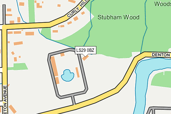
LS29 0BZ is located in the Ilkley electoral ward, within the metropolitan district of Bradford and the English Parliamentary constituency of Keighley. The Sub Integrated Care Board (ICB) Location is NHS West Yorkshire ICB - 36J and the police force is West Yorkshire. This postcode has been in use since January 1980.


GetTheData
Source: OS OpenMap – Local (Ordnance Survey)
Source: OS VectorMap District (Ordnance Survey)
Licence: Open Government Licence (requires attribution)
| Easting | 411860 |
| Northing | 448463 |
| Latitude | 53.932172 |
| Longitude | -1.820857 |
GetTheData
Source: Open Postcode Geo
Licence: Open Government Licence
| Country | England |
| Postcode District | LS29 |
| ➜ LS29 open data dashboard ➜ See where LS29 is on a map ➜ Where is Ilkley? | |
GetTheData
Source: Land Registry Price Paid Data
Licence: Open Government Licence
Elevation or altitude of LS29 0BZ as distance above sea level:
| Metres | Feet | |
|---|---|---|
| Elevation | 80m | 262ft |
Elevation is measured from the approximate centre of the postcode, to the nearest point on an OS contour line from OS Terrain 50, which has contour spacing of ten vertical metres.
➜ How high above sea level am I? Find the elevation of your current position using your device's GPS.
GetTheData
Source: Open Postcode Elevation
Licence: Open Government Licence
| Ward | Ilkley |
| Constituency | Keighley |
GetTheData
Source: ONS Postcode Database
Licence: Open Government Licence
| June 2022 | Anti-social behaviour | On or near Sports/Recreation Area | 127m |
| June 2022 | Drugs | On or near Sports/Recreation Area | 127m |
| June 2022 | Vehicle crime | On or near Sports/Recreation Area | 127m |
| ➜ Get more crime data in our Crime section | |||
GetTheData
Source: data.police.uk
Licence: Open Government Licence
| Rupert Road Gilstead Wy (Rupert Road) | Ilkley | 414m |
| Denton Road | Ilkley | 426m |
| Leeds Rd Thwaites Avenue (Leeds Road) | Ilkley | 511m |
| Leeds Rd Thwaites Avenue (Leeds Road) | Ilkley | 543m |
| Leeds Rd Lower Wellington Road (Leeds Road) | Ilkley | 550m |
| Ilkley Station | 0.8km |
| Ben Rhydding Station | 1.7km |
| Burley-in-Wharfedale Station | 5.2km |
GetTheData
Source: NaPTAN
Licence: Open Government Licence
GetTheData
Source: ONS Postcode Database
Licence: Open Government Licence


➜ Get more ratings from the Food Standards Agency
GetTheData
Source: Food Standards Agency
Licence: FSA terms & conditions
| Last Collection | |||
|---|---|---|---|
| Location | Mon-Fri | Sat | Distance |
| 138 Curley Hill | 16:00 | 10:15 | 188m |
| Denton Road/Middleton Avenue | 17:30 | 10:15 | 257m |
| Leeds Road P.o. | 17:45 | 12:00 | 590m |
GetTheData
Source: Dracos
Licence: Creative Commons Attribution-ShareAlike
| Facility | Distance |
|---|---|
| Ilkley Swimming Pool Denton Road, Ilkley Swimming Pool, Outdoor Tennis Courts | 0m |
| Olicanian Cricket Club Denton Road, Ilkley Grass Pitches | 117m |
| Ilkley Cricket Club Middleton Avenue, Ilkley Grass Pitches | 142m |
GetTheData
Source: Active Places
Licence: Open Government Licence
| School | Phase of Education | Distance |
|---|---|---|
| Ashlands Primary School Leeds Road, Ilkley, LS29 8JY | Primary | 647m |
| The Sacred Heart Catholic Primary School Valley Drive, Ben Rhydding, Ilkley, LS29 8NL | Primary | 886m |
| All Saints' CofE Primary School Easby Drive, Ilkley, LS29 9BE | Primary | 942m |
GetTheData
Source: Edubase
Licence: Open Government Licence
| Risk of LS29 0BZ flooding from rivers and sea | Medium |
| ➜ LS29 0BZ flood map | |
GetTheData
Source: Open Flood Risk by Postcode
Licence: Open Government Licence
The below table lists the International Territorial Level (ITL) codes (formerly Nomenclature of Territorial Units for Statistics (NUTS) codes) and Local Administrative Units (LAU) codes for LS29 0BZ:
| ITL 1 Code | Name |
|---|---|
| TLE | Yorkshire and The Humber |
| ITL 2 Code | Name |
| TLE4 | West Yorkshire |
| ITL 3 Code | Name |
| TLE41 | Bradford |
| LAU 1 Code | Name |
| E08000032 | Bradford |
GetTheData
Source: ONS Postcode Directory
Licence: Open Government Licence
The below table lists the Census Output Area (OA), Lower Layer Super Output Area (LSOA), and Middle Layer Super Output Area (MSOA) for LS29 0BZ:
| Code | Name | |
|---|---|---|
| OA | E00053939 | |
| LSOA | E01010694 | Bradford 002C |
| MSOA | E02002184 | Bradford 002 |
GetTheData
Source: ONS Postcode Directory
Licence: Open Government Licence
| LS29 0AH | Middleton Avenue | 156m |
| LS29 0BA | Curly Hill | 226m |
| LS29 0AD | Middleton Avenue | 227m |
| LS29 0DB | Gilstead Way | 297m |
| LS29 0AE | Gilstead Way | 301m |
| LS29 0AJ | Low Close | 304m |
| LS29 0AY | Curly Hill | 386m |
| LS29 0AQ | Rupert Road | 387m |
| LS29 0AG | Lakeside Close | 404m |
| LS29 8ER | Rivadale View | 404m |
GetTheData
Source: Open Postcode Geo; Land Registry Price Paid Data
Licence: Open Government Licence