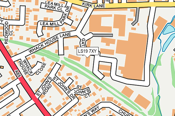
LS19 7XY is located in the Guiseley & Rawdon electoral ward, within the metropolitan district of Leeds and the English Parliamentary constituency of Pudsey. The Sub Integrated Care Board (ICB) Location is NHS West Yorkshire ICB - 15F and the police force is West Yorkshire. This postcode has been in use since January 1993.


GetTheData
Source: OS OpenMap – Local (Ordnance Survey)
Source: OS VectorMap District (Ordnance Survey)
Licence: Open Government Licence (requires attribution)
| Easting | 420252 |
| Northing | 440947 |
| Latitude | 53.864348 |
| Longitude | -1.693536 |
GetTheData
Source: Open Postcode Geo
Licence: Open Government Licence
| Country | England |
| Postcode District | LS19 |
| ➜ LS19 open data dashboard ➜ See where LS19 is on a map ➜ Where is Yeadon? | |
GetTheData
Source: Land Registry Price Paid Data
Licence: Open Government Licence
Elevation or altitude of LS19 7XY as distance above sea level:
| Metres | Feet | |
|---|---|---|
| Elevation | 150m | 492ft |
Elevation is measured from the approximate centre of the postcode, to the nearest point on an OS contour line from OS Terrain 50, which has contour spacing of ten vertical metres.
➜ How high above sea level am I? Find the elevation of your current position using your device's GPS.
GetTheData
Source: Open Postcode Elevation
Licence: Open Government Licence
| Ward | Guiseley & Rawdon |
| Constituency | Pudsey |
GetTheData
Source: ONS Postcode Database
Licence: Open Government Licence
| June 2022 | Other theft | On or near Park Road | 206m |
| June 2022 | Violence and sexual offences | On or near New Road | 234m |
| June 2022 | Violence and sexual offences | On or near New Road | 234m |
| ➜ Get more crime data in our Crime section | |||
GetTheData
Source: data.police.uk
Licence: Open Government Licence
| Kirk Lane Swaine Hill Ter (Kirk Lane) | Yeadon | 178m |
| Kirk Lane Swaine Hill Ter (Kirk Lane) | Yeadon | 208m |
| New Rd Westfield Avenue (New Road) | Westfield | 239m |
| New Rd Westfield Avenue (New Road) | Westfield | 240m |
| Kirk Lane | Yeadon | 254m |
| Guiseley Station | 1.9km |
| Apperley Bridge Station | 2.6km |
| Menston Station | 4.2km |
GetTheData
Source: NaPTAN
Licence: Open Government Licence
Estimated total energy consumption in LS19 7XY by fuel type, 2015.
| Consumption (kWh) | 290,045 |
|---|---|
| Meter count | 9 |
| Mean (kWh/meter) | 32,227 |
| Median (kWh/meter) | 32,559 |
GetTheData
Source: Postcode level gas estimates: 2015 (experimental)
Source: Postcode level electricity estimates: 2015 (experimental)
Licence: Open Government Licence
GetTheData
Source: ONS Postcode Database
Licence: Open Government Licence


➜ Get more ratings from the Food Standards Agency
GetTheData
Source: Food Standards Agency
Licence: FSA terms & conditions
| Last Collection | |||
|---|---|---|---|
| Location | Mon-Fri | Sat | Distance |
| Kirk Lane P.o. | 17:15 | 12:00 | 188m |
| Royal Mail Aireborough | 17:15 | 12:30 | 206m |
| Westfield Avenue | 17:30 | 12:30 | 238m |
GetTheData
Source: Dracos
Licence: Creative Commons Attribution-ShareAlike
| Facility | Distance |
|---|---|
| New Era Fitness Kirk Lane, Yeadon, Leeds Health and Fitness Gym | 123m |
| Yeadon Westfield Junior School New Road, Yeadon, Leeds Grass Pitches | 342m |
| Ss Peter & Paul Catholic Primary School New Road, Yeadon, Leeds Grass Pitches | 442m |
GetTheData
Source: Active Places
Licence: Open Government Licence
| School | Phase of Education | Distance |
|---|---|---|
| Yeadon Westfield Junior School New Road, Yeadon, Leeds, LS19 7HW | Primary | 342m |
| Ss. Peter and Paul Catholic Primary School, a Voluntary Academy Crofters Lea, Off New Road, Yeadon, Leeds, LS19 7HW | Primary | 342m |
| Yeadon Westfield Infant School Westfield Grove, Yeadon, Leeds, LS19 7NQ | Primary | 531m |
GetTheData
Source: Edubase
Licence: Open Government Licence
The below table lists the International Territorial Level (ITL) codes (formerly Nomenclature of Territorial Units for Statistics (NUTS) codes) and Local Administrative Units (LAU) codes for LS19 7XY:
| ITL 1 Code | Name |
|---|---|
| TLE | Yorkshire and The Humber |
| ITL 2 Code | Name |
| TLE4 | West Yorkshire |
| ITL 3 Code | Name |
| TLE42 | Leeds |
| LAU 1 Code | Name |
| E08000035 | Leeds |
GetTheData
Source: ONS Postcode Directory
Licence: Open Government Licence
The below table lists the Census Output Area (OA), Lower Layer Super Output Area (LSOA), and Middle Layer Super Output Area (MSOA) for LS19 7XY:
| Code | Name | |
|---|---|---|
| OA | E00056821 | |
| LSOA | E01011275 | Leeds 010D |
| MSOA | E02002339 | Leeds 010 |
GetTheData
Source: ONS Postcode Directory
Licence: Open Government Licence
| LS19 7FW | St Johns Court | 90m |
| LS19 7LY | Whack House Lane | 136m |
| LS19 7ND | St Johns Road | 151m |
| LS19 7NB | St Johns Drive | 152m |
| LS19 7LX | Kirk Lane | 156m |
| LS19 7YH | Lea Mill Park Drive | 160m |
| LS19 7BH | St Johns Way | 181m |
| LS19 7LZ | Whack House Close | 191m |
| LS19 7EH | Park Avenue | 199m |
| LS19 7NA | New Road | 208m |
GetTheData
Source: Open Postcode Geo; Land Registry Price Paid Data
Licence: Open Government Licence