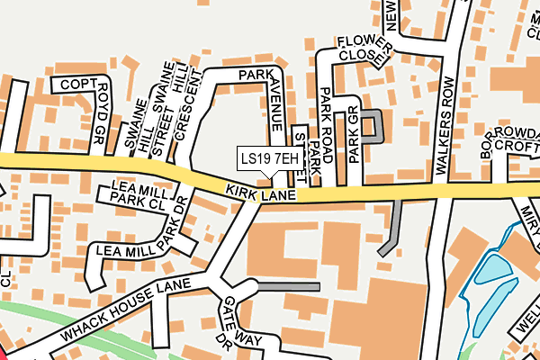
LS19 7EH lies on Park Avenue in Yeadon, Leeds. LS19 7EH is located in the Guiseley & Rawdon electoral ward, within the metropolitan district of Leeds and the English Parliamentary constituency of Pudsey. The Sub Integrated Care Board (ICB) Location is NHS West Yorkshire ICB - 15F and the police force is West Yorkshire. This postcode has been in use since March 2012.


GetTheData
Source: OS OpenMap – Local (Ordnance Survey)
Source: OS VectorMap District (Ordnance Survey)
Licence: Open Government Licence (requires attribution)
| Easting | 420283 |
| Northing | 441144 |
| Latitude | 53.866118 |
| Longitude | -1.693051 |
GetTheData
Source: Open Postcode Geo
Licence: Open Government Licence
| Street | Park Avenue |
| Locality | Yeadon |
| Town/City | Leeds |
| Country | England |
| Postcode District | LS19 |
➜ See where LS19 is on a map ➜ Where is Yeadon? | |
GetTheData
Source: Land Registry Price Paid Data
Licence: Open Government Licence
Elevation or altitude of LS19 7EH as distance above sea level:
| Metres | Feet | |
|---|---|---|
| Elevation | 150m | 492ft |
Elevation is measured from the approximate centre of the postcode, to the nearest point on an OS contour line from OS Terrain 50, which has contour spacing of ten vertical metres.
➜ How high above sea level am I? Find the elevation of your current position using your device's GPS.
GetTheData
Source: Open Postcode Elevation
Licence: Open Government Licence
| Ward | Guiseley & Rawdon |
| Constituency | Pudsey |
GetTheData
Source: ONS Postcode Database
Licence: Open Government Licence
| Kirk Lane Swaine Hill Ter (Kirk Lane) | Yeadon | 60m |
| Kirk Lane Swaine Hill Ter (Kirk Lane) | Yeadon | 77m |
| Kirk Lane | Yeadon | 138m |
| Walkers Row | Yeadon | 221m |
| Walkers Row | Yeadon | 231m |
| Guiseley Station | 1.8km |
| Apperley Bridge Station | 2.8km |
| Menston Station | 4km |
GetTheData
Source: NaPTAN
Licence: Open Government Licence
| Percentage of properties with Next Generation Access | 100.0% |
| Percentage of properties with Superfast Broadband | 100.0% |
| Percentage of properties with Ultrafast Broadband | 0.0% |
| Percentage of properties with Full Fibre Broadband | 0.0% |
Superfast Broadband is between 30Mbps and 300Mbps
Ultrafast Broadband is > 300Mbps
| Percentage of properties unable to receive 2Mbps | 0.0% |
| Percentage of properties unable to receive 5Mbps | 0.0% |
| Percentage of properties unable to receive 10Mbps | 0.0% |
| Percentage of properties unable to receive 30Mbps | 0.0% |
GetTheData
Source: Ofcom
Licence: Ofcom Terms of Use (requires attribution)
GetTheData
Source: ONS Postcode Database
Licence: Open Government Licence


➜ Get more ratings from the Food Standards Agency
GetTheData
Source: Food Standards Agency
Licence: FSA terms & conditions
| Last Collection | |||
|---|---|---|---|
| Location | Mon-Fri | Sat | Distance |
| Kirk Lane P.o. | 17:15 | 12:00 | 17m |
| Royal Mail Aireborough | 17:15 | 12:30 | 326m |
| Westfield Avenue | 17:30 | 12:30 | 400m |
GetTheData
Source: Dracos
Licence: Creative Commons Attribution-ShareAlike
The below table lists the International Territorial Level (ITL) codes (formerly Nomenclature of Territorial Units for Statistics (NUTS) codes) and Local Administrative Units (LAU) codes for LS19 7EH:
| ITL 1 Code | Name |
|---|---|
| TLE | Yorkshire and The Humber |
| ITL 2 Code | Name |
| TLE4 | West Yorkshire |
| ITL 3 Code | Name |
| TLE42 | Leeds |
| LAU 1 Code | Name |
| E08000035 | Leeds |
GetTheData
Source: ONS Postcode Directory
Licence: Open Government Licence
The below table lists the Census Output Area (OA), Lower Layer Super Output Area (LSOA), and Middle Layer Super Output Area (MSOA) for LS19 7EH:
| Code | Name | |
|---|---|---|
| OA | E00056752 | |
| LSOA | E01011273 | Leeds 010B |
| MSOA | E02002339 | Leeds 010 |
GetTheData
Source: ONS Postcode Directory
Licence: Open Government Licence
| LS19 7EY | Park Street | 31m |
| LS19 7HA | Fernbank Terrace | 47m |
| LS19 7EZ | Park Avenue | 90m |
| LS19 7EX | Park Road | 100m |
| LS19 7LX | Kirk Lane | 101m |
| LS19 7HD | Swaine Hill Terrace | 116m |
| LS19 7HE | Swaine Hill Crescent | 130m |
| LS19 7ET | Kirk Lane | 135m |
| LS19 7HF | Swaine Hill Street | 142m |
| LS19 7EU | Park Grove | 142m |
GetTheData
Source: Open Postcode Geo; Land Registry Price Paid Data
Licence: Open Government Licence