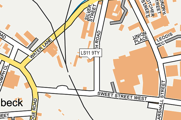
LS11 9TY is located in the Beeston & Holbeck electoral ward, within the metropolitan district of Leeds and the English Parliamentary constituency of Leeds Central. The Sub Integrated Care Board (ICB) Location is NHS West Yorkshire ICB - 15F and the police force is West Yorkshire. This postcode has been in use since January 1980.


GetTheData
Source: OS OpenMap – Local (Ordnance Survey)
Source: OS VectorMap District (Ordnance Survey)
Licence: Open Government Licence (requires attribution)
| Easting | 429364 |
| Northing | 432694 |
| Latitude | 53.789740 |
| Longitude | -1.555769 |
GetTheData
Source: Open Postcode Geo
Licence: Open Government Licence
| Country | England |
| Postcode District | LS11 |
| ➜ LS11 open data dashboard ➜ See where LS11 is on a map ➜ Where is Leeds? | |
GetTheData
Source: Land Registry Price Paid Data
Licence: Open Government Licence
Elevation or altitude of LS11 9TY as distance above sea level:
| Metres | Feet | |
|---|---|---|
| Elevation | 30m | 98ft |
Elevation is measured from the approximate centre of the postcode, to the nearest point on an OS contour line from OS Terrain 50, which has contour spacing of ten vertical metres.
➜ How high above sea level am I? Find the elevation of your current position using your device's GPS.
GetTheData
Source: Open Postcode Elevation
Licence: Open Government Licence
| Ward | Beeston & Holbeck |
| Constituency | Leeds Central |
GetTheData
Source: ONS Postcode Database
Licence: Open Government Licence
5, BATH ROAD, LEEDS, LS11 9TY 2022 31 MAR £250,000 |
GetTheData
Source: HM Land Registry Price Paid Data
Licence: Contains HM Land Registry data © Crown copyright and database right 2024. This data is licensed under the Open Government Licence v3.0.
| June 2022 | Violence and sexual offences | On or near Sweet Street West | 114m |
| June 2022 | Anti-social behaviour | On or near Union Place | 183m |
| June 2022 | Violence and sexual offences | On or near Bridge Road | 240m |
| ➜ Get more crime data in our Crime section | |||
GetTheData
Source: data.police.uk
Licence: Open Government Licence
| Whitehall Rd Globe Road (Whitehall Road) | Holbeck | 450m |
| Whitehall Rd Globe Road (Whitehall Road) | Holbeck | 459m |
| Whitehall Road | Leeds City Centre | 504m |
| Whitehall Road | Leeds City Centre | 511m |
| Domestic Street Balm Walk (Domestic Street) | Holbeck | 513m |
| Leeds Station | 0.8km |
| Burley Park Station | 2.9km |
| Cottingley Station | 3.2km |
GetTheData
Source: NaPTAN
Licence: Open Government Licence
GetTheData
Source: ONS Postcode Database
Licence: Open Government Licence


➜ Get more ratings from the Food Standards Agency
GetTheData
Source: Food Standards Agency
Licence: FSA terms & conditions
| Last Collection | |||
|---|---|---|---|
| Location | Mon-Fri | Sat | Distance |
| Bridge Road/Holbeck Lane | 17:30 | 12:15 | 213m |
| Marshall Street P.o. | 18:30 | 12:30 | 243m |
| Water Lane | 18:30 | 373m | |
GetTheData
Source: Dracos
Licence: Creative Commons Attribution-ShareAlike
| Facility | Distance |
|---|---|
| St Matthews Community Centre St. Matthews Street, Leeds Sports Hall | 536m |
| Anytime Fitness (Leeds) Water Lane, Leeds Health and Fitness Gym | 569m |
| Clayton Hotel Leeds City Walk, Leeds Health and Fitness Gym | 607m |
GetTheData
Source: Active Places
Licence: Open Government Licence
| School | Phase of Education | Distance |
|---|---|---|
| Lane End Primary School Beeston Road, Holbeck, Leeds, LS11 6AA | Primary | 744m |
| Ingram Road Primary School Brown Lane East, Holbeck, Leeds, LS11 9LA | Primary | 814m |
| Beeston Hill St Luke's Church of England Primary School Beeston Road, Leeds, LS11 8ND | Primary | 991m |
GetTheData
Source: Edubase
Licence: Open Government Licence
| Risk of LS11 9TY flooding from rivers and sea | Low |
| ➜ LS11 9TY flood map | |
GetTheData
Source: Open Flood Risk by Postcode
Licence: Open Government Licence
The below table lists the International Territorial Level (ITL) codes (formerly Nomenclature of Territorial Units for Statistics (NUTS) codes) and Local Administrative Units (LAU) codes for LS11 9TY:
| ITL 1 Code | Name |
|---|---|
| TLE | Yorkshire and The Humber |
| ITL 2 Code | Name |
| TLE4 | West Yorkshire |
| ITL 3 Code | Name |
| TLE42 | Leeds |
| LAU 1 Code | Name |
| E08000035 | Leeds |
GetTheData
Source: ONS Postcode Directory
Licence: Open Government Licence
The below table lists the Census Output Area (OA), Lower Layer Super Output Area (LSOA), and Middle Layer Super Output Area (MSOA) for LS11 9TY:
| Code | Name | |
|---|---|---|
| OA | E00170055 | |
| LSOA | E01033032 | Leeds 082F |
| MSOA | E02002411 | Leeds 082 |
GetTheData
Source: ONS Postcode Directory
Licence: Open Government Licence
| LS11 5WF | Butcher Street | 231m |
| LS11 9AB | Marshall Street | 251m |
| LS11 9TE | Sweet Street West | 258m |
| LS11 9QB | Gaitskell Walk | 344m |
| LS11 5QN | Water Lane | 363m |
| LS11 9QF | Nineveh Gardens | 374m |
| LS11 9BN | Ingram Street | 385m |
| LS11 9BR | Ingram Street | 385m |
| LS11 9BT | Ingram Street | 385m |
| LS11 9BU | Ingram Street | 385m |
GetTheData
Source: Open Postcode Geo; Land Registry Price Paid Data
Licence: Open Government Licence