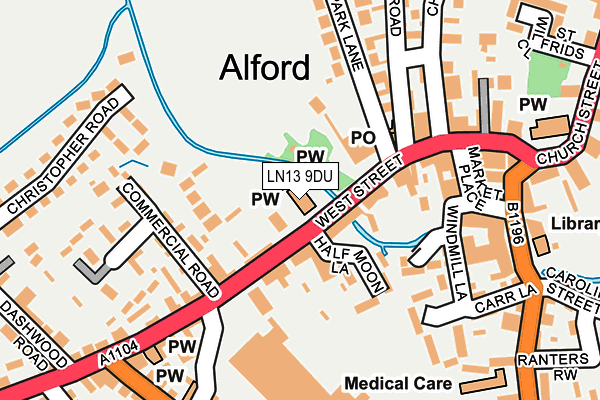
LN13 9DU is located in the Alford electoral ward, within the local authority district of East Lindsey and the English Parliamentary constituency of Louth and Horncastle. The Sub Integrated Care Board (ICB) Location is NHS Lincolnshire ICB - 71E and the police force is Lincolnshire. This postcode has been in use since August 1992.


GetTheData
Source: OS OpenMap – Local (Ordnance Survey)
Source: OS VectorMap District (Ordnance Survey)
Licence: Open Government Licence (requires attribution)
| Easting | 545304 |
| Northing | 375995 |
| Latitude | 53.261061 |
| Longitude | 0.176936 |
GetTheData
Source: Open Postcode Geo
Licence: Open Government Licence
| Country | England |
| Postcode District | LN13 |
| ➜ LN13 open data dashboard ➜ See where LN13 is on a map ➜ Where is Alford? | |
GetTheData
Source: Land Registry Price Paid Data
Licence: Open Government Licence
Elevation or altitude of LN13 9DU as distance above sea level:
| Metres | Feet | |
|---|---|---|
| Elevation | 10m | 33ft |
Elevation is measured from the approximate centre of the postcode, to the nearest point on an OS contour line from OS Terrain 50, which has contour spacing of ten vertical metres.
➜ How high above sea level am I? Find the elevation of your current position using your device's GPS.
GetTheData
Source: Open Postcode Elevation
Licence: Open Government Licence
| Ward | Alford |
| Constituency | Louth And Horncastle |
GetTheData
Source: ONS Postcode Database
Licence: Open Government Licence
| January 2024 | Violence and sexual offences | On or near Market Place | 167m |
| January 2024 | Violence and sexual offences | On or near Market Place | 167m |
| January 2024 | Vehicle crime | On or near Parking Area | 182m |
| ➜ Get more crime data in our Crime section | |||
GetTheData
Source: data.police.uk
Licence: Open Government Licence
| Methodist Church (West Street) | Alford | 38m |
| Methodist Church (West Street) | Alford | 41m |
| Demand Responsive Area | Alford | 181m |
| Library (South Market Place) | Alford | 209m |
| Library (South Market Place) | Alford | 228m |
GetTheData
Source: NaPTAN
Licence: Open Government Licence
GetTheData
Source: ONS Postcode Database
Licence: Open Government Licence


➜ Get more ratings from the Food Standards Agency
GetTheData
Source: Food Standards Agency
Licence: FSA terms & conditions
| Last Collection | |||
|---|---|---|---|
| Location | Mon-Fri | Sat | Distance |
| Willoughby Post Office | 16:15 | 09:45 | 4,379m |
GetTheData
Source: Dracos
Licence: Creative Commons Attribution-ShareAlike
| Facility | Distance |
|---|---|
| Alford Squash Club East Street, Alford Squash Courts | 396m |
| Alford Sports Hall Hanby Lane, Alford Sports Hall, Health and Fitness Gym, Swimming Pool, Grass Pitches, Artificial Grass Pitch | 503m |
| Queen Elizabeth's Grammar (Alford) Station Road, Alford Swimming Pool, Sports Hall, Grass Pitches, Health and Fitness Gym | 508m |
GetTheData
Source: Active Places
Licence: Open Government Licence
| School | Phase of Education | Distance |
|---|---|---|
| John Spendluffe Foundation Technology College Hanby Lane, Alford, LN13 9BL | Secondary | 503m |
| Queen Elizabeth's Grammar Alford - A Selective Academy Station Road, Alford, LN13 9HY | Secondary | 508m |
| Alford Primary School Hanby Lane, Alford, LN13 9BJ | Primary | 567m |
GetTheData
Source: Edubase
Licence: Open Government Licence
| Risk of LN13 9DU flooding from rivers and sea | Very Low |
| ➜ LN13 9DU flood map | |
GetTheData
Source: Open Flood Risk by Postcode
Licence: Open Government Licence
The below table lists the International Territorial Level (ITL) codes (formerly Nomenclature of Territorial Units for Statistics (NUTS) codes) and Local Administrative Units (LAU) codes for LN13 9DU:
| ITL 1 Code | Name |
|---|---|
| TLF | East Midlands (England) |
| ITL 2 Code | Name |
| TLF3 | Lincolnshire |
| ITL 3 Code | Name |
| TLF30 | Lincolnshire CC |
| LAU 1 Code | Name |
| E07000137 | East Lindsey |
GetTheData
Source: ONS Postcode Directory
Licence: Open Government Licence
The below table lists the Census Output Area (OA), Lower Layer Super Output Area (LSOA), and Middle Layer Super Output Area (MSOA) for LN13 9DU:
| Code | Name | |
|---|---|---|
| OA | E00132156 | |
| LSOA | E01026042 | East Lindsey 008A |
| MSOA | E02005431 | East Lindsey 008 |
GetTheData
Source: ONS Postcode Directory
Licence: Open Government Licence
| LN13 9DG | West Street | 58m |
| LN13 9DJ | West Street | 81m |
| LN13 9EN | Nursery Gardens | 108m |
| LN13 9DR | West Street | 129m |
| LN13 9AL | Old Bowling Green | 148m |
| LN13 9EY | Commercial Road | 154m |
| LN13 9AA | Windmill Lane | 182m |
| LN13 9EB | Market Place | 186m |
| LN13 9EZ | West Street | 193m |
| LN13 9DS | High Street | 203m |
GetTheData
Source: Open Postcode Geo; Land Registry Price Paid Data
Licence: Open Government Licence