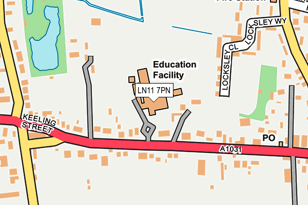
LN11 7PN is located in the Marshchapel & Somercotes electoral ward, within the local authority district of East Lindsey and the English Parliamentary constituency of Louth and Horncastle. The Sub Integrated Care Board (ICB) Location is NHS Lincolnshire ICB - 71E and the police force is Lincolnshire. This postcode has been in use since January 1980.


GetTheData
Source: OS OpenMap – Local (Ordnance Survey)
Source: OS VectorMap District (Ordnance Survey)
Licence: Open Government Licence (requires attribution)
| Easting | 541950 |
| Northing | 396569 |
| Latitude | 53.446772 |
| Longitude | 0.135914 |
GetTheData
Source: Open Postcode Geo
Licence: Open Government Licence
| Country | England |
| Postcode District | LN11 |
| ➜ LN11 open data dashboard ➜ See where LN11 is on a map ➜ Where is North Somercotes? | |
GetTheData
Source: Land Registry Price Paid Data
Licence: Open Government Licence
Elevation or altitude of LN11 7PN as distance above sea level:
| Metres | Feet | |
|---|---|---|
| Elevation | 10m | 33ft |
Elevation is measured from the approximate centre of the postcode, to the nearest point on an OS contour line from OS Terrain 50, which has contour spacing of ten vertical metres.
➜ How high above sea level am I? Find the elevation of your current position using your device's GPS.
GetTheData
Source: Open Postcode Elevation
Licence: Open Government Licence
| Ward | Marshchapel & Somercotes |
| Constituency | Louth And Horncastle |
GetTheData
Source: ONS Postcode Database
Licence: Open Government Licence
| June 2022 | Public order | On or near Jubilee Road | 416m |
| May 2022 | Violence and sexual offences | On or near Sports/Recreation Area | 107m |
| May 2022 | Public order | On or near Locksley Close | 155m |
| ➜ Get more crime data in our Crime section | |||
GetTheData
Source: data.police.uk
Licence: Open Government Licence
| Amvale Coach Depot (Keeling Street) | North Somercotes | 105m |
| Amvale Coach Depot (Keeling Street) | North Somercotes | 122m |
| The Axe And Cleaver Ph (Keeling Street) | North Somercotes | 191m |
| Demand Responsive Area | North Somercotes | 198m |
| The Axe And Cleaver Ph (Keeling Street) | North Somercotes | 204m |
GetTheData
Source: NaPTAN
Licence: Open Government Licence
GetTheData
Source: ONS Postcode Database
Licence: Open Government Licence


➜ Get more ratings from the Food Standards Agency
GetTheData
Source: Food Standards Agency
Licence: FSA terms & conditions
| Last Collection | |||
|---|---|---|---|
| Location | Mon-Fri | Sat | Distance |
| Conisholme | 16:15 | 08:45 | 1,995m |
| Ludney | 16:15 | 10:15 | 2,490m |
| Grainthorpe P.o. | 16:30 | 08:00 | 3,496m |
GetTheData
Source: Dracos
Licence: Creative Commons Attribution-ShareAlike
| Facility | Distance |
|---|---|
| Somercotes Academy Keeling Street, North Somercotes, Louth Grass Pitches, Sports Hall | 0m |
| North Somercoates Playing Field Keeling Street, North Somercotes, Louth Grass Pitches | 439m |
| Grainthorpe Playing Field Main Road, Grainthorpe, Louth Grass Pitches, Outdoor Tennis Courts | 3.8km |
GetTheData
Source: Active Places
Licence: Open Government Licence
| School | Phase of Education | Distance |
|---|---|---|
| Somercotes Academy Keeling Street, North Somercotes, Louth, LN11 7PN | Secondary | 0m |
| North Somercotes CofE Primary School Warren Road, North Somercotes, Louth, LN11 7QB | Primary | 902m |
| Grainthorpe Junior School Fen Lane, Grainthorpe, Louth, LN11 7JY | Primary | 3.7km |
GetTheData
Source: Edubase
Licence: Open Government Licence
| Risk of LN11 7PN flooding from rivers and sea | Low |
| ➜ LN11 7PN flood map | |
GetTheData
Source: Open Flood Risk by Postcode
Licence: Open Government Licence
The below table lists the International Territorial Level (ITL) codes (formerly Nomenclature of Territorial Units for Statistics (NUTS) codes) and Local Administrative Units (LAU) codes for LN11 7PN:
| ITL 1 Code | Name |
|---|---|
| TLF | East Midlands (England) |
| ITL 2 Code | Name |
| TLF3 | Lincolnshire |
| ITL 3 Code | Name |
| TLF30 | Lincolnshire CC |
| LAU 1 Code | Name |
| E07000137 | East Lindsey |
GetTheData
Source: ONS Postcode Directory
Licence: Open Government Licence
The below table lists the Census Output Area (OA), Lower Layer Super Output Area (LSOA), and Middle Layer Super Output Area (MSOA) for LN11 7PN:
| Code | Name | |
|---|---|---|
| OA | E00132372 | |
| LSOA | E01026079 | East Lindsey 002C |
| MSOA | E02005425 | East Lindsey 002 |
GetTheData
Source: ONS Postcode Directory
Licence: Open Government Licence
| LN11 7PW | Keeling Street | 106m |
| LN11 7PL | Keeling Street | 129m |
| LN11 7PR | Keeling Street | 221m |
| LN11 7QR | Locksley Way | 247m |
| LN11 7QP | Sandy Lane | 248m |
| LN11 7QJ | Keeling Street | 268m |
| LN11 7QN | Keeling Street | 292m |
| LN11 7RF | Churchill Close | 325m |
| LN11 7PE | Evison Way | 334m |
| LN11 7QW | Churchill Road | 334m |
GetTheData
Source: Open Postcode Geo; Land Registry Price Paid Data
Licence: Open Government Licence