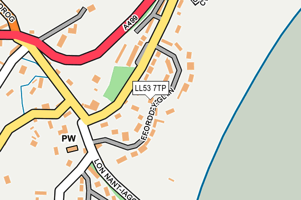
LL53 7TP lies on Ffordd Y Glyn in Llanbedrog, Pwllheli. LL53 7TP is located in the Llanbedrog gyda Mynytho electoral ward, within the unitary authority of Gwynedd and the Welsh Parliamentary constituency of Dwyfor Meirionnydd. The Local Health Board is Betsi Cadwaladr University and the police force is North Wales. This postcode has been in use since January 1980.


GetTheData
Source: OS OpenMap – Local (Ordnance Survey)
Source: OS VectorMap District (Ordnance Survey)
Licence: Open Government Licence (requires attribution)
| Easting | 233101 |
| Northing | 331649 |
| Latitude | 52.856390 |
| Longitude | -4.480296 |
GetTheData
Source: Open Postcode Geo
Licence: Open Government Licence
| Street | Ffordd Y Glyn |
| Locality | Llanbedrog |
| Town/City | Pwllheli |
| Country | Wales |
| Postcode District | LL53 |
➜ See where LL53 is on a map ➜ Where is Llanbedrog? | |
GetTheData
Source: Land Registry Price Paid Data
Licence: Open Government Licence
Elevation or altitude of LL53 7TP as distance above sea level:
| Metres | Feet | |
|---|---|---|
| Elevation | 20m | 66ft |
Elevation is measured from the approximate centre of the postcode, to the nearest point on an OS contour line from OS Terrain 50, which has contour spacing of ten vertical metres.
➜ How high above sea level am I? Find the elevation of your current position using your device's GPS.
GetTheData
Source: Open Postcode Elevation
Licence: Open Government Licence
| Ward | Llanbedrog Gyda Mynytho |
| Constituency | Dwyfor Meirionnydd |
GetTheData
Source: ONS Postcode Database
Licence: Open Government Licence
TIME & TIDE, FFORDD Y GLYN, LLANBEDROG, PWLLHELI, LL53 7TP 2019 30 MAY £420,000 |
2018 29 JUN £460,000 |
2016 5 OCT £615,000 |
2015 11 SEP £472,500 |
2014 10 JUL £425,000 |
PORTH-Y-CWMWD, FFORDD Y GLYN, LLANBEDROG, PWLLHELI, LL53 7TP 2013 18 NOV £655,000 |
2007 21 MAY £350,000 |
CRI Y WYLAN, FFORDD Y GLYN, LLANBEDROG, PWLLHELI, LL53 7TP 2006 16 JUN £432,000 |
2006 31 MAR £350,000 |
GLANFOR, FFORDD Y GLYN, LLANBEDROG, PWLLHELI, LL53 7TP 2005 26 JUL £265,000 |
GetTheData
Source: HM Land Registry Price Paid Data
Licence: Contains HM Land Registry data © Crown copyright and database right 2025. This data is licensed under the Open Government Licence v3.0.
| Glyn Y Weddw (A499) | Llanbedrog | 247m |
| Glyn Y Weddw (A499) | Llanbedrog | 270m |
| Glyn Garth Hotel (A499) | Llanbedrog | 342m |
| Glyn Garth Hotel (A499) | Llanbedrog | 345m |
| Glyn Y Weddw West (B4413) | Llanbedrog | 353m |
| Pwllheli Station | 5.5km |
GetTheData
Source: NaPTAN
Licence: Open Government Licence
| Percentage of properties with Next Generation Access | 100.0% |
| Percentage of properties with Superfast Broadband | 100.0% |
| Percentage of properties with Ultrafast Broadband | 0.0% |
| Percentage of properties with Full Fibre Broadband | 0.0% |
Superfast Broadband is between 30Mbps and 300Mbps
Ultrafast Broadband is > 300Mbps
| Median download speed | 35.0Mbps |
| Average download speed | 40.7Mbps |
| Maximum download speed | 73.45Mbps |
| Median upload speed | 9.6Mbps |
| Average upload speed | 9.7Mbps |
| Maximum upload speed | 19.84Mbps |
| Percentage of properties unable to receive 2Mbps | 0.0% |
| Percentage of properties unable to receive 5Mbps | 0.0% |
| Percentage of properties unable to receive 10Mbps | 0.0% |
| Percentage of properties unable to receive 30Mbps | 0.0% |
GetTheData
Source: Ofcom
Licence: Ofcom Terms of Use (requires attribution)
Estimated total energy consumption in LL53 7TP by fuel type, 2015.
| Consumption (kWh) | 109,372 |
|---|---|
| Meter count | 28 |
| Mean (kWh/meter) | 3,906 |
| Median (kWh/meter) | 3,241 |
GetTheData
Source: Postcode level gas estimates: 2015 (experimental)
Source: Postcode level electricity estimates: 2015 (experimental)
Licence: Open Government Licence
GetTheData
Source: ONS Postcode Database
Licence: Open Government Licence


➜ Get more ratings from the Food Standards Agency
GetTheData
Source: Food Standards Agency
Licence: FSA terms & conditions
| Last Collection | |||
|---|---|---|---|
| Location | Mon-Fri | Sat | Distance |
| Glynyweddw | 16:30 | 11:30 | 145m |
| Llanbedrog Village | 16:34 | 11:30 | 606m |
| Llanbedrog Post Office | 16:34 | 11:30 | 839m |
GetTheData
Source: Dracos
Licence: Creative Commons Attribution-ShareAlike
The below table lists the International Territorial Level (ITL) codes (formerly Nomenclature of Territorial Units for Statistics (NUTS) codes) and Local Administrative Units (LAU) codes for LL53 7TP:
| ITL 1 Code | Name |
|---|---|
| TLL | Wales |
| ITL 2 Code | Name |
| TLL1 | West Wales and The Valleys |
| ITL 3 Code | Name |
| TLL12 | Gwynedd |
| LAU 1 Code | Name |
| W06000002 | Gwynedd |
GetTheData
Source: ONS Postcode Directory
Licence: Open Government Licence
The below table lists the Census Output Area (OA), Lower Layer Super Output Area (LSOA), and Middle Layer Super Output Area (MSOA) for LL53 7TP:
| Code | Name | |
|---|---|---|
| OA | W00000409 | |
| LSOA | W01000080 | Gwynedd 014C |
| MSOA | W02000023 | Gwynedd 014 |
GetTheData
Source: ONS Postcode Directory
Licence: Open Government Licence
| LL53 7TN | Beach Road | 77m |
| LL53 7UT | Cae Dwr | 100m |
| LL53 7TW | Glyn Y Marian | 137m |
| LL53 7TS | 182m | |
| LL53 7TL | 195m | |
| LL53 7TG | 210m | |
| LL53 7TU | 234m | |
| LL53 7TT | Glynyweddw Estate | 252m |
| LL53 7TY | 327m | |
| LL53 7NW | Glyn Y Mor | 360m |
GetTheData
Source: Open Postcode Geo; Land Registry Price Paid Data
Licence: Open Government Licence