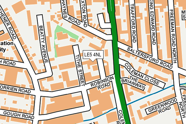
LE5 4NL is located in the North Evington electoral ward, within the unitary authority of Leicester and the English Parliamentary constituency of Leicester East. The Sub Integrated Care Board (ICB) Location is NHS Leicester, Leicestershire and Rutland ICB - 04C and the police force is Leicestershire. This postcode has been in use since January 1980.


GetTheData
Source: OS OpenMap – Local (Ordnance Survey)
Source: OS VectorMap District (Ordnance Survey)
Licence: Open Government Licence (requires attribution)
| Easting | 461503 |
| Northing | 305102 |
| Latitude | 52.640204 |
| Longitude | -1.092536 |
GetTheData
Source: Open Postcode Geo
Licence: Open Government Licence
| Country | England |
| Postcode District | LE5 |
| ➜ LE5 open data dashboard ➜ See where LE5 is on a map ➜ Where is Leicester? | |
GetTheData
Source: Land Registry Price Paid Data
Licence: Open Government Licence
Elevation or altitude of LE5 4NL as distance above sea level:
| Metres | Feet | |
|---|---|---|
| Elevation | 60m | 197ft |
Elevation is measured from the approximate centre of the postcode, to the nearest point on an OS contour line from OS Terrain 50, which has contour spacing of ten vertical metres.
➜ How high above sea level am I? Find the elevation of your current position using your device's GPS.
GetTheData
Source: Open Postcode Elevation
Licence: Open Government Licence
| Ward | North Evington |
| Constituency | Leicester East |
GetTheData
Source: ONS Postcode Database
Licence: Open Government Licence
| December 2023 | Drugs | On or near The Portwey | 405m |
| December 2023 | Anti-social behaviour | On or near The Portwey | 405m |
| December 2023 | Criminal damage and arson | On or near The Portwey | 405m |
| ➜ Get more crime data in our Crime section | |||
GetTheData
Source: data.police.uk
Licence: Open Government Licence
| Exton Road (Uppingham Road) | New Humberstone | 216m |
| Exton Road (Uppingham Road) | New Humberstone | 237m |
| King Edward Road (Uppingham Road) | New Humberstone | 257m |
| Green Lane Close (Green Lane Road) | North Evington | 297m |
| Tithe Street (Green Lane Road) | North Evington | 302m |
| Leicester Station | 2.4km |
GetTheData
Source: NaPTAN
Licence: Open Government Licence
GetTheData
Source: ONS Postcode Database
Licence: Open Government Licence


➜ Get more ratings from the Food Standards Agency
GetTheData
Source: Food Standards Agency
Licence: FSA terms & conditions
| Last Collection | |||
|---|---|---|---|
| Location | Mon-Fri | Sat | Distance |
| Uppingham Road Post Office | 17:30 | 12:00 | 414m |
| Woodhill Post Office | 17:30 | 12:00 | 827m |
| Park Vale Post Office | 17:30 | 12:00 | 883m |
GetTheData
Source: Dracos
Licence: Creative Commons Attribution-ShareAlike
| Facility | Distance |
|---|---|
| Spence Street Sports Centre Spence Street, Leicester Sports Hall, Swimming Pool, Health and Fitness Gym, Studio | 518m |
| Humberstone Park Uppingham Road, Leicester Grass Pitches, Outdoor Tennis Courts | 544m |
| Merrydale Junior School Claydon Road, Leicester Grass Pitches | 577m |
GetTheData
Source: Active Places
Licence: Open Government Licence
| School | Phase of Education | Distance |
|---|---|---|
| St Barnabas CofE Primary School St Barnabas Road, Leicester, LE5 4BD | Primary | 329m |
| Al-Aqsa Schools Trust The Wayne Way, Leicester, Leicester, LE5 4PP | Not applicable | 480m |
| Merrydale Junior School Claydon Road, Leicester, LE5 0PL | Primary | 571m |
GetTheData
Source: Edubase
Licence: Open Government Licence
| Risk of LE5 4NL flooding from rivers and sea | Low |
| ➜ LE5 4NL flood map | |
GetTheData
Source: Open Flood Risk by Postcode
Licence: Open Government Licence
The below table lists the International Territorial Level (ITL) codes (formerly Nomenclature of Territorial Units for Statistics (NUTS) codes) and Local Administrative Units (LAU) codes for LE5 4NL:
| ITL 1 Code | Name |
|---|---|
| TLF | East Midlands (England) |
| ITL 2 Code | Name |
| TLF2 | Leicestershire, Rutland and Northamptonshire |
| ITL 3 Code | Name |
| TLF21 | Leicester |
| LAU 1 Code | Name |
| E06000016 | Leicester |
GetTheData
Source: ONS Postcode Directory
Licence: Open Government Licence
The below table lists the Census Output Area (OA), Lower Layer Super Output Area (LSOA), and Middle Layer Super Output Area (MSOA) for LE5 4NL:
| Code | Name | |
|---|---|---|
| OA | E00068964 | |
| LSOA | E01013665 | Leicester 019D |
| MSOA | E02002845 | Leicester 019 |
GetTheData
Source: ONS Postcode Directory
Licence: Open Government Licence
| LE5 4AR | Haynes Road | 111m |
| LE5 4BN | Tithe Street | 125m |
| LE5 4AD | Coleman Road | 130m |
| LE5 4AQ | Haynes Road | 138m |
| LE5 4AE | Coleman Road | 139m |
| LE5 4AF | Exton Road | 149m |
| LE5 4AB | Beatty Road | 157m |
| LE5 4BL | Trafford Road | 162m |
| LE5 4DE | Saltersford Road | 165m |
| LE5 4AA | Beatty Avenue | 167m |
GetTheData
Source: Open Postcode Geo; Land Registry Price Paid Data
Licence: Open Government Licence