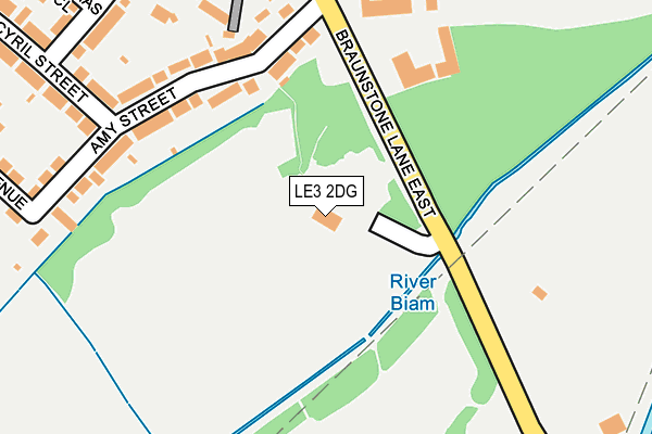
LE3 2DG is located in the Aylestone electoral ward, within the unitary authority of Leicester and the English Parliamentary constituency of Leicester South. The Sub Integrated Care Board (ICB) Location is NHS Leicester, Leicestershire and Rutland ICB - 04C and the police force is Leicestershire. This postcode has been in use since February 2013.


GetTheData
Source: OS OpenMap – Local (Ordnance Survey)
Source: OS VectorMap District (Ordnance Survey)
Licence: Open Government Licence (requires attribution)
| Easting | 456690 |
| Northing | 301465 |
| Latitude | 52.608016 |
| Longitude | -1.164285 |
GetTheData
Source: Open Postcode Geo
Licence: Open Government Licence
| Country | England |
| Postcode District | LE3 |
| ➜ LE3 open data dashboard ➜ See where LE3 is on a map | |
GetTheData
Source: Land Registry Price Paid Data
Licence: Open Government Licence
Elevation or altitude of LE3 2DG as distance above sea level:
| Metres | Feet | |
|---|---|---|
| Elevation | 60m | 197ft |
Elevation is measured from the approximate centre of the postcode, to the nearest point on an OS contour line from OS Terrain 50, which has contour spacing of ten vertical metres.
➜ How high above sea level am I? Find the elevation of your current position using your device's GPS.
GetTheData
Source: Open Postcode Elevation
Licence: Open Government Licence
| Ward | Aylestone |
| Constituency | Leicester South |
GetTheData
Source: ONS Postcode Database
Licence: Open Government Licence
| November 2023 | Criminal damage and arson | On or near Sports/Recreation Area | 240m |
| November 2023 | Violence and sexual offences | On or near Sports/Recreation Area | 240m |
| October 2023 | Criminal damage and arson | On or near Sports/Recreation Area | 240m |
| ➜ Get more crime data in our Crime section | |||
GetTheData
Source: data.police.uk
Licence: Open Government Licence
| Ellesmere College (Braunstone Lane East) | Leicester | 229m |
| Ellesmere College (Braunstone Lane East) | Leicester | 295m |
| Rosamund Avenue (Narborough Road South (East)) | Braunstone | 382m |
| Rosamund Avenue (Narborough Road South (West)) | Braunstone | 430m |
| The Crossway (Narborough Road South) | Braunstone | 452m |
| South Wigston Station | 3.5km |
| Leicester Station | 3.7km |
| Narborough Station | 4.9km |
GetTheData
Source: NaPTAN
Licence: Open Government Licence
GetTheData
Source: ONS Postcode Database
Licence: Open Government Licence


➜ Get more ratings from the Food Standards Agency
GetTheData
Source: Food Standards Agency
Licence: FSA terms & conditions
| Last Collection | |||
|---|---|---|---|
| Location | Mon-Fri | Sat | Distance |
| The Crossway | 17:00 | 12:00 | 481m |
| Gwencole Crescent Post Office | 17:00 | 12:00 | 522m |
| Ayston Road Post Office | 17:00 | 12:00 | 816m |
GetTheData
Source: Dracos
Licence: Creative Commons Attribution-ShareAlike
| Facility | Distance |
|---|---|
| Aylestone Playing Fields Braunstone Lane East, Leicester Grass Pitches, Outdoor Tennis Courts | 110m |
| Riverside Football Ground Braunstone Lane East, Leicester Grass Pitches, Artificial Grass Pitch | 270m |
| Lcc Employees Ground Braunstone Lane East, Leicester Grass Pitches | 276m |
GetTheData
Source: Active Places
Licence: Open Government Licence
| School | Phase of Education | Distance |
|---|---|---|
| Ellesmere College 40 Braunstone Lane East, Leicester, LE3 2FD | Not applicable | 385m |
| Ravenhurst Primary School Ravenhurst Road, Braunstone Town, Leicester, LE3 2PS | Primary | 920m |
| Granby Primary School Granby Road, Leicester, LE2 8LP | Primary | 947m |
GetTheData
Source: Edubase
Licence: Open Government Licence
| Risk of LE3 2DG flooding from rivers and sea | High |
| ➜ LE3 2DG flood map | |
GetTheData
Source: Open Flood Risk by Postcode
Licence: Open Government Licence
The below table lists the International Territorial Level (ITL) codes (formerly Nomenclature of Territorial Units for Statistics (NUTS) codes) and Local Administrative Units (LAU) codes for LE3 2DG:
| ITL 1 Code | Name |
|---|---|
| TLF | East Midlands (England) |
| ITL 2 Code | Name |
| TLF2 | Leicestershire, Rutland and Northamptonshire |
| ITL 3 Code | Name |
| TLF21 | Leicester |
| LAU 1 Code | Name |
| E06000016 | Leicester |
GetTheData
Source: ONS Postcode Directory
Licence: Open Government Licence
The below table lists the Census Output Area (OA), Lower Layer Super Output Area (LSOA), and Middle Layer Super Output Area (MSOA) for LE3 2DG:
| Code | Name | |
|---|---|---|
| OA | E00068717 | |
| LSOA | E01013609 | Leicester 034B |
| MSOA | E02002860 | Leicester 034 |
GetTheData
Source: ONS Postcode Directory
Licence: Open Government Licence
| LE3 2FB | Amy Street | 170m |
| LE3 2FA | Amy Street | 201m |
| LE3 2FE | Cottage Row | 266m |
| LE3 2FF | Cyril Street | 302m |
| LE3 2FL | Percy Street | 307m |
| LE3 2FD | Braunstone Lane East | 316m |
| LE3 2FG | Gwencole Avenue | 318m |
| LE3 2FX | Thomas Close | 348m |
| LE3 2FP | Narborough Road South | 377m |
| LE3 2FN | Narborough Road South | 405m |
GetTheData
Source: Open Postcode Geo; Land Registry Price Paid Data
Licence: Open Government Licence