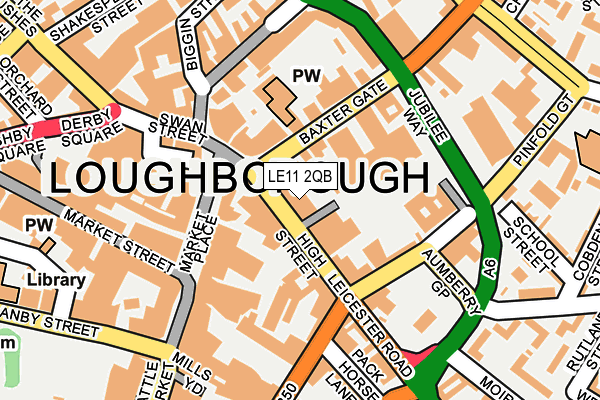
LE11 2QB is located in the Loughborough Southfields electoral ward, within the local authority district of Charnwood and the English Parliamentary constituency of Loughborough. The Sub Integrated Care Board (ICB) Location is NHS Leicester, Leicestershire and Rutland ICB - 04V and the police force is Leicestershire. This postcode has been in use since January 1980.


GetTheData
Source: OS OpenMap – Local (Ordnance Survey)
Source: OS VectorMap District (Ordnance Survey)
Licence: Open Government Licence (requires attribution)
| Easting | 453732 |
| Northing | 319634 |
| Latitude | 52.771633 |
| Longitude | -1.205001 |
GetTheData
Source: Open Postcode Geo
Licence: Open Government Licence
| Country | England |
| Postcode District | LE11 |
| ➜ LE11 open data dashboard ➜ See where LE11 is on a map ➜ Where is Loughborough? | |
GetTheData
Source: Land Registry Price Paid Data
Licence: Open Government Licence
Elevation or altitude of LE11 2QB as distance above sea level:
| Metres | Feet | |
|---|---|---|
| Elevation | 40m | 131ft |
Elevation is measured from the approximate centre of the postcode, to the nearest point on an OS contour line from OS Terrain 50, which has contour spacing of ten vertical metres.
➜ How high above sea level am I? Find the elevation of your current position using your device's GPS.
GetTheData
Source: Open Postcode Elevation
Licence: Open Government Licence
| Ward | Loughborough Southfields |
| Constituency | Loughborough |
GetTheData
Source: ONS Postcode Database
Licence: Open Government Licence
| January 2024 | Public order | On or near Biggin Street | 222m |
| January 2024 | Public order | On or near Biggin Street | 222m |
| January 2024 | Shoplifting | On or near Biggin Street | 222m |
| ➜ Get more crime data in our Crime section | |||
GetTheData
Source: data.police.uk
Licence: Open Government Licence
| High Street | Loughborough | 28m |
| High Street | Loughborough | 32m |
| High Street | Loughborough | 36m |
| Baxter Gate | Loughborough | 61m |
| Baxter Gate | Loughborough | 71m |
| Loughborough Central (Great Central Railway) | Loughborough | 707m |
| Loughborough (Leics) Station | 1km |
| Barrow upon Soar Station | 4.8km |
GetTheData
Source: NaPTAN
Licence: Open Government Licence
GetTheData
Source: ONS Postcode Database
Licence: Open Government Licence


➜ Get more ratings from the Food Standards Agency
GetTheData
Source: Food Standards Agency
Licence: FSA terms & conditions
| Last Collection | |||
|---|---|---|---|
| Location | Mon-Fri | Sat | Distance |
| High Street | 18:30 | 11:15 | 61m |
| Cattlemarket | 18:30 | 12:00 | 180m |
| Burns Road | 17:15 | 10:30 | 382m |
GetTheData
Source: Dracos
Licence: Creative Commons Attribution-ShareAlike
| Facility | Distance |
|---|---|
| Jim Play High Street, Loughborough Health and Fitness Gym | 36m |
| Dynamite Gym Ltd High Street, Loughborough Health and Fitness Gym, Studio | 85m |
| John Skillen Martial Arts & Fitness Centre Pinfold Gate, Loughborough Health and Fitness Gym, Studio | 244m |
GetTheData
Source: Active Places
Licence: Open Government Licence
| School | Phase of Education | Distance |
|---|---|---|
| ASPIRE: Lifeskills Town Hall Chambers, Town Hall Passage, Loughborough, Leicestershire, LE11 3EB | Not applicable | 127m |
| Cobden Primary School & Community Centre Cobden Street, Loughborough, LE11 1AF | Primary | 295m |
| Limehurst Academy Bridge Street, Loughborough, LE11 1NH | Secondary | 473m |
GetTheData
Source: Edubase
Licence: Open Government Licence
The below table lists the International Territorial Level (ITL) codes (formerly Nomenclature of Territorial Units for Statistics (NUTS) codes) and Local Administrative Units (LAU) codes for LE11 2QB:
| ITL 1 Code | Name |
|---|---|
| TLF | East Midlands (England) |
| ITL 2 Code | Name |
| TLF2 | Leicestershire, Rutland and Northamptonshire |
| ITL 3 Code | Name |
| TLF22 | Leicestershire CC and Rutland |
| LAU 1 Code | Name |
| E07000130 | Charnwood |
GetTheData
Source: ONS Postcode Directory
Licence: Open Government Licence
The below table lists the Census Output Area (OA), Lower Layer Super Output Area (LSOA), and Middle Layer Super Output Area (MSOA) for LE11 2QB:
| Code | Name | |
|---|---|---|
| OA | E00130418 | |
| LSOA | E01025699 | Charnwood 002A |
| MSOA | E02005346 | Charnwood 002 |
GetTheData
Source: ONS Postcode Directory
Licence: Open Government Licence
| LE11 2PY | High Street | 14m |
| LE11 2PZ | High Street | 37m |
| LE11 1TH | Baxter Gate | 65m |
| LE11 2QL | High Street | 74m |
| LE11 1TG | Baxter Gate | 92m |
| LE11 1TN | Baxter Gate | 94m |
| LE11 1BG | Pinfold Gate | 112m |
| LE11 3EA | Market Place | 115m |
| LE11 2XE | Woodgate | 116m |
| LE11 1UE | Church Gate | 162m |
GetTheData
Source: Open Postcode Geo; Land Registry Price Paid Data
Licence: Open Government Licence