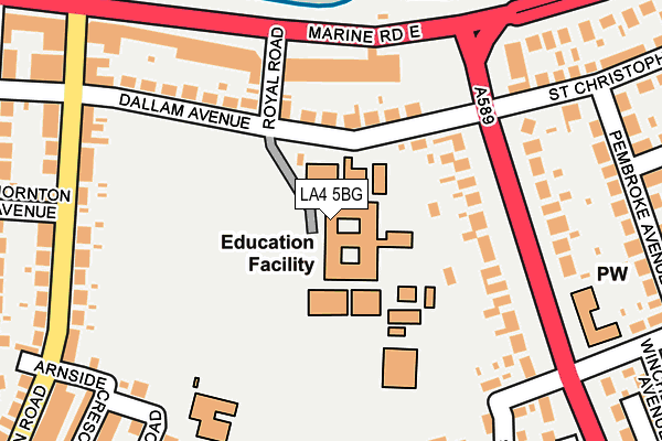
LA4 5BG is located in the Poulton electoral ward, within the local authority district of Lancaster and the English Parliamentary constituency of Morecambe and Lunesdale. The Sub Integrated Care Board (ICB) Location is NHS Lancashire and South Cumbria ICB - 01K and the police force is Lancashire. This postcode has been in use since January 1980.


GetTheData
Source: OS OpenMap – Local (Ordnance Survey)
Source: OS VectorMap District (Ordnance Survey)
Licence: Open Government Licence (requires attribution)
| Easting | 344461 |
| Northing | 464727 |
| Latitude | 54.075460 |
| Longitude | -2.850296 |
GetTheData
Source: Open Postcode Geo
Licence: Open Government Licence
| Country | England |
| Postcode District | LA4 |
| ➜ LA4 open data dashboard ➜ See where LA4 is on a map ➜ Where is Morecambe? | |
GetTheData
Source: Land Registry Price Paid Data
Licence: Open Government Licence
Elevation or altitude of LA4 5BG as distance above sea level:
| Metres | Feet | |
|---|---|---|
| Elevation | 10m | 33ft |
Elevation is measured from the approximate centre of the postcode, to the nearest point on an OS contour line from OS Terrain 50, which has contour spacing of ten vertical metres.
➜ How high above sea level am I? Find the elevation of your current position using your device's GPS.
GetTheData
Source: Open Postcode Elevation
Licence: Open Government Licence
| Ward | Poulton |
| Constituency | Morecambe And Lunesdale |
GetTheData
Source: ONS Postcode Database
Licence: Open Government Licence
| January 2024 | Violence and sexual offences | On or near Thornton Avenue | 279m |
| January 2024 | Vehicle crime | On or near Thornton Avenue | 279m |
| January 2024 | Criminal damage and arson | On or near Thornton Avenue | 279m |
| ➜ Get more crime data in our Crime section | |||
GetTheData
Source: data.police.uk
Licence: Open Government Licence
| High School (Dallam Avenue) | Morecambe | 77m |
| High School (Dallam Avenue) | Morecambe | 127m |
| Broadway (Marine Road East) | Morecambe | 177m |
| Broadway (Marine Road East) | Morecambe | 191m |
| Thornton Road (Promenade) | Morecambe | 300m |
| Bare Lane Station | 1km |
| Morecambe Station | 1.4km |
| Lancaster Station | 4.1km |
GetTheData
Source: NaPTAN
Licence: Open Government Licence
GetTheData
Source: ONS Postcode Database
Licence: Open Government Licence


➜ Get more ratings from the Food Standards Agency
GetTheData
Source: Food Standards Agency
Licence: FSA terms & conditions
| Last Collection | |||
|---|---|---|---|
| Location | Mon-Fri | Sat | Distance |
| Broadway | 16:45 | 11:45 | 167m |
| 68 Thornton Road | 17:00 | 11:15 | 278m |
| 11 Stuart Avenue, Bare | 16:00 | 11:15 | 377m |
GetTheData
Source: Dracos
Licence: Creative Commons Attribution-ShareAlike
| Facility | Distance |
|---|---|
| Morecambe Bay Academy Dallam Avenue, Morecambe Health and Fitness Gym, Grass Pitches, Sports Hall, Studio, Artificial Grass Pitch, Outdoor Tennis Courts | 0m |
| St Mary's Catholic Primary School Coniston Road, Morecambe Grass Pitches | 207m |
| Lancaster Road Primary School Lancaster Road, Morecambe Grass Pitches | 771m |
GetTheData
Source: Active Places
Licence: Open Government Licence
| School | Phase of Education | Distance |
|---|---|---|
| Morecambe Bay Academy Dallam Avenue, Morecambe, LA4 5BG | Secondary | 0m |
| St Mary's Catholic Primary School, Morecambe Coniston Road, Morecambe, LA4 5PS | Primary | 295m |
| Poulton-le-Sands Church of England Primary School Church Street, Morecambe, LA4 5QA | Primary | 536m |
GetTheData
Source: Edubase
Licence: Open Government Licence
| Risk of LA4 5BG flooding from rivers and sea | Low |
| ➜ LA4 5BG flood map | |
GetTheData
Source: Open Flood Risk by Postcode
Licence: Open Government Licence
The below table lists the International Territorial Level (ITL) codes (formerly Nomenclature of Territorial Units for Statistics (NUTS) codes) and Local Administrative Units (LAU) codes for LA4 5BG:
| ITL 1 Code | Name |
|---|---|
| TLD | North West (England) |
| ITL 2 Code | Name |
| TLD4 | Lancashire |
| ITL 3 Code | Name |
| TLD44 | Lancaster and Wyre |
| LAU 1 Code | Name |
| E07000121 | Lancaster |
GetTheData
Source: ONS Postcode Directory
Licence: Open Government Licence
The below table lists the Census Output Area (OA), Lower Layer Super Output Area (LSOA), and Middle Layer Super Output Area (MSOA) for LA4 5BG:
| Code | Name | |
|---|---|---|
| OA | E00127324 | |
| LSOA | E01025087 | Lancaster 004C |
| MSOA | E02005224 | Lancaster 004 |
GetTheData
Source: ONS Postcode Directory
Licence: Open Government Licence
| LA4 5BD | Dallam Avenue | 106m |
| LA4 5BB | Dallam Avenue | 131m |
| LA4 5AR | Marine Road East | 140m |
| LA4 5BQ | Broadway | 148m |
| LA4 5BL | St Andrews Grove | 208m |
| LA4 5BH | Broadway | 212m |
| LA4 5AN | Marine Road East | 218m |
| LA4 5BJ | Broadway | 221m |
| LA4 5PE | Thornton Road | 229m |
| LA4 5PF | Thornton Road | 240m |
GetTheData
Source: Open Postcode Geo; Land Registry Price Paid Data
Licence: Open Government Licence