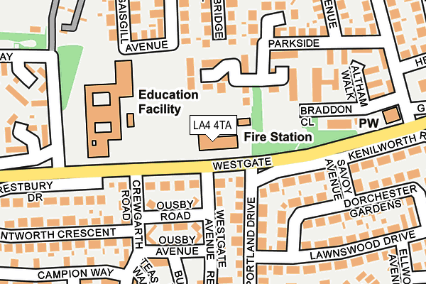
LA4 4TA is located in the Westgate electoral ward, within the local authority district of Lancaster and the English Parliamentary constituency of Morecambe and Lunesdale. The Sub Integrated Care Board (ICB) Location is NHS Lancashire and South Cumbria ICB - 01K and the police force is Lancashire. This postcode has been in use since March 2003.


GetTheData
Source: OS OpenMap – Local (Ordnance Survey)
Source: OS VectorMap District (Ordnance Survey)
Licence: Open Government Licence (requires attribution)
| Easting | 343878 |
| Northing | 463072 |
| Latitude | 54.060524 |
| Longitude | -2.858898 |
GetTheData
Source: Open Postcode Geo
Licence: Open Government Licence
| Country | England |
| Postcode District | LA4 |
| ➜ LA4 open data dashboard ➜ See where LA4 is on a map ➜ Where is Morecambe? | |
GetTheData
Source: Land Registry Price Paid Data
Licence: Open Government Licence
Elevation or altitude of LA4 4TA as distance above sea level:
| Metres | Feet | |
|---|---|---|
| Elevation | 10m | 33ft |
Elevation is measured from the approximate centre of the postcode, to the nearest point on an OS contour line from OS Terrain 50, which has contour spacing of ten vertical metres.
➜ How high above sea level am I? Find the elevation of your current position using your device's GPS.
GetTheData
Source: Open Postcode Elevation
Licence: Open Government Licence
| Ward | Westgate |
| Constituency | Morecambe And Lunesdale |
GetTheData
Source: ONS Postcode Database
Licence: Open Government Licence
| January 2024 | Anti-social behaviour | On or near Riverview Court | 97m |
| January 2024 | Violence and sexual offences | On or near Riverview Court | 97m |
| January 2024 | Anti-social behaviour | On or near Riverview Court | 97m |
| ➜ Get more crime data in our Crime section | |||
GetTheData
Source: data.police.uk
Licence: Open Government Licence
| Fire Station (Westgate) | Westgate | 32m |
| Fire Station (Westgate) | Westgate | 43m |
| Westgate Primary School (Westgate) | Westgate | 159m |
| William Mitchell (Westgate) | Westgate | 229m |
| Hampsfell Drive | Westgate | 234m |
| Morecambe Station | 1.3km |
| Bare Lane Station | 2.2km |
| Lancaster Station | 3.6km |
GetTheData
Source: NaPTAN
Licence: Open Government Licence
GetTheData
Source: ONS Postcode Database
Licence: Open Government Licence


➜ Get more ratings from the Food Standards Agency
GetTheData
Source: Food Standards Agency
Licence: FSA terms & conditions
| Last Collection | |||
|---|---|---|---|
| Location | Mon-Fri | Sat | Distance |
| Westgate | 16:45 | 11:45 | 149m |
| Venture Caravan Park | 16:45 | 11:30 | 315m |
| Westgate Post Office | 17:00 | 11:45 | 409m |
GetTheData
Source: Dracos
Licence: Creative Commons Attribution-ShareAlike
| Facility | Distance |
|---|---|
| Westgate Primary School Langridge Way, Morecambe Grass Pitches | 166m |
| Ironmasters Gym Whitefield Place, Morecambe Health and Fitness Gym | 524m |
| Morecambe Fc (Mazuma Stadium) Christie Way, Morecambe Artificial Grass Pitch, Grass Pitches | 549m |
GetTheData
Source: Active Places
Licence: Open Government Licence
| School | Phase of Education | Distance |
|---|---|---|
| Morecambe and Heysham Westgate Primary School Langridge Way, Westgate, Westgate Primary School, Morecambe, LA4 4XF | Primary | 163m |
| Lancaster Road Primary School Lancaster Road, Morecambe, LA4 5TH | Primary | 1.1km |
| Bay Leadership Academy Osborne Road, Morecambe, LA3 1AB | Secondary | 1.3km |
GetTheData
Source: Edubase
Licence: Open Government Licence
| Risk of LA4 4TA flooding from rivers and sea | Low |
| ➜ LA4 4TA flood map | |
GetTheData
Source: Open Flood Risk by Postcode
Licence: Open Government Licence
The below table lists the International Territorial Level (ITL) codes (formerly Nomenclature of Territorial Units for Statistics (NUTS) codes) and Local Administrative Units (LAU) codes for LA4 4TA:
| ITL 1 Code | Name |
|---|---|
| TLD | North West (England) |
| ITL 2 Code | Name |
| TLD4 | Lancashire |
| ITL 3 Code | Name |
| TLD44 | Lancaster and Wyre |
| LAU 1 Code | Name |
| E07000121 | Lancaster |
GetTheData
Source: ONS Postcode Directory
Licence: Open Government Licence
The below table lists the Census Output Area (OA), Lower Layer Super Output Area (LSOA), and Middle Layer Super Output Area (MSOA) for LA4 4TA:
| Code | Name | |
|---|---|---|
| OA | E00127758 | |
| LSOA | E01025171 | Lancaster 010B |
| MSOA | E02005230 | Lancaster 010 |
GetTheData
Source: ONS Postcode Directory
Licence: Open Government Licence
| LA3 3DG | Westgate | 81m |
| LA3 3DW | Westgate Avenue | 87m |
| LA3 3NB | Portland Drive | 113m |
| LA3 3NA | Kenilworth Road | 124m |
| LA3 3DP | Westgate Avenue | 131m |
| LA3 3DR | Ousby Road | 132m |
| LA3 3LZ | Dorchester Gardens | 145m |
| LA4 4UE | Lambrigg Close | 173m |
| LA3 3DN | Ousby Avenue | 183m |
| LA3 3DL | Crewgarth Road | 184m |
GetTheData
Source: Open Postcode Geo; Land Registry Price Paid Data
Licence: Open Government Licence