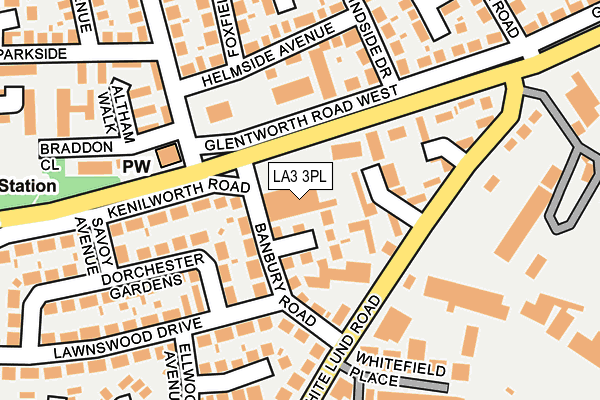
LA3 3PL is located in the Westgate electoral ward, within the local authority district of Lancaster and the English Parliamentary constituency of Morecambe and Lunesdale. The Sub Integrated Care Board (ICB) Location is NHS Lancashire and South Cumbria ICB - 01K and the police force is Lancashire. This postcode has been in use since September 2012.


GetTheData
Source: OS OpenMap – Local (Ordnance Survey)
Source: OS VectorMap District (Ordnance Survey)
Licence: Open Government Licence (requires attribution)
| Easting | 344261 |
| Northing | 463065 |
| Latitude | 54.060502 |
| Longitude | -2.853046 |
GetTheData
Source: Open Postcode Geo
Licence: Open Government Licence
| Country | England |
| Postcode District | LA3 |
| ➜ LA3 open data dashboard ➜ See where LA3 is on a map ➜ Where is Morecambe? | |
GetTheData
Source: Land Registry Price Paid Data
Licence: Open Government Licence
Elevation or altitude of LA3 3PL as distance above sea level:
| Metres | Feet | |
|---|---|---|
| Elevation | 10m | 33ft |
Elevation is measured from the approximate centre of the postcode, to the nearest point on an OS contour line from OS Terrain 50, which has contour spacing of ten vertical metres.
➜ How high above sea level am I? Find the elevation of your current position using your device's GPS.
GetTheData
Source: Open Postcode Elevation
Licence: Open Government Licence
| Ward | Westgate |
| Constituency | Morecambe And Lunesdale |
GetTheData
Source: ONS Postcode Database
Licence: Open Government Licence
| January 2024 | Violence and sexual offences | On or near Lindsay Court | 342m |
| January 2024 | Violence and sexual offences | On or near Riverview Court | 415m |
| January 2024 | Anti-social behaviour | On or near Riverview Court | 415m |
| ➜ Get more crime data in our Crime section | |||
GetTheData
Source: data.police.uk
Licence: Open Government Licence
| William Mitchell (Westgate) | Westgate | 72m |
| William Mitchell (Altham Road) | Westgate | 143m |
| White Lund Road (Westgate) | Westgate | 154m |
| William Mitchell (Westgate) | Westgate | 154m |
| Altham Road | Westgate | 169m |
| Morecambe Station | 1.5km |
| Bare Lane Station | 1.9km |
| Lancaster Station | 3.3km |
GetTheData
Source: NaPTAN
Licence: Open Government Licence
GetTheData
Source: ONS Postcode Database
Licence: Open Government Licence


➜ Get more ratings from the Food Standards Agency
GetTheData
Source: Food Standards Agency
Licence: FSA terms & conditions
| Last Collection | |||
|---|---|---|---|
| Location | Mon-Fri | Sat | Distance |
| Westgate Post Office | 17:00 | 11:45 | 106m |
| Grindley Road | 16:45 | 11:45 | 442m |
| Minster Drive | 16:00 | 11:00 | 523m |
GetTheData
Source: Dracos
Licence: Creative Commons Attribution-ShareAlike
| Facility | Distance |
|---|---|
| Ironmasters Gym Whitefield Place, Morecambe Health and Fitness Gym | 240m |
| Westgate Primary School Langridge Way, Morecambe Grass Pitches | 544m |
| The Trimpell Club Out Moss Lane, Morecambe Grass Pitches, Sports Hall | 893m |
GetTheData
Source: Active Places
Licence: Open Government Licence
| School | Phase of Education | Distance |
|---|---|---|
| Morecambe and Heysham Westgate Primary School Langridge Way, Westgate, Westgate Primary School, Morecambe, LA4 4XF | Primary | 543m |
| Lancaster Road Primary School Lancaster Road, Morecambe, LA4 5TH | Primary | 951m |
| Morecambe Road School Morecambe Road, Morecambe, LA3 3AB | Not applicable | 1.3km |
GetTheData
Source: Edubase
Licence: Open Government Licence
| Risk of LA3 3PL flooding from rivers and sea | Low |
| ➜ LA3 3PL flood map | |
GetTheData
Source: Open Flood Risk by Postcode
Licence: Open Government Licence
The below table lists the International Territorial Level (ITL) codes (formerly Nomenclature of Territorial Units for Statistics (NUTS) codes) and Local Administrative Units (LAU) codes for LA3 3PL:
| ITL 1 Code | Name |
|---|---|
| TLD | North West (England) |
| ITL 2 Code | Name |
| TLD4 | Lancashire |
| ITL 3 Code | Name |
| TLD44 | Lancaster and Wyre |
| LAU 1 Code | Name |
| E07000121 | Lancaster |
GetTheData
Source: ONS Postcode Directory
Licence: Open Government Licence
The below table lists the Census Output Area (OA), Lower Layer Super Output Area (LSOA), and Middle Layer Super Output Area (MSOA) for LA3 3PL:
| Code | Name | |
|---|---|---|
| OA | E00127747 | |
| LSOA | E01025172 | Lancaster 010C |
| MSOA | E02005230 | Lancaster 010 |
GetTheData
Source: ONS Postcode Directory
Licence: Open Government Licence
| LA3 3LX | Broughton Grove | 48m |
| LA3 3NJ | Banbury Road | 80m |
| LA3 3DJ | Deanpoint | 90m |
| LA3 3LR | Dorchester Gardens | 114m |
| LA3 3LW | Kenilworth Road | 124m |
| LA4 4SZ | Glentworth Road West | 130m |
| LA3 3LT | Lawnswood Drive | 142m |
| LA4 4SX | Helmside Avenue | 169m |
| LA3 3NL | White Lund Road | 169m |
| LA3 3NH | Ashbourne Grove | 176m |
GetTheData
Source: Open Postcode Geo; Land Registry Price Paid Data
Licence: Open Government Licence