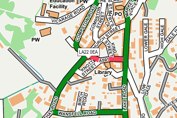
LA22 0EA is located in the Windermere and Ambleside electoral ward, within the unitary authority of Westmorland and Furness and the English Parliamentary constituency of Westmorland and Lonsdale. The Sub Integrated Care Board (ICB) Location is NHS Lancashire and South Cumbria ICB - 01K and the police force is Cumbria. This postcode has been in use since January 1980.


GetTheData
Source: OS OpenMap – Local (Ordnance Survey)
Source: OS VectorMap District (Ordnance Survey)
Licence: Open Government Licence (requires attribution)
| Easting | 337543 |
| Northing | 504264 |
| Latitude | 54.429946 |
| Longitude | -2.964263 |
GetTheData
Source: Open Postcode Geo
Licence: Open Government Licence
| Country | England |
| Postcode District | LA22 |
| ➜ LA22 open data dashboard ➜ See where LA22 is on a map ➜ Where is Ambleside? | |
GetTheData
Source: Land Registry Price Paid Data
Licence: Open Government Licence
Elevation or altitude of LA22 0EA as distance above sea level:
| Metres | Feet | |
|---|---|---|
| Elevation | 50m | 164ft |
Elevation is measured from the approximate centre of the postcode, to the nearest point on an OS contour line from OS Terrain 50, which has contour spacing of ten vertical metres.
➜ How high above sea level am I? Find the elevation of your current position using your device's GPS.
GetTheData
Source: Open Postcode Elevation
Licence: Open Government Licence
| Ward | Windermere And Ambleside |
| Constituency | Westmorland And Lonsdale |
GetTheData
Source: ONS Postcode Database
Licence: Open Government Licence
| November 2023 | Violence and sexual offences | On or near St Mary'S Lane | 170m |
| November 2023 | Violence and sexual offences | On or near St Mary'S Lane | 170m |
| March 2023 | Violence and sexual offences | On or near St Mary'S Lane | 170m |
| ➜ Get more crime data in our Crime section | |||
GetTheData
Source: data.police.uk
Licence: Open Government Licence
| Bus Interchange (Kelsick Road) | Ambleside | 46m |
| Bus Interchange (Kelsick Road) | Ambleside | 66m |
| Loughrigg Avenue (Lake Road) | Ambleside | 271m |
| Salutation Hotel (Lake Road) | Ambleside | 280m |
| Rydal Road Bowling Green (Rydal Road) | Ambleside | 324m |
GetTheData
Source: NaPTAN
Licence: Open Government Licence
GetTheData
Source: ONS Postcode Database
Licence: Open Government Licence


➜ Get more ratings from the Food Standards Agency
GetTheData
Source: Food Standards Agency
Licence: FSA terms & conditions
| Last Collection | |||
|---|---|---|---|
| Location | Mon-Fri | Sat | Distance |
| Lake Road, Ambleside | 17:00 | 11:45 | 123m |
| Millans Park | 17:00 | 11:45 | 200m |
| Rothay Bridge | 17:00 | 11:45 | 290m |
GetTheData
Source: Dracos
Licence: Creative Commons Attribution-ShareAlike
| Facility | Distance |
|---|---|
| White Platts Recreation Ground Compston Road, Ambleside Outdoor Tennis Courts | 110m |
| Hillard Park Rothay Road, Ambleside Grass Pitches | 303m |
| Rothay Park Millans Park, Ambleside Grass Pitches | 316m |
GetTheData
Source: Active Places
Licence: Open Government Licence
| School | Phase of Education | Distance |
|---|---|---|
| Ambleside CofE Primary School Vicarage Road, Ambleside, LA22 9DH | Primary | 187m |
| Windermere School Browhead, Patterdale Road, Windermere, The Lake District, LA23 1NW | Not applicable | 2.9km |
| Grasmere CofE Primary School Stock Lane, Grasmere, Ambleside, LA22 9SJ | Primary | 4.8km |
GetTheData
Source: Edubase
Licence: Open Government Licence
| Risk of LA22 0EA flooding from rivers and sea | Medium |
| ➜ LA22 0EA flood map | |
GetTheData
Source: Open Flood Risk by Postcode
Licence: Open Government Licence
The below table lists the International Territorial Level (ITL) codes (formerly Nomenclature of Territorial Units for Statistics (NUTS) codes) and Local Administrative Units (LAU) codes for LA22 0EA:
| ITL 1 Code | Name |
|---|---|
| TLD | North West (England) |
| ITL 2 Code | Name |
| TLD1 | Cumbria |
| ITL 3 Code | Name |
| TLD12 | East Cumbria |
| LAU 1 Code | Name |
| E07000031 | South Lakeland |
GetTheData
Source: ONS Postcode Directory
Licence: Open Government Licence
The below table lists the Census Output Area (OA), Lower Layer Super Output Area (LSOA), and Middle Layer Super Output Area (MSOA) for LA22 0EA:
| Code | Name | |
|---|---|---|
| OA | E00097951 | |
| LSOA | E01019374 | South Lakeland 001A |
| MSOA | E02004015 | South Lakeland 001 |
GetTheData
Source: ONS Postcode Directory
Licence: Open Government Licence
| LA22 9DL | Cambridge Villas | 28m |
| LA22 0BT | Church Street | 52m |
| LA22 0RB | Reed Bottoms | 80m |
| LA22 0BZ | Kelsick Road | 82m |
| LA22 0BP | Kelsick Court | 93m |
| LA22 0BX | King Street | 96m |
| LA22 9DJ | Compston Road | 107m |
| LA22 0BU | Church Street | 110m |
| LA22 9DP | Compston Street | 122m |
| LA22 0DB | Lake Road | 125m |
GetTheData
Source: Open Postcode Geo; Land Registry Price Paid Data
Licence: Open Government Licence