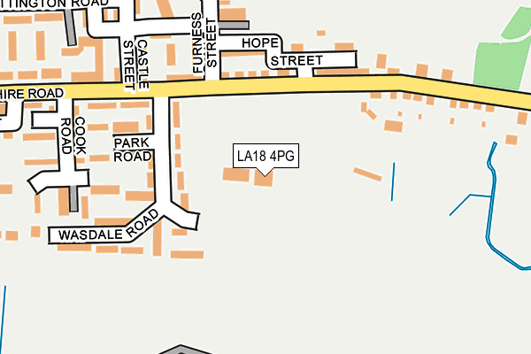
LA18 4PG is located in the Millom electoral ward, within the unitary authority of Cumberland and the English Parliamentary constituency of Copeland. The Sub Integrated Care Board (ICB) Location is NHS Lancashire and South Cumbria ICB - 01K and the police force is Cumbria. This postcode has been in use since January 1983.


GetTheData
Source: OS OpenMap – Local (Ordnance Survey)
Source: OS VectorMap District (Ordnance Survey)
Licence: Open Government Licence (requires attribution)
| Easting | 317915 |
| Northing | 479712 |
| Latitude | 54.206552 |
| Longitude | -3.259990 |
GetTheData
Source: Open Postcode Geo
Licence: Open Government Licence
| Country | England |
| Postcode District | LA18 |
| ➜ LA18 open data dashboard ➜ See where LA18 is on a map ➜ Where is Millom? | |
GetTheData
Source: Land Registry Price Paid Data
Licence: Open Government Licence
Elevation or altitude of LA18 4PG as distance above sea level:
| Metres | Feet | |
|---|---|---|
| Elevation | 10m | 33ft |
Elevation is measured from the approximate centre of the postcode, to the nearest point on an OS contour line from OS Terrain 50, which has contour spacing of ten vertical metres.
➜ How high above sea level am I? Find the elevation of your current position using your device's GPS.
GetTheData
Source: Open Postcode Elevation
Licence: Open Government Licence
| Ward | Millom |
| Constituency | Copeland |
GetTheData
Source: ONS Postcode Database
Licence: Open Government Licence
| October 2023 | Violence and sexual offences | On or near Parking Area | 427m |
| June 2022 | Burglary | On or near Sports/Recreation Area | 110m |
| June 2022 | Criminal damage and arson | On or near Park Road | 164m |
| ➜ Get more crime data in our Crime section | |||
GetTheData
Source: data.police.uk
Licence: Open Government Licence
| Market Square | Millom | 722m |
| Rail Station (Station Road) | Millom | 890m |
| Rail Station (Station Road) | Millom | 900m |
| Horn Hill | Millom | 943m |
| Station Road (St George's Road) | Millom | 957m |
| Millom Station | 0.9km |
| Askam Station | 4.1km |
| Green Road Station | 4.3km |
GetTheData
Source: NaPTAN
Licence: Open Government Licence
GetTheData
Source: ONS Postcode Database
Licence: Open Government Licence


➜ Get more ratings from the Food Standards Agency
GetTheData
Source: Food Standards Agency
Licence: FSA terms & conditions
| Last Collection | |||
|---|---|---|---|
| Location | Mon-Fri | Sat | Distance |
| Furness Street | 16:45 | 10:30 | 141m |
| Lapstone Road | 16:45 | 10:30 | 475m |
| Lonsdale Road | 16:45 | 10:45 | 564m |
GetTheData
Source: Dracos
Licence: Creative Commons Attribution-ShareAlike
| Facility | Distance |
|---|---|
| Millom Rugby League Football Club Devonshire Road, Millom Grass Pitches, Health and Fitness Gym | 0m |
| Millom St James Albert Street, Millom Grass Pitches | 367m |
| Saint James Catholic Primary School Lonsdale Road, Millom Grass Pitches | 537m |
GetTheData
Source: Active Places
Licence: Open Government Licence
| School | Phase of Education | Distance |
|---|---|---|
| Millom Infant School Lapstone Road, Millom Infant School, Millom, LA18 4LP | Primary | 495m |
| St James' Catholic Primary School Lonsdale Road, Lonsdale Road, Millom, millom, LA18 4AS | Primary | 536m |
| Parkview Nursery School St. Georges Road, Millom, LA18 4LE | Nursery | 855m |
GetTheData
Source: Edubase
Licence: Open Government Licence
| Risk of LA18 4PG flooding from rivers and sea | Low |
| ➜ LA18 4PG flood map | |
GetTheData
Source: Open Flood Risk by Postcode
Licence: Open Government Licence
The below table lists the International Territorial Level (ITL) codes (formerly Nomenclature of Territorial Units for Statistics (NUTS) codes) and Local Administrative Units (LAU) codes for LA18 4PG:
| ITL 1 Code | Name |
|---|---|
| TLD | North West (England) |
| ITL 2 Code | Name |
| TLD1 | Cumbria |
| ITL 3 Code | Name |
| TLD11 | West Cumbria |
| LAU 1 Code | Name |
| E07000029 | Copeland |
GetTheData
Source: ONS Postcode Directory
Licence: Open Government Licence
The below table lists the Census Output Area (OA), Lower Layer Super Output Area (LSOA), and Middle Layer Super Output Area (MSOA) for LA18 4PG:
| Code | Name | |
|---|---|---|
| OA | E00097539 | |
| LSOA | E01019298 | Copeland 008F |
| MSOA | E02004007 | Copeland 008 |
GetTheData
Source: ONS Postcode Directory
Licence: Open Government Licence
| LA18 4JP | Devonshire Road | 131m |
| LA18 4JJ | Wasdale Road | 139m |
| LA18 4JW | Hope Street | 143m |
| LA18 4JL | Park Road | 176m |
| LA18 4JN | Bedford Street | 188m |
| LA18 4LW | Devonshire Road | 230m |
| LA18 4JH | Cook Road | 239m |
| LA18 4DX | Castle Street | 240m |
| LA18 4DU | Windsor Street | 260m |
| LA18 4DT | Newton Street | 262m |
GetTheData
Source: Open Postcode Geo; Land Registry Price Paid Data
Licence: Open Government Licence