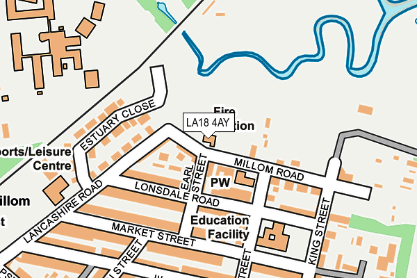
LA18 4AY is located in the Millom electoral ward, within the unitary authority of Cumberland and the English Parliamentary constituency of Copeland. The Sub Integrated Care Board (ICB) Location is NHS Lancashire and South Cumbria ICB - 01K and the police force is Cumbria. This postcode has been in use since January 1980.


GetTheData
Source: OS OpenMap – Local (Ordnance Survey)
Source: OS VectorMap District (Ordnance Survey)
Licence: Open Government Licence (requires attribution)
| Easting | 317684 |
| Northing | 480293 |
| Latitude | 54.211744 |
| Longitude | -3.263690 |
GetTheData
Source: Open Postcode Geo
Licence: Open Government Licence
| Country | England |
| Postcode District | LA18 |
| ➜ LA18 open data dashboard ➜ See where LA18 is on a map ➜ Where is Millom? | |
GetTheData
Source: Land Registry Price Paid Data
Licence: Open Government Licence
Elevation or altitude of LA18 4AY as distance above sea level:
| Metres | Feet | |
|---|---|---|
| Elevation | 10m | 33ft |
Elevation is measured from the approximate centre of the postcode, to the nearest point on an OS contour line from OS Terrain 50, which has contour spacing of ten vertical metres.
➜ How high above sea level am I? Find the elevation of your current position using your device's GPS.
GetTheData
Source: Open Postcode Elevation
Licence: Open Government Licence
| Ward | Millom |
| Constituency | Copeland |
GetTheData
Source: ONS Postcode Database
Licence: Open Government Licence
| October 2023 | Violence and sexual offences | On or near Parking Area | 227m |
| June 2022 | Violence and sexual offences | On or near Katherine Street | 274m |
| June 2022 | Violence and sexual offences | On or near Katherine Street | 274m |
| ➜ Get more crime data in our Crime section | |||
GetTheData
Source: data.police.uk
Licence: Open Government Licence
| School (Salthouse Road) | Millom | 465m |
| Market Square | Millom | 477m |
| Rail Station (Station Road) | Millom | 480m |
| Rail Station (Station Road) | Millom | 487m |
| Huddleston Road (Salthouse Road) | Millom | 492m |
| Millom Station | 0.5km |
| Green Road Station | 3.8km |
| Askam Station | 4.6km |
GetTheData
Source: NaPTAN
Licence: Open Government Licence
GetTheData
Source: ONS Postcode Database
Licence: Open Government Licence


➜ Get more ratings from the Food Standards Agency
GetTheData
Source: Food Standards Agency
Licence: FSA terms & conditions
| Last Collection | |||
|---|---|---|---|
| Location | Mon-Fri | Sat | Distance |
| Lonsdale Road | 16:45 | 10:45 | 68m |
| Millom Delivery Office | 17:30 | 11:15 | 403m |
| Lapstone Road | 16:45 | 10:30 | 486m |
GetTheData
Source: Dracos
Licence: Creative Commons Attribution-ShareAlike
| Facility | Distance |
|---|---|
| Saint James Catholic Primary School Lonsdale Road, Millom Grass Pitches | 97m |
| Millom St James Albert Street, Millom Grass Pitches | 321m |
| Millom Recreation Centre Lancashire Road, Millom Sports Hall, Health and Fitness Gym | 321m |
GetTheData
Source: Active Places
Licence: Open Government Licence
| School | Phase of Education | Distance |
|---|---|---|
| St James' Catholic Primary School Lonsdale Road, Lonsdale Road, Millom, millom, LA18 4AS | Primary | 96m |
| Millom School Salthouse Road, Millom, LA18 5AB | Secondary | 408m |
| Millom Infant School Lapstone Road, Millom Infant School, Millom, LA18 4LP | Primary | 477m |
GetTheData
Source: Edubase
Licence: Open Government Licence
| Risk of LA18 4AY flooding from rivers and sea | Low |
| ➜ LA18 4AY flood map | |
GetTheData
Source: Open Flood Risk by Postcode
Licence: Open Government Licence
The below table lists the International Territorial Level (ITL) codes (formerly Nomenclature of Territorial Units for Statistics (NUTS) codes) and Local Administrative Units (LAU) codes for LA18 4AY:
| ITL 1 Code | Name |
|---|---|
| TLD | North West (England) |
| ITL 2 Code | Name |
| TLD1 | Cumbria |
| ITL 3 Code | Name |
| TLD11 | West Cumbria |
| LAU 1 Code | Name |
| E07000029 | Copeland |
GetTheData
Source: ONS Postcode Directory
Licence: Open Government Licence
The below table lists the Census Output Area (OA), Lower Layer Super Output Area (LSOA), and Middle Layer Super Output Area (MSOA) for LA18 4AY:
| Code | Name | |
|---|---|---|
| OA | E00097534 | |
| LSOA | E01019299 | Copeland 008G |
| MSOA | E02004007 | Copeland 008 |
GetTheData
Source: ONS Postcode Directory
Licence: Open Government Licence
| LA18 4AZ | Millom Road | 35m |
| LA18 4AS | Lonsdale Road | 73m |
| LA18 4BA | King Street | 83m |
| LA18 4AR | Lonsdale Road | 89m |
| LA18 4AT | Lonsdale Terrace | 97m |
| LA18 4AU | Earl Street | 105m |
| LA18 4BG | Queen Street | 110m |
| LA18 4AX | Earl Street | 158m |
| LA18 4AL | Market Street | 160m |
| LA18 4AJ | Market Street | 168m |
GetTheData
Source: Open Postcode Geo; Land Registry Price Paid Data
Licence: Open Government Licence