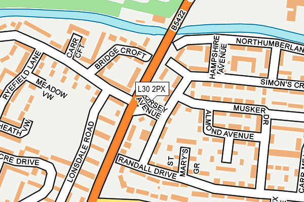
L30 2PX is located in the Ford electoral ward, within the metropolitan district of Sefton and the English Parliamentary constituency of Bootle. The Sub Integrated Care Board (ICB) Location is NHS Cheshire and Merseyside ICB - 01T and the police force is Merseyside. This postcode has been in use since January 1980.


GetTheData
Source: OS OpenMap – Local (Ordnance Survey)
Source: OS VectorMap District (Ordnance Survey)
Licence: Open Government Licence (requires attribution)
| Easting | 334128 |
| Northing | 399109 |
| Latitude | 53.484556 |
| Longitude | -2.994150 |
GetTheData
Source: Open Postcode Geo
Licence: Open Government Licence
| Country | England |
| Postcode District | L30 |
| ➜ L30 open data dashboard ➜ See where L30 is on a map ➜ Where is Bootle? | |
GetTheData
Source: Land Registry Price Paid Data
Licence: Open Government Licence
Elevation or altitude of L30 2PX as distance above sea level:
| Metres | Feet | |
|---|---|---|
| Elevation | 20m | 66ft |
Elevation is measured from the approximate centre of the postcode, to the nearest point on an OS contour line from OS Terrain 50, which has contour spacing of ten vertical metres.
➜ How high above sea level am I? Find the elevation of your current position using your device's GPS.
GetTheData
Source: Open Postcode Elevation
Licence: Open Government Licence
| Ward | Ford |
| Constituency | Bootle |
GetTheData
Source: ONS Postcode Database
Licence: Open Government Licence
| January 2024 | Anti-social behaviour | On or near Randall Drive | 39m |
| January 2024 | Other theft | On or near Randall Drive | 39m |
| December 2023 | Anti-social behaviour | On or near Randall Drive | 39m |
| ➜ Get more crime data in our Crime section | |||
GetTheData
Source: data.police.uk
Licence: Open Government Licence
| Gorsey Avenue (Gorsey Lane) | Ford | 29m |
| Lonsdale Road (Ford Lane) | Ford | 110m |
| Bridge Croft (Ford Lane) | Ford | 124m |
| Randall Drive (Gorsey Lane) | Ford | 127m |
| Green Lane (Gorsey Lane) | Ford | 296m |
| Seaforth & Litherland Station | 2.2km |
| Waterloo (Merseyside) Station | 2.3km |
| Aintree Station | 2.8km |
GetTheData
Source: NaPTAN
Licence: Open Government Licence
| Percentage of properties with Next Generation Access | 100.0% |
| Percentage of properties with Superfast Broadband | 100.0% |
| Percentage of properties with Ultrafast Broadband | 100.0% |
| Percentage of properties with Full Fibre Broadband | 0.0% |
Superfast Broadband is between 30Mbps and 300Mbps
Ultrafast Broadband is > 300Mbps
| Percentage of properties unable to receive 2Mbps | 0.0% |
| Percentage of properties unable to receive 5Mbps | 0.0% |
| Percentage of properties unable to receive 10Mbps | 0.0% |
| Percentage of properties unable to receive 30Mbps | 0.0% |
GetTheData
Source: Ofcom
Licence: Ofcom Terms of Use (requires attribution)
GetTheData
Source: ONS Postcode Database
Licence: Open Government Licence


➜ Get more ratings from the Food Standards Agency
GetTheData
Source: Food Standards Agency
Licence: FSA terms & conditions
| Last Collection | |||
|---|---|---|---|
| Location | Mon-Fri | Sat | Distance |
| Gorsey Avenue | 17:00 | 12:00 | 53m |
| Sterrix Lane | 17:00 | 12:00 | 343m |
| Poulsom Drive | 17:00 | 12:00 | 493m |
GetTheData
Source: Dracos
Licence: Creative Commons Attribution-ShareAlike
| Facility | Distance |
|---|---|
| Litherland High School (Closed) Sterrix Lane, Liverpool Grass Pitches, Sports Hall, Health and Fitness Gym | 707m |
| South Sefton College Sterrix Lane, Bootle Sports Hall, Studio, Grass Pitches | 717m |
| Hatton Hill Primary School Alwyn Avenue, Liverpool Grass Pitches | 726m |
GetTheData
Source: Active Places
Licence: Open Government Licence
| School | Phase of Education | Distance |
|---|---|---|
| IMPACT Daleacre Campus, Daleacre Drive, Bootle, Liverpool, L30 2QQ | Not applicable | 409m |
| Our Lady Queen of Peace Catholic Primary School Ford Close, Litherland, Liverpool, L21 0EP | Primary | 611m |
| Litherland High School Sterrix Lane, Litherland, Liverpool, L21 0DB | Secondary | 707m |
GetTheData
Source: Edubase
Licence: Open Government Licence
The below table lists the International Territorial Level (ITL) codes (formerly Nomenclature of Territorial Units for Statistics (NUTS) codes) and Local Administrative Units (LAU) codes for L30 2PX:
| ITL 1 Code | Name |
|---|---|
| TLD | North West (England) |
| ITL 2 Code | Name |
| TLD7 | Merseyside |
| ITL 3 Code | Name |
| TLD73 | Sefton |
| LAU 1 Code | Name |
| E08000014 | Sefton |
GetTheData
Source: ONS Postcode Directory
Licence: Open Government Licence
The below table lists the Census Output Area (OA), Lower Layer Super Output Area (LSOA), and Middle Layer Super Output Area (MSOA) for L30 2PX:
| Code | Name | |
|---|---|---|
| OA | E00035896 | |
| LSOA | E01007089 | Sefton 024E |
| MSOA | E02001452 | Sefton 024 |
GetTheData
Source: ONS Postcode Directory
Licence: Open Government Licence
| L30 2PT | Gorsey Lane | 48m |
| L30 2RX | Simons Croft | 55m |
| L21 0DQ | Gorsey Lane | 57m |
| L30 2RS | Simons Croft | 64m |
| L21 0HP | Ford Lane | 74m |
| L30 2PB | Randall Drive | 75m |
| L30 2QA | St Michaels Grove | 97m |
| L30 2PH | St Marys Grove | 100m |
| L21 0HJ | Bridge Croft | 110m |
| L30 2PS | Gorsey Lane | 114m |
GetTheData
Source: Open Postcode Geo; Land Registry Price Paid Data
Licence: Open Government Licence