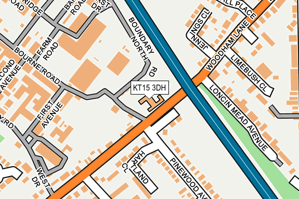
KT15 3DH is located in the New Haw electoral ward, within the local authority district of Runnymede and the English Parliamentary constituency of Runnymede and Weybridge. The Sub Integrated Care Board (ICB) Location is NHS Surrey Heartlands ICB - 92A and the police force is Surrey. This postcode has been in use since March 2009.


GetTheData
Source: OS OpenMap – Local (Ordnance Survey)
Source: OS VectorMap District (Ordnance Survey)
Licence: Open Government Licence (requires attribution)
| Easting | 505119 |
| Northing | 162641 |
| Latitude | 51.353131 |
| Longitude | -0.491835 |
GetTheData
Source: Open Postcode Geo
Licence: Open Government Licence
| Country | England |
| Postcode District | KT15 |
| ➜ KT15 open data dashboard ➜ See where KT15 is on a map ➜ Where is New Haw? | |
GetTheData
Source: Land Registry Price Paid Data
Licence: Open Government Licence
Elevation or altitude of KT15 3DH as distance above sea level:
| Metres | Feet | |
|---|---|---|
| Elevation | 20m | 66ft |
Elevation is measured from the approximate centre of the postcode, to the nearest point on an OS contour line from OS Terrain 50, which has contour spacing of ten vertical metres.
➜ How high above sea level am I? Find the elevation of your current position using your device's GPS.
GetTheData
Source: Open Postcode Elevation
Licence: Open Government Licence
| Ward | New Haw |
| Constituency | Runnymede And Weybridge |
GetTheData
Source: ONS Postcode Database
Licence: Open Government Licence
| June 2022 | Public order | On or near Jennings Close | 153m |
| June 2022 | Public order | On or near Limebush Close | 205m |
| June 2022 | Anti-social behaviour | On or near Limebush Close | 205m |
| ➜ Get more crime data in our Crime section | |||
GetTheData
Source: data.police.uk
Licence: Open Government Licence
| Pinewood Avenue (Woodham Lane) | Woodham | 38m |
| Pinewood Avenue (Woodham Lane) | Woodham | 40m |
| Marshall Place (Woodham Lane) | New Haw | 220m |
| Marshall Place (Woodham Lane) | New Haw | 296m |
| Mayfield Avenue | Woodham | 346m |
| Byfleet & New Haw Station | 0.8km |
| West Byfleet Station | 1.8km |
| Addlestone Station | 2.3km |
GetTheData
Source: NaPTAN
Licence: Open Government Licence
GetTheData
Source: ONS Postcode Database
Licence: Open Government Licence


➜ Get more ratings from the Food Standards Agency
GetTheData
Source: Food Standards Agency
Licence: FSA terms & conditions
| Last Collection | |||
|---|---|---|---|
| Location | Mon-Fri | Sat | Distance |
| Pinewood Avenue | 17:15 | 11:00 | 53m |
| Parkside | 17:15 | 11:00 | 564m |
| 2 Woodham Lane | 17:15 | 11:30 | 573m |
GetTheData
Source: Dracos
Licence: Creative Commons Attribution-ShareAlike
| Facility | Distance |
|---|---|
| Heathervale Recreation Ground Parkside, New Haw, Addlestone Grass Pitches, Outdoor Tennis Courts | 651m |
| Topgolf Surrey Moated Farm Drive, Addlestone Health and Fitness Gym, Golf | 727m |
| New Haw Community Junior School The Avenue, New Haw, Addlestone Grass Pitches | 1.1km |
GetTheData
Source: Active Places
Licence: Open Government Licence
| School | Phase of Education | Distance |
|---|---|---|
| The Grange Community Infant School The Avenue, New Haw, Addlestone, KT15 3RL | Primary | 1km |
| New Haw Community Junior School The Avenue, New Haw, Addlestone, KT15 3RL | Primary | 1.1km |
| Byfleet Primary School King's Head Lane, Byfleet, West Byfleet, KT14 7AT | Primary | 1.2km |
GetTheData
Source: Edubase
Licence: Open Government Licence
| Risk of KT15 3DH flooding from rivers and sea | Medium |
| ➜ KT15 3DH flood map | |
GetTheData
Source: Open Flood Risk by Postcode
Licence: Open Government Licence
The below table lists the International Territorial Level (ITL) codes (formerly Nomenclature of Territorial Units for Statistics (NUTS) codes) and Local Administrative Units (LAU) codes for KT15 3DH:
| ITL 1 Code | Name |
|---|---|
| TLJ | South East (England) |
| ITL 2 Code | Name |
| TLJ2 | Surrey, East and West Sussex |
| ITL 3 Code | Name |
| TLJ25 | West Surrey |
| LAU 1 Code | Name |
| E07000212 | Runnymede |
GetTheData
Source: ONS Postcode Directory
Licence: Open Government Licence
The below table lists the Census Output Area (OA), Lower Layer Super Output Area (LSOA), and Middle Layer Super Output Area (MSOA) for KT15 3DH:
| Code | Name | |
|---|---|---|
| OA | E00156467 | |
| LSOA | E01030683 | Runnymede 010C |
| MSOA | E02006402 | Runnymede 010 |
GetTheData
Source: ONS Postcode Directory
Licence: Open Government Licence
| KT15 3NG | Woodham Lane | 67m |
| KT15 3NE | Woodham Lane | 132m |
| KT15 3AD | Hartland Close | 134m |
| KT15 3AA | Pinewood Avenue | 144m |
| KT15 3NQ | Woodham Lane | 145m |
| KT15 3NL | Hawthorn Way | 203m |
| KT15 3PZ | Jenning Close | 204m |
| KT15 3LW | Limebush Close | 208m |
| KT15 3NJ | Woodham Lane | 222m |
| KT15 3ND | Woodham Lane | 230m |
GetTheData
Source: Open Postcode Geo; Land Registry Price Paid Data
Licence: Open Government Licence