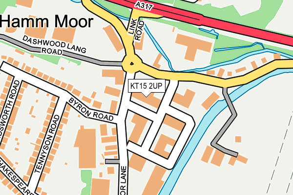
KT15 2UP is located in the Addlestone South electoral ward, within the local authority district of Runnymede and the English Parliamentary constituency of Runnymede and Weybridge. The Sub Integrated Care Board (ICB) Location is NHS Surrey Heartlands ICB - 92A and the police force is Surrey. This postcode has been in use since July 1990.


GetTheData
Source: OS OpenMap – Local (Ordnance Survey)
Source: OS VectorMap District (Ordnance Survey)
Licence: Open Government Licence (requires attribution)
| Easting | 506276 |
| Northing | 164717 |
| Latitude | 51.371576 |
| Longitude | -0.474606 |
GetTheData
Source: Open Postcode Geo
Licence: Open Government Licence
| Country | England |
| Postcode District | KT15 |
| ➜ KT15 open data dashboard ➜ See where KT15 is on a map ➜ Where is Addlestone? | |
GetTheData
Source: Land Registry Price Paid Data
Licence: Open Government Licence
Elevation or altitude of KT15 2UP as distance above sea level:
| Metres | Feet | |
|---|---|---|
| Elevation | 20m | 66ft |
Elevation is measured from the approximate centre of the postcode, to the nearest point on an OS contour line from OS Terrain 50, which has contour spacing of ten vertical metres.
➜ How high above sea level am I? Find the elevation of your current position using your device's GPS.
GetTheData
Source: Open Postcode Elevation
Licence: Open Government Licence
| Ward | Addlestone South |
| Constituency | Runnymede And Weybridge |
GetTheData
Source: ONS Postcode Database
Licence: Open Government Licence
| June 2022 | Public order | On or near Byron Road | 177m |
| June 2022 | Criminal damage and arson | On or near Byron Road | 177m |
| June 2022 | Violence and sexual offences | On or near Byron Road | 177m |
| ➜ Get more crime data in our Crime section | |||
GetTheData
Source: data.police.uk
Licence: Open Government Licence
| Meadowlands Park (Weybridge Road) | Ham Moor | 173m |
| Meadowlands Park (Weybridge Road) | Ham Moor | 192m |
| St Georges College (Weybridge Road) | Addlestone | 407m |
| St Georges College (Weybridge Road) | Addlestone | 416m |
| Aviator Park (Station Road) | Addlestone | 591m |
| Addlestone Station | 0.7km |
| Weybridge Station | 1.6km |
| Byfleet & New Haw Station | 2.5km |
GetTheData
Source: NaPTAN
Licence: Open Government Licence
GetTheData
Source: ONS Postcode Database
Licence: Open Government Licence


➜ Get more ratings from the Food Standards Agency
GetTheData
Source: Food Standards Agency
Licence: FSA terms & conditions
| Last Collection | |||
|---|---|---|---|
| Location | Mon-Fri | Sat | Distance |
| Hamm Moor Lane | 17:30 | 12:30 | 81m |
| Meadowlands | 17:30 | 12:00 | 204m |
| Bourneside Road | 17:15 | 12:30 | 480m |
GetTheData
Source: Dracos
Licence: Creative Commons Attribution-ShareAlike
| Facility | Distance |
|---|---|
| St Georges Weybridge Weybridge Road, Addlestone Sports Hall, Indoor Tennis Centre, Artificial Grass Pitch, Athletics, Grass Pitches, Outdoor Tennis Courts, Health and Fitness Gym | 738m |
| Aviator Park Pyle Close, Addlestone Grass Pitches | 818m |
| Weybridge Hall (Closed) Church Street, Weybridge Sports Hall | 971m |
GetTheData
Source: Active Places
Licence: Open Government Licence
| School | Phase of Education | Distance |
|---|---|---|
| St George's College Weybridge Weybridge Road, Addlestone, KT15 2QS | Not applicable | 744m |
| St Charles Borromeo Catholic Primary School, Weybridge Portmore Way, Weybridge, KT13 8JD | Primary | 994m |
| Heathside School Brooklands Lane, Weybridge, KT13 8UZ | Secondary | 1km |
GetTheData
Source: Edubase
Licence: Open Government Licence
| Risk of KT15 2UP flooding from rivers and sea | Low |
| ➜ KT15 2UP flood map | |
GetTheData
Source: Open Flood Risk by Postcode
Licence: Open Government Licence
The below table lists the International Territorial Level (ITL) codes (formerly Nomenclature of Territorial Units for Statistics (NUTS) codes) and Local Administrative Units (LAU) codes for KT15 2UP:
| ITL 1 Code | Name |
|---|---|
| TLJ | South East (England) |
| ITL 2 Code | Name |
| TLJ2 | Surrey, East and West Sussex |
| ITL 3 Code | Name |
| TLJ25 | West Surrey |
| LAU 1 Code | Name |
| E07000212 | Runnymede |
GetTheData
Source: ONS Postcode Directory
Licence: Open Government Licence
The below table lists the Census Output Area (OA), Lower Layer Super Output Area (LSOA), and Middle Layer Super Output Area (MSOA) for KT15 2UP:
| Code | Name | |
|---|---|---|
| OA | E00156296 | |
| LSOA | E01030647 | Runnymede 007A |
| MSOA | E02006399 | Runnymede 007 |
GetTheData
Source: ONS Postcode Directory
Licence: Open Government Licence
| KT15 2SX | Byron Road | 71m |
| KT15 2SA | 95m | |
| KT15 2RX | Addlestone Road | 141m |
| KT15 2SD | Hamm Moor Lane | 199m |
| KT15 2SJ | Byron Road | 223m |
| KT15 2SP | Tennyson Road | 230m |
| KT15 2SW | Wordsworth Road | 277m |
| KT15 2ST | Shakespeare Road | 292m |
| KT15 2QX | Church Cottages | 314m |
| KT15 2SS | Shakespeare Road | 316m |
GetTheData
Source: Open Postcode Geo; Land Registry Price Paid Data
Licence: Open Government Licence