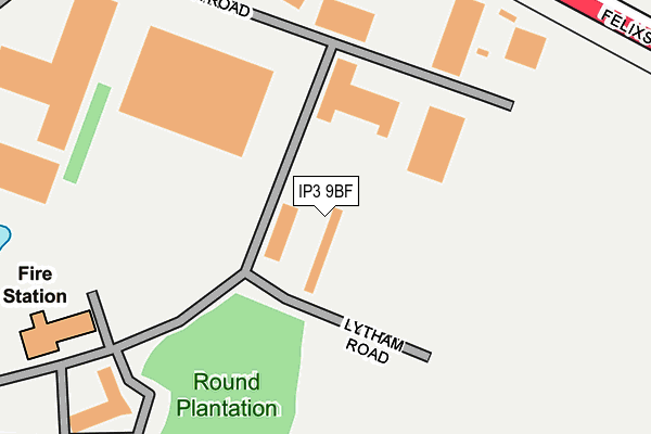
IP3 9BF is located in the Priory Heath electoral ward, within the local authority district of Ipswich and the English Parliamentary constituency of Ipswich. The Sub Integrated Care Board (ICB) Location is NHS Suffolk and North East Essex ICB - 06L and the police force is Suffolk. This postcode has been in use since February 2009.


GetTheData
Source: OS OpenMap – Local (Ordnance Survey)
Source: OS VectorMap District (Ordnance Survey)
Licence: Open Government Licence (requires attribution)
| Easting | 621027 |
| Northing | 241517 |
| Latitude | 52.028014 |
| Longitude | 1.220541 |
GetTheData
Source: Open Postcode Geo
Licence: Open Government Licence
| Country | England |
| Postcode District | IP3 |
| ➜ IP3 open data dashboard ➜ See where IP3 is on a map ➜ Where is Ipswich? | |
GetTheData
Source: Land Registry Price Paid Data
Licence: Open Government Licence
Elevation or altitude of IP3 9BF as distance above sea level:
| Metres | Feet | |
|---|---|---|
| Elevation | 30m | 98ft |
Elevation is measured from the approximate centre of the postcode, to the nearest point on an OS contour line from OS Terrain 50, which has contour spacing of ten vertical metres.
➜ How high above sea level am I? Find the elevation of your current position using your device's GPS.
GetTheData
Source: Open Postcode Elevation
Licence: Open Government Licence
| Ward | Priory Heath |
| Constituency | Ipswich |
GetTheData
Source: ONS Postcode Database
Licence: Open Government Licence
| June 2022 | Public order | On or near Parking Area | 446m |
| June 2022 | Public order | On or near The Havens | 448m |
| June 2022 | Public order | On or near The Havens | 448m |
| ➜ Get more crime data in our Crime section | |||
GetTheData
Source: data.police.uk
Licence: Open Government Licence
| Lytham Road (The Havens) | Ransomes Europark | 149m |
| Makro (Wentworth Road) | Ransomes Europark | 194m |
| Mercedes Garage | Ransomes Europark | 369m |
| Carter Builder | Ransomes Europark | 415m |
| Parcel Force | Ransomes Europark | 475m |
| Derby Road (Ipswich) Station | 3.6km |
GetTheData
Source: NaPTAN
Licence: Open Government Licence
GetTheData
Source: ONS Postcode Database
Licence: Open Government Licence


➜ Get more ratings from the Food Standards Agency
GetTheData
Source: Food Standards Agency
Licence: FSA terms & conditions
| Last Collection | |||
|---|---|---|---|
| Location | Mon-Fri | Sat | Distance |
| Shepherd & Dog P/H | 17:15 | 11:30 | 703m |
| Murrels Road | 17:30 | 12:00 | 896m |
| 44 Felix Road | 17:15 | 12:00 | 927m |
GetTheData
Source: Dracos
Licence: Creative Commons Attribution-ShareAlike
| Facility | Distance |
|---|---|
| David Lloyd (Ipswich) The Havens, Ransomes Europark, Ipswich Sports Hall, Swimming Pool, Health and Fitness Gym, Indoor Tennis Centre, Studio, Squash Courts, Outdoor Tennis Courts | 512m |
| Civil Service Sports Ground (Closed) Straight Road, Bucklesham, Ipswich Grass Pitches | 1.2km |
| Nacton Sports Ground The Street, Nacton, Ipswich Grass Pitches, Outdoor Tennis Courts | 1.4km |
GetTheData
Source: Active Places
Licence: Open Government Licence
| School | Phase of Education | Distance |
|---|---|---|
| New Skill Centre Wolsey House, 2-5 The Drift, Nacton Road, Ipswich, IP3 9QR | Not applicable | 1.7km |
| Nacton Church of England Primary School The Street, Nacton, Ipswich, IP10 0EU | Primary | 1.8km |
| Ravenswood Community Primary School Ravenswood Avenue, Ipswich, IP3 9UA | Primary | 1.8km |
GetTheData
Source: Edubase
Licence: Open Government Licence
The below table lists the International Territorial Level (ITL) codes (formerly Nomenclature of Territorial Units for Statistics (NUTS) codes) and Local Administrative Units (LAU) codes for IP3 9BF:
| ITL 1 Code | Name |
|---|---|
| TLH | East |
| ITL 2 Code | Name |
| TLH1 | East Anglia |
| ITL 3 Code | Name |
| TLH14 | Suffolk CC |
| LAU 1 Code | Name |
| E07000202 | Ipswich |
GetTheData
Source: ONS Postcode Directory
Licence: Open Government Licence
The below table lists the Census Output Area (OA), Lower Layer Super Output Area (LSOA), and Middle Layer Super Output Area (MSOA) for IP3 9BF:
| Code | Name | |
|---|---|---|
| OA | E00170860 | |
| LSOA | E01033127 | Ipswich 014E |
| MSOA | E02006258 | Ipswich 014 |
GetTheData
Source: ONS Postcode Directory
Licence: Open Government Licence
| IP3 9GU | Edison Close | 203m |
| IP3 9SJ | The Havens | 444m |
| IP10 0DF | Felixstowe Road | 479m |
| IP3 9RR | Bluestem Road | 607m |
| IP3 8UX | Penny Lane | 625m |
| IP10 0DG | Elmham Drive | 656m |
| IP3 8UY | Porter Road | 665m |
| IP3 8UZ | Routh Avenue | 677m |
| IP3 8UT | Mill Road Drive | 742m |
| IP3 8US | Murrills Road | 776m |
GetTheData
Source: Open Postcode Geo; Land Registry Price Paid Data
Licence: Open Government Licence