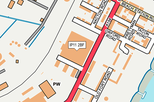
IP11 2BF is located in the Eastern Felixstowe electoral ward, within the local authority district of East Suffolk and the English Parliamentary constituency of Suffolk Coastal. The Sub Integrated Care Board (ICB) Location is NHS Suffolk and North East Essex ICB - 06L and the police force is Suffolk. This postcode has been in use since August 2014.


GetTheData
Source: OS OpenMap – Local (Ordnance Survey)
Source: OS VectorMap District (Ordnance Survey)
Licence: Open Government Licence (requires attribution)
| Easting | 628978 |
| Northing | 233054 |
| Latitude | 51.948833 |
| Longitude | 1.330589 |
GetTheData
Source: Open Postcode Geo
Licence: Open Government Licence
| Country | England |
| Postcode District | IP11 |
| ➜ IP11 open data dashboard ➜ See where IP11 is on a map ➜ Where is Felixstowe? | |
GetTheData
Source: Land Registry Price Paid Data
Licence: Open Government Licence
Elevation or altitude of IP11 2BF as distance above sea level:
| Metres | Feet | |
|---|---|---|
| Elevation | 10m | 33ft |
Elevation is measured from the approximate centre of the postcode, to the nearest point on an OS contour line from OS Terrain 50, which has contour spacing of ten vertical metres.
➜ How high above sea level am I? Find the elevation of your current position using your device's GPS.
GetTheData
Source: Open Postcode Elevation
Licence: Open Government Licence
| Ward | Eastern Felixstowe |
| Constituency | Suffolk Coastal |
GetTheData
Source: ONS Postcode Database
Licence: Open Government Licence
| June 2022 | Criminal damage and arson | On or near Carr Road | 144m |
| June 2022 | Other theft | On or near Adastral Close | 301m |
| June 2022 | Anti-social behaviour | On or near Manor Terrace | 302m |
| ➜ Get more crime data in our Crime section | |||
GetTheData
Source: data.police.uk
Licence: Open Government Licence
| Haven Caravan Park (Carr Road) | Felixstowe Dock | 92m |
| Manor Road (Langer Road) | Felixstowe Dock | 94m |
| Manor Road (Langer Road) | Felixstowe Dock | 98m |
| Haven Caravan Park (Carr Road) | Felixstowe Dock | 103m |
| Tacon Road (Langer Road) | Felixstowe | 445m |
| Felixstowe Station | 2.4km |
| Harwich Town Station | 3.1km |
| Trimley Station | 3.2km |
GetTheData
Source: NaPTAN
Licence: Open Government Licence
GetTheData
Source: ONS Postcode Database
Licence: Open Government Licence


➜ Get more ratings from the Food Standards Agency
GetTheData
Source: Food Standards Agency
Licence: FSA terms & conditions
| Last Collection | |||
|---|---|---|---|
| Location | Mon-Fri | Sat | Distance |
| Arwela Road | 17:30 | 12:00 | 947m |
| Bent Hill Post Office | 17:30 | 12:30 | 1,916m |
| Church Street Post Office | 17:15 | 11:30 | 2,964m |
GetTheData
Source: Dracos
Licence: Creative Commons Attribution-ShareAlike
| Facility | Distance |
|---|---|
| Felixstowe Leisure Centre Undercliff Road West, Felixstowe Indoor Bowls, Swimming Pool, Health and Fitness Gym, Sports Hall, Studio | 1.4km |
| Coronation Sports Ground Mill Lane, Felixstowe Grass Pitches | 1.5km |
| Anytime Fitness (Felixstowe) Ferry Lane, Ferry Lane, Felixstowe Health and Fitness Gym | 1.7km |
GetTheData
Source: Active Places
Licence: Open Government Licence
| School | Phase of Education | Distance |
|---|---|---|
| Langer Primary Academy Langer Road, Felixstowe, IP11 2HL | Primary | 708m |
| Grange Community Primary School Grange Road, Felixstowe, IP11 2LA | Primary | 1.7km |
| Set Felix Maidstone Road, Felixstowe, IP11 9ED | Primary | 2.6km |
GetTheData
Source: Edubase
Licence: Open Government Licence
| Risk of IP11 2BF flooding from rivers and sea | Low |
| ➜ IP11 2BF flood map | |
GetTheData
Source: Open Flood Risk by Postcode
Licence: Open Government Licence
The below table lists the International Territorial Level (ITL) codes (formerly Nomenclature of Territorial Units for Statistics (NUTS) codes) and Local Administrative Units (LAU) codes for IP11 2BF:
| ITL 1 Code | Name |
|---|---|
| TLH | East |
| ITL 2 Code | Name |
| TLH1 | East Anglia |
| ITL 3 Code | Name |
| TLH14 | Suffolk CC |
| LAU 1 Code | Name |
| E07000244 | East Suffolk |
GetTheData
Source: ONS Postcode Directory
Licence: Open Government Licence
The below table lists the Census Output Area (OA), Lower Layer Super Output Area (LSOA), and Middle Layer Super Output Area (MSOA) for IP11 2BF:
| Code | Name | |
|---|---|---|
| OA | E00153798 | |
| LSOA | E01030163 | Suffolk Coastal 015B |
| MSOA | E02006301 | Suffolk Coastal 015 |
GetTheData
Source: ONS Postcode Directory
Licence: Open Government Licence
| IP11 2EJ | Manor Road | 205m |
| IP11 2JB | Summit Business Park | 209m |
| IP11 2EN | Manor Terrace | 225m |
| IP11 2GF | Old Fort Road | 237m |
| IP11 3BQ | Schneider Close | 241m |
| IP11 2GD | Manor Terrace | 260m |
| IP11 3SS | Schneider Close | 262m |
| IP11 2ED | Langer Road | 263m |
| IP11 2GE | Manor Terrace | 269m |
| IP11 2GJ | Marine Parade Walk | 282m |
GetTheData
Source: Open Postcode Geo; Land Registry Price Paid Data
Licence: Open Government Licence