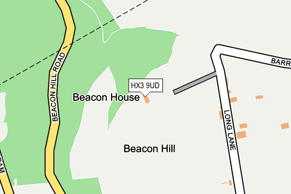
HX3 9UD lies on Long Lane in Southowram, Halifax. HX3 9UD is located in the Town electoral ward, within the metropolitan district of Calderdale and the English Parliamentary constituency of Halifax. The Sub Integrated Care Board (ICB) Location is NHS West Yorkshire ICB - 02T and the police force is West Yorkshire. This postcode has been in use since January 1980.


GetTheData
Source: OS OpenMap – Local (Ordnance Survey)
Source: OS VectorMap District (Ordnance Survey)
Licence: Open Government Licence (requires attribution)
| Easting | 410514 |
| Northing | 425182 |
| Latitude | 53.722955 |
| Longitude | -1.842143 |
GetTheData
Source: Open Postcode Geo
Licence: Open Government Licence
| Street | Long Lane |
| Locality | Southowram |
| Town/City | Halifax |
| Country | England |
| Postcode District | HX3 |
| ➜ HX3 open data dashboard ➜ See where HX3 is on a map | |
GetTheData
Source: Land Registry Price Paid Data
Licence: Open Government Licence
Elevation or altitude of HX3 9UD as distance above sea level:
| Metres | Feet | |
|---|---|---|
| Elevation | 260m | 853ft |
Elevation is measured from the approximate centre of the postcode, to the nearest point on an OS contour line from OS Terrain 50, which has contour spacing of ten vertical metres.
➜ How high above sea level am I? Find the elevation of your current position using your device's GPS.
GetTheData
Source: Open Postcode Elevation
Licence: Open Government Licence
| Ward | Town |
| Constituency | Halifax |
GetTheData
Source: ONS Postcode Database
Licence: Open Government Licence
| Beacon Hill Rd Southowram Bank (Beacon Hill Road) | Halifax Town Centre | 481m |
| Beacon Hill Rd Southowram Bank (Beacon Hill Road) | Halifax Town Centre | 483m |
| Beacon Hill Rd Green Lane (Beacon Hill Road) | Halifax Town Centre | 523m |
| Beacon Hill Rd Green Lane (Beacon Hill Road) | Halifax Town Centre | 534m |
| Beacon Hill Road Godley Branch Rd (Beacon Hill Road) | Claremount | 593m |
| Halifax Station | 0.8km |
| Sowerby Bridge Station | 4.6km |
| Brighouse Station | 5km |
GetTheData
Source: NaPTAN
Licence: Open Government Licence
| Percentage of properties with Next Generation Access | 100.0% |
| Percentage of properties with Superfast Broadband | 100.0% |
| Percentage of properties with Ultrafast Broadband | 0.0% |
| Percentage of properties with Full Fibre Broadband | 0.0% |
Superfast Broadband is between 30Mbps and 300Mbps
Ultrafast Broadband is > 300Mbps
| Percentage of properties unable to receive 2Mbps | 0.0% |
| Percentage of properties unable to receive 5Mbps | 0.0% |
| Percentage of properties unable to receive 10Mbps | 0.0% |
| Percentage of properties unable to receive 30Mbps | 0.0% |
GetTheData
Source: Ofcom
Licence: Ofcom Terms of Use (requires attribution)
GetTheData
Source: ONS Postcode Database
Licence: Open Government Licence


➜ Get more ratings from the Food Standards Agency
GetTheData
Source: Food Standards Agency
Licence: FSA terms & conditions
| Last Collection | |||
|---|---|---|---|
| Location | Mon-Fri | Sat | Distance |
| Halifax Railway Station | 18:30 | 12:30 | 811m |
| Whitegate Road | 17:15 | 11:45 | 856m |
| Halifax Delivery Office | 19:30 | 12:30 | 1,018m |
GetTheData
Source: Dracos
Licence: Creative Commons Attribution-ShareAlike
| Facility | Distance |
|---|---|
| Long Lane Long Lane, Southowram, Halifax Grass Pitches | 227m |
| Everlast Gyms (Halifax) Charlestown Road, Halifax Swimming Pool, Health and Fitness Gym, Studio | 743m |
| Snap Fitness (Halifax) (Closed) Charles Street, Charles Street, Halifax Health and Fitness Gym | 852m |
GetTheData
Source: Active Places
Licence: Open Government Licence
| School | Phase of Education | Distance |
|---|---|---|
| St Joseph's Catholic Primary Academy Portland Road, Halifax, HX3 6LA | Primary | 1.1km |
| Trinity Sixth Form Academy Northgate House, Halifax, HX1 1UN | 16 plus | 1.1km |
| Withinfields Primary School Withinfields, Southowram, Halifax, HX3 9QJ | Primary | 1.3km |
GetTheData
Source: Edubase
Licence: Open Government Licence
The below table lists the International Territorial Level (ITL) codes (formerly Nomenclature of Territorial Units for Statistics (NUTS) codes) and Local Administrative Units (LAU) codes for HX3 9UD:
| ITL 1 Code | Name |
|---|---|
| TLE | Yorkshire and The Humber |
| ITL 2 Code | Name |
| TLE4 | West Yorkshire |
| ITL 3 Code | Name |
| TLE44 | Calderdale and Kirklees |
| LAU 1 Code | Name |
| E08000033 | Calderdale |
GetTheData
Source: ONS Postcode Directory
Licence: Open Government Licence
The below table lists the Census Output Area (OA), Lower Layer Super Output Area (LSOA), and Middle Layer Super Output Area (MSOA) for HX3 9UD:
| Code | Name | |
|---|---|---|
| OA | E00055410 | |
| LSOA | E01010991 | Calderdale 018C |
| MSOA | E02002261 | Calderdale 018 |
GetTheData
Source: ONS Postcode Directory
Licence: Open Government Licence
| HX3 9PZ | Beacon Hill Road | 445m |
| HX3 9XL | Southowram Bank | 487m |
| HX3 9UE | Marsh Delves | 513m |
| HX3 9NX | The Crescent | 520m |
| HX3 9XW | Bailey Hall View | 543m |
| HX3 9NW | Le Mar View | 561m |
| HX3 9PU | Southowram Bank | 571m |
| HX3 9NU | Long Lane | 572m |
| HX3 9PT | Blaithroyd Court | 575m |
| HX3 9XP | Baldwin Terrace | 577m |
GetTheData
Source: Open Postcode Geo; Land Registry Price Paid Data
Licence: Open Government Licence