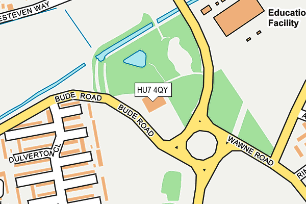
HU7 4QY is located in the Kingswood electoral ward, within the unitary authority of Kingston upon Hull, City of and the English Parliamentary constituency of Kingston upon Hull North. The Sub Integrated Care Board (ICB) Location is NHS Humber and North Yorkshire ICB - 03F and the police force is Humberside. This postcode has been in use since March 2016.


GetTheData
Source: OS OpenMap – Local (Ordnance Survey)
Source: OS VectorMap District (Ordnance Survey)
Licence: Open Government Licence (requires attribution)
| Easting | 510097 |
| Northing | 434758 |
| Latitude | 53.797508 |
| Longitude | -0.329969 |
GetTheData
Source: Open Postcode Geo
Licence: Open Government Licence
| Country | England |
| Postcode District | HU7 |
| ➜ HU7 open data dashboard ➜ See where HU7 is on a map ➜ Where is Kingston upon Hull? | |
GetTheData
Source: Land Registry Price Paid Data
Licence: Open Government Licence
Elevation or altitude of HU7 4QY as distance above sea level:
| Metres | Feet | |
|---|---|---|
| Elevation | 0m | 0ft |
Elevation is measured from the approximate centre of the postcode, to the nearest point on an OS contour line from OS Terrain 50, which has contour spacing of ten vertical metres.
➜ How high above sea level am I? Find the elevation of your current position using your device's GPS.
GetTheData
Source: Open Postcode Elevation
Licence: Open Government Licence
| Ward | Kingswood |
| Constituency | Kingston Upon Hull North |
GetTheData
Source: ONS Postcode Database
Licence: Open Government Licence
| June 2022 | Violence and sexual offences | On or near Wawne Road | 224m |
| June 2022 | Anti-social behaviour | On or near Wawne Road | 224m |
| June 2022 | Violence and sexual offences | On or near Wawne Road | 224m |
| ➜ Get more crime data in our Crime section | |||
GetTheData
Source: data.police.uk
Licence: Open Government Licence
| Foredyke Bridge (Wawne Road) | North Bransholme | 165m |
| Foredyke Bridge (Wawne Road) | North Bransholme | 207m |
| Abingdon Garth (Noddle Hill Way) | Noddle Hill | 260m |
| Sedgebrook Grove (Kesteven Way) | Kingswood | 261m |
| Quarrington Grove (Kesteven Way) | Kingswood | 269m |
| Cottingham Station | 5.3km |
GetTheData
Source: NaPTAN
Licence: Open Government Licence
GetTheData
Source: ONS Postcode Database
Licence: Open Government Licence


➜ Get more ratings from the Food Standards Agency
GetTheData
Source: Food Standards Agency
Licence: FSA terms & conditions
| Last Collection | |||
|---|---|---|---|
| Location | Mon-Fri | Sat | Distance |
| Kesteven Way Hull | 16:45 | 11:30 | 281m |
| Bodmin Road Post Office | 16:45 | 11:30 | 591m |
| Digby Garth | 17:00 | 12:30 | 715m |
GetTheData
Source: Dracos
Licence: Creative Commons Attribution-ShareAlike
| Facility | Distance |
|---|---|
| Kingswood Academy Wawne Road, Bransholme, Hull Grass Pitches, Sports Hall, Studio, Health and Fitness Gym, Artificial Grass Pitch | 241m |
| Northcott School Dulverton Close, Bransholme, Hull Grass Pitches, Sports Hall | 337m |
| Zeals Garth Pos Haydock Garth, Bransholme, Hull Grass Pitches | 670m |
GetTheData
Source: Active Places
Licence: Open Government Licence
| School | Phase of Education | Distance |
|---|---|---|
| Kingswood Academy Wawne Road, Bransholme, Hull, HU7 4WR | Secondary | 268m |
| Northcott School and Sixth Form College Northcott School, Bransholme, Hull, HU7 4EL | Not applicable | 293m |
| Cleeve Primary School Wawne Road, Bransholme, Hull, HU7 4JH | Primary | 704m |
GetTheData
Source: Edubase
Licence: Open Government Licence
| Risk of HU7 4QY flooding from rivers and sea | Low |
| ➜ HU7 4QY flood map | |
GetTheData
Source: Open Flood Risk by Postcode
Licence: Open Government Licence
The below table lists the International Territorial Level (ITL) codes (formerly Nomenclature of Territorial Units for Statistics (NUTS) codes) and Local Administrative Units (LAU) codes for HU7 4QY:
| ITL 1 Code | Name |
|---|---|
| TLE | Yorkshire and The Humber |
| ITL 2 Code | Name |
| TLE1 | East Yorkshire and Northern Lincolnshire |
| ITL 3 Code | Name |
| TLE11 | Kingston upon Hull, City of |
| LAU 1 Code | Name |
| E06000010 | Kingston upon Hull, City of |
GetTheData
Source: ONS Postcode Directory
Licence: Open Government Licence
The below table lists the Census Output Area (OA), Lower Layer Super Output Area (LSOA), and Middle Layer Super Output Area (MSOA) for HU7 4QY:
| Code | Name | |
|---|---|---|
| OA | E00064710 | |
| LSOA | E01012832 | Kingston upon Hull 001E |
| MSOA | E02002652 | Kingston upon Hull 001 |
GetTheData
Source: ONS Postcode Directory
Licence: Open Government Licence
| HU7 4EH | Dulverton Close | 157m |
| HU7 4EJ | Dulverton Close | 195m |
| HU7 4EN | Dulverton Close | 255m |
| HU7 4EL | Dulverton Close | 293m |
| HU7 3EB | Sedgebrook Grove | 300m |
| HU7 3DY | Quarrington Grove | 316m |
| HU7 4LA | Abingdon Garth | 349m |
| HU7 4EP | Exton Close | 363m |
| HU7 3EN | Langley Park | 367m |
| HU7 3DX | Navenby Grove | 370m |
GetTheData
Source: Open Postcode Geo; Land Registry Price Paid Data
Licence: Open Government Licence