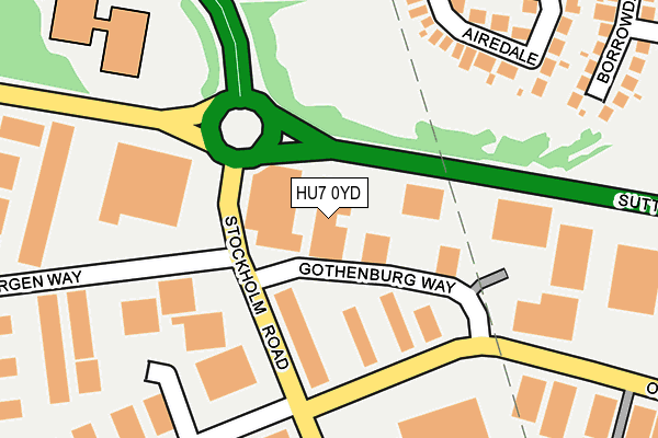
HU7 0YD is located in the Holderness electoral ward, within the unitary authority of Kingston upon Hull, City of and the English Parliamentary constituency of Kingston upon Hull East. The Sub Integrated Care Board (ICB) Location is NHS Humber and North Yorkshire ICB - 03F and the police force is Humberside. This postcode has been in use since August 1992.


GetTheData
Source: OS OpenMap – Local (Ordnance Survey)
Source: OS VectorMap District (Ordnance Survey)
Licence: Open Government Licence (requires attribution)
| Easting | 509340 |
| Northing | 432724 |
| Latitude | 53.779374 |
| Longitude | -0.342170 |
GetTheData
Source: Open Postcode Geo
Licence: Open Government Licence
| Country | England |
| Postcode District | HU7 |
| ➜ HU7 open data dashboard ➜ See where HU7 is on a map ➜ Where is Kingston upon Hull? | |
GetTheData
Source: Land Registry Price Paid Data
Licence: Open Government Licence
Elevation or altitude of HU7 0YD as distance above sea level:
| Metres | Feet | |
|---|---|---|
| Elevation | 0m | 0ft |
Elevation is measured from the approximate centre of the postcode, to the nearest point on an OS contour line from OS Terrain 50, which has contour spacing of ten vertical metres.
➜ How high above sea level am I? Find the elevation of your current position using your device's GPS.
GetTheData
Source: Open Postcode Elevation
Licence: Open Government Licence
| Ward | Holderness |
| Constituency | Kingston Upon Hull East |
GetTheData
Source: ONS Postcode Database
Licence: Open Government Licence
| January 2024 | Public order | On or near Airedale | 250m |
| January 2024 | Burglary | On or near The Willows | 307m |
| January 2024 | Burglary | On or near The Willows | 307m |
| ➜ Get more crime data in our Crime section | |||
GetTheData
Source: data.police.uk
Licence: Open Government Licence
| Bergen Way (Stockholm Road) | Sutton Park | 101m |
| Ennerdale Leisure Centre (Sutton Road) | Sutton Park | 192m |
| Ennerdale Leisure Centre (Sutton Road) | Sutton Park | 211m |
| Thomas Clarkson Way (Ennerdale) | Sutton Park | 244m |
| Grandale (Littondale) | Sutton Park | 434m |
| Hull Station | 3.9km |
| Cottingham Station | 4.2km |
GetTheData
Source: NaPTAN
Licence: Open Government Licence
GetTheData
Source: ONS Postcode Database
Licence: Open Government Licence


➜ Get more ratings from the Food Standards Agency
GetTheData
Source: Food Standards Agency
Licence: FSA terms & conditions
| Last Collection | |||
|---|---|---|---|
| Location | Mon-Fri | Sat | Distance |
| Royal Mail Hull | 19:30 | 13:30 | 193m |
| Malmo Road | 19:30 | 379m | |
| Grandale Post Office | 16:45 | 11:15 | 488m |
GetTheData
Source: Dracos
Licence: Creative Commons Attribution-ShareAlike
| Facility | Distance |
|---|---|
| Ennerdale Leisure Centre Ennerdale, Hull Sports Hall, Swimming Pool, Health and Fitness Gym, Studio, Cycling | 250m |
| Ennerdale Playing Fields Welwyn Park Avenue, Hull Grass Pitches | 638m |
| St Andrews Ce Primary School Grandale, Hull Grass Pitches | 724m |
GetTheData
Source: Active Places
Licence: Open Government Licence
| School | Phase of Education | Distance |
|---|---|---|
| Sutton Park Primary School Marsdale, Sutton Park, Kingston-upon-Hull, HU7 4AH | Primary | 573m |
| St Andrew's Church of England Voluntary Aided Primary School Grandale, Sutton Park, Hull, HU7 4BL | Primary | 597m |
| St Mary Queen of Martyrs VC Academy Nidderdale, Sutton Park, Hull, HU7 4BS | Primary | 989m |
GetTheData
Source: Edubase
Licence: Open Government Licence
| Risk of HU7 0YD flooding from rivers and sea | Medium |
| ➜ HU7 0YD flood map | |
GetTheData
Source: Open Flood Risk by Postcode
Licence: Open Government Licence
The below table lists the International Territorial Level (ITL) codes (formerly Nomenclature of Territorial Units for Statistics (NUTS) codes) and Local Administrative Units (LAU) codes for HU7 0YD:
| ITL 1 Code | Name |
|---|---|
| TLE | Yorkshire and The Humber |
| ITL 2 Code | Name |
| TLE1 | East Yorkshire and Northern Lincolnshire |
| ITL 3 Code | Name |
| TLE11 | Kingston upon Hull, City of |
| LAU 1 Code | Name |
| E06000010 | Kingston upon Hull, City of |
GetTheData
Source: ONS Postcode Directory
Licence: Open Government Licence
The below table lists the Census Output Area (OA), Lower Layer Super Output Area (LSOA), and Middle Layer Super Output Area (MSOA) for HU7 0YD:
| Code | Name | |
|---|---|---|
| OA | E00064660 | |
| LSOA | E01012817 | Kingston upon Hull 016D |
| MSOA | E02002667 | Kingston upon Hull 016 |
GetTheData
Source: ONS Postcode Directory
Licence: Open Government Licence
| HU7 0YG | Gothenburg Way | 92m |
| HU7 6DT | Airedale | 236m |
| HU7 4WG | Oxford Violet | 243m |
| HU7 0YR | Oslo Road | 277m |
| HU7 4WH | The Willows | 285m |
| HU7 6DR | Borrowdale | 330m |
| HU7 4WJ | Salix Court | 367m |
| HU7 0YF | Malmo Road | 369m |
| HU7 4WF | Flanders Red | 372m |
| HU7 4AD | Cotterdale | 394m |
GetTheData
Source: Open Postcode Geo; Land Registry Price Paid Data
Licence: Open Government Licence