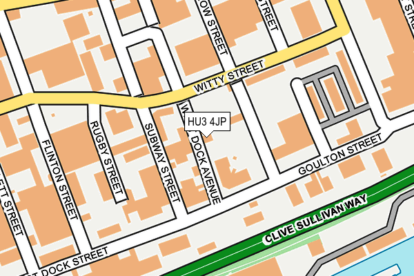
HU3 4JP is located in the St Andrew's & Docklands electoral ward, within the unitary authority of Kingston upon Hull, City of and the English Parliamentary constituency of Kingston upon Hull West and Hessle. The Sub Integrated Care Board (ICB) Location is NHS Humber and North Yorkshire ICB - 03F and the police force is Humberside. This postcode has been in use since January 1980.


GetTheData
Source: OS OpenMap – Local (Ordnance Survey)
Source: OS VectorMap District (Ordnance Survey)
Licence: Open Government Licence (requires attribution)
| Easting | 507929 |
| Northing | 427498 |
| Latitude | 53.732736 |
| Longitude | -0.365403 |
GetTheData
Source: Open Postcode Geo
Licence: Open Government Licence
| Country | England |
| Postcode District | HU3 |
| ➜ HU3 open data dashboard ➜ See where HU3 is on a map ➜ Where is Kingston upon Hull? | |
GetTheData
Source: Land Registry Price Paid Data
Licence: Open Government Licence
Elevation or altitude of HU3 4JP as distance above sea level:
| Metres | Feet | |
|---|---|---|
| Elevation | 0m | 0ft |
Elevation is measured from the approximate centre of the postcode, to the nearest point on an OS contour line from OS Terrain 50, which has contour spacing of ten vertical metres.
➜ How high above sea level am I? Find the elevation of your current position using your device's GPS.
GetTheData
Source: Open Postcode Elevation
Licence: Open Government Licence
| Ward | St Andrew's & Docklands |
| Constituency | Kingston Upon Hull West And Hessle |
GetTheData
Source: ONS Postcode Database
Licence: Open Government Licence
| January 2024 | Shoplifting | On or near Parking Area | 249m |
| January 2024 | Criminal damage and arson | On or near Parking Area | 249m |
| January 2024 | Shoplifting | On or near Parking Area | 249m |
| ➜ Get more crime data in our Crime section | |||
GetTheData
Source: data.police.uk
Licence: Open Government Licence
| Rosamond Street (Hessle Road) | St Andrews | 241m |
| Eton Street (Hessle Road) | St Andrews | 247m |
| Dee Street (Hessle Road) | St Andrews | 301m |
| Flinton Street (Hessle Road) | St Andrews | 326m |
| Boulevard (Hessle Road) | St Andrews | 353m |
| Hull Station | 1.8km |
| New Holland Station | 3.4km |
| Barrow Haven Station | 4.3km |
GetTheData
Source: NaPTAN
Licence: Open Government Licence
GetTheData
Source: ONS Postcode Database
Licence: Open Government Licence


➜ Get more ratings from the Food Standards Agency
GetTheData
Source: Food Standards Agency
Licence: FSA terms & conditions
| Last Collection | |||
|---|---|---|---|
| Location | Mon-Fri | Sat | Distance |
| Goulton Street Hull | 17:30 | 12:30 | 155m |
| Hessle Road Post Office | 17:00 | 12:45 | 264m |
| Galliard Close Hull | 17:00 | 12:30 | 630m |
GetTheData
Source: Dracos
Licence: Creative Commons Attribution-ShareAlike
| Facility | Distance |
|---|---|
| Fit4gym (Hull) (Closed) Hessle Road, Kingston Upon Hull Health and Fitness Gym, Studio | 201m |
| Metro Gym Strickland Street, Hull Health and Fitness Gym, Studio | 491m |
| Newington Park (Massey Beecroft) Massey Street, Kingston Upon Hull Grass Pitches, Artificial Grass Pitch | 550m |
GetTheData
Source: Active Places
Licence: Open Government Licence
| School | Phase of Education | Distance |
|---|---|---|
| The Venn Boulevard Centre 172 Boulevard, Kingston-upon-Hull, HULL, HU3 3EL | Not applicable | 571m |
| Chiltern Primary School Chiltern Street, Hull, HU3 3PL | Primary | 660m |
| Newington Academy Dairycoates Avenue, Hull, HU3 5DD | Primary | 832m |
GetTheData
Source: Edubase
Licence: Open Government Licence
| Risk of HU3 4JP flooding from rivers and sea | Low |
| ➜ HU3 4JP flood map | |
GetTheData
Source: Open Flood Risk by Postcode
Licence: Open Government Licence
The below table lists the International Territorial Level (ITL) codes (formerly Nomenclature of Territorial Units for Statistics (NUTS) codes) and Local Administrative Units (LAU) codes for HU3 4JP:
| ITL 1 Code | Name |
|---|---|
| TLE | Yorkshire and The Humber |
| ITL 2 Code | Name |
| TLE1 | East Yorkshire and Northern Lincolnshire |
| ITL 3 Code | Name |
| TLE11 | Kingston upon Hull, City of |
| LAU 1 Code | Name |
| E06000010 | Kingston upon Hull, City of |
GetTheData
Source: ONS Postcode Directory
Licence: Open Government Licence
The below table lists the Census Output Area (OA), Lower Layer Super Output Area (LSOA), and Middle Layer Super Output Area (MSOA) for HU3 4JP:
| Code | Name | |
|---|---|---|
| OA | E00065040 | |
| LSOA | E01012889 | Kingston upon Hull 030B |
| MSOA | E02002681 | Kingston upon Hull 030 |
GetTheData
Source: ONS Postcode Directory
Licence: Open Government Licence
| HU3 4JR | West Dock Avenue | 102m |
| HU3 4EL | Subway Street | 118m |
| HU3 4DL | Goulton Street | 132m |
| HU3 4BJ | Hessle Road | 217m |
| HU3 4BL | Hessle Road | 228m |
| HU3 4BQ | Hessle Road | 230m |
| HU3 4NA | Flinton Street | 247m |
| HU3 3DU | Hessle Road | 247m |
| HU3 3SB | Hessle Road | 257m |
| HU3 4BN | Eton Street | 262m |
GetTheData
Source: Open Postcode Geo; Land Registry Price Paid Data
Licence: Open Government Licence