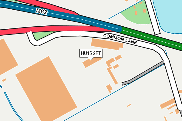
HU15 2FT is located in the Howdenshire electoral ward, within the unitary authority of East Riding of Yorkshire and the English Parliamentary constituency of Haltemprice and Howden. The Sub Integrated Care Board (ICB) Location is NHS Humber and North Yorkshire ICB - 02Y and the police force is Humberside. This postcode has been in use since February 2012.


GetTheData
Source: OS OpenMap – Local (Ordnance Survey)
Source: OS VectorMap District (Ordnance Survey)
Licence: Open Government Licence (requires attribution)
| Easting | 487756 |
| Northing | 431103 |
| Latitude | 53.768888 |
| Longitude | -0.670074 |
GetTheData
Source: Open Postcode Geo
Licence: Open Government Licence
| Country | England |
| Postcode District | HU15 |
| ➜ HU15 open data dashboard ➜ See where HU15 is on a map ➜ Where is Newport? | |
GetTheData
Source: Land Registry Price Paid Data
Licence: Open Government Licence
Elevation or altitude of HU15 2FT as distance above sea level:
| Metres | Feet | |
|---|---|---|
| Elevation | 10m | 33ft |
Elevation is measured from the approximate centre of the postcode, to the nearest point on an OS contour line from OS Terrain 50, which has contour spacing of ten vertical metres.
➜ How high above sea level am I? Find the elevation of your current position using your device's GPS.
GetTheData
Source: Open Postcode Elevation
Licence: Open Government Licence
| Ward | Howdenshire |
| Constituency | Haltemprice And Howden |
GetTheData
Source: ONS Postcode Database
Licence: Open Government Licence
| April 2022 | Burglary | On or near Common Lane | 305m |
| February 2022 | Violence and sexual offences | On or near Common Lane | 305m |
| September 2021 | Public order | On or near Common Lane | 305m |
| ➜ Get more crime data in our Crime section | |||
GetTheData
Source: data.police.uk
Licence: Open Government Licence
| A63 Common Lane (Common Lane) | North Cave | 241m |
| Newport Road B1230 (Newport Road) | Newport | 619m |
| Newport Stony Lane (Stony Lane) | Newport | 988m |
| North Cave Newport Road (Newport Road) | North Cave | 1,265m |
| North Cave Westgate (Westgate) | North Cave | 1,631m |
| Broomfleet Station | 3.2km |
| Gilberdyke Station | 4.7km |
GetTheData
Source: NaPTAN
Licence: Open Government Licence
GetTheData
Source: ONS Postcode Database
Licence: Open Government Licence


➜ Get more ratings from the Food Standards Agency
GetTheData
Source: Food Standards Agency
Licence: FSA terms & conditions
| Last Collection | |||
|---|---|---|---|
| Location | Mon-Fri | Sat | Distance |
| West End South Cave | 16:00 | 10:45 | 3,605m |
| White Acre 38 Main St Hotham | 17:15 | 09:05 | 3,701m |
| Broomfleet Post Office | 16:00 | 11:30 | 3,977m |
GetTheData
Source: Dracos
Licence: Creative Commons Attribution-ShareAlike
| Facility | Distance |
|---|---|
| North Cave Indoor Bowls Club Townend Lane, North Cave Indoor Bowls | 1.8km |
| Hmp Humber Sand Lane, North Cave Grass Pitches | 1.9km |
| North Cave Playing Fields Church Street, North Cave Grass Pitches | 2.4km |
GetTheData
Source: Active Places
Licence: Open Government Licence
| School | Phase of Education | Distance |
|---|---|---|
| North Cave Church of England Primary School Station Road, North Cave, BROUGH, HU15 2LA | Primary | 2km |
| Newport Primary School Main Road, Newport, Brough, HU15 2PP | Primary | 2.4km |
| South Cave Church of England Voluntary Controlled Primary School Church Street, South Cave, Brough, HU15 2EP | Primary | 4.1km |
GetTheData
Source: Edubase
Licence: Open Government Licence
| Risk of HU15 2FT flooding from rivers and sea | Low |
| ➜ HU15 2FT flood map | |
GetTheData
Source: Open Flood Risk by Postcode
Licence: Open Government Licence
The below table lists the International Territorial Level (ITL) codes (formerly Nomenclature of Territorial Units for Statistics (NUTS) codes) and Local Administrative Units (LAU) codes for HU15 2FT:
| ITL 1 Code | Name |
|---|---|
| TLE | Yorkshire and The Humber |
| ITL 2 Code | Name |
| TLE1 | East Yorkshire and Northern Lincolnshire |
| ITL 3 Code | Name |
| TLE12 | East Riding of Yorkshire |
| LAU 1 Code | Name |
| E06000011 | East Riding of Yorkshire |
GetTheData
Source: ONS Postcode Directory
Licence: Open Government Licence
The below table lists the Census Output Area (OA), Lower Layer Super Output Area (LSOA), and Middle Layer Super Output Area (MSOA) for HU15 2FT:
| Code | Name | |
|---|---|---|
| OA | E00065714 | |
| LSOA | E01013019 | East Riding of Yorkshire 026B |
| MSOA | E02002709 | East Riding of Yorkshire 026 |
GetTheData
Source: ONS Postcode Directory
Licence: Open Government Licence
| HU15 2PE | Common Lane | 105m |
| HU15 1RZ | A63 Westbound | 576m |
| HU15 2PF | Breck Lane | 631m |
| HU15 2PA | South Ings Lane | 700m |
| HU15 2FW | Innovation Drive | 867m |
| HU15 2RF | Wallingfen Lane | 926m |
| HU15 1RF | Wallingfen Lane | 1132m |
| HU15 2RH | Main Road | 1143m |
| HU15 2NY | Newport Road | 1226m |
| HU15 2NU | Newport Road | 1243m |
GetTheData
Source: Open Postcode Geo; Land Registry Price Paid Data
Licence: Open Government Licence