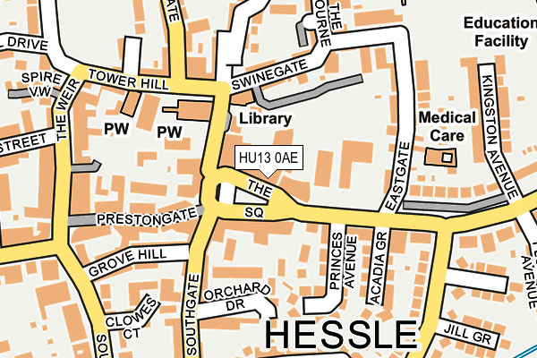
HU13 0AE lies on The Square in Hessle. HU13 0AE is located in the Hessle electoral ward, within the unitary authority of East Riding of Yorkshire and the English Parliamentary constituency of Kingston upon Hull West and Hessle. The Sub Integrated Care Board (ICB) Location is NHS Humber and North Yorkshire ICB - 02Y and the police force is Humberside. This postcode has been in use since January 1980.


GetTheData
Source: OS OpenMap – Local (Ordnance Survey)
Source: OS VectorMap District (Ordnance Survey)
Licence: Open Government Licence (requires attribution)
| Easting | 503394 |
| Northing | 426354 |
| Latitude | 53.723355 |
| Longitude | -0.434496 |
GetTheData
Source: Open Postcode Geo
Licence: Open Government Licence
| Street | The Square |
| Town/City | Hessle |
| Country | England |
| Postcode District | HU13 |
| ➜ HU13 open data dashboard ➜ See where HU13 is on a map ➜ Where is Hessle? | |
GetTheData
Source: Land Registry Price Paid Data
Licence: Open Government Licence
Elevation or altitude of HU13 0AE as distance above sea level:
| Metres | Feet | |
|---|---|---|
| Elevation | 10m | 33ft |
Elevation is measured from the approximate centre of the postcode, to the nearest point on an OS contour line from OS Terrain 50, which has contour spacing of ten vertical metres.
➜ How high above sea level am I? Find the elevation of your current position using your device's GPS.
GetTheData
Source: Open Postcode Elevation
Licence: Open Government Licence
| Ward | Hessle |
| Constituency | Kingston Upon Hull West And Hessle |
GetTheData
Source: ONS Postcode Database
Licence: Open Government Licence
| January 2024 | Shoplifting | On or near Parking Area | 83m |
| November 2023 | Violence and sexual offences | On or near Parking Area | 83m |
| November 2023 | Public order | On or near Parking Area | 83m |
| ➜ The Square crime map and outcomes | |||
GetTheData
Source: data.police.uk
Licence: Open Government Licence
| Hessle The Square (Hull Road) | Hessle | 48m |
| Hessle The Square (The Square) | Hessle | 59m |
| Hessle Hull Road (Hull Road) | Hessle | 168m |
| Hessle Buttfield Road (Buttfield Road) | Hessle | 234m |
| Hessle Hull Road (Hull Road) | Hessle | 240m |
| Hessle Station | 0.8km |
| Barton-on-Humber Station | 3.9km |
| Barrow Haven Station | 4km |
GetTheData
Source: NaPTAN
Licence: Open Government Licence
| Median download speed | 22.1Mbps |
| Average download speed | 78.1Mbps |
| Maximum download speed | 250.00Mbps |
| Median upload speed | 1.0Mbps |
| Average upload speed | 32.0Mbps |
| Maximum upload speed | 125.00Mbps |
GetTheData
Source: Ofcom
Licence: Ofcom Terms of Use (requires attribution)
GetTheData
Source: ONS Postcode Database
Licence: Open Government Licence


➜ Get more ratings from the Food Standards Agency
GetTheData
Source: Food Standards Agency
Licence: FSA terms & conditions
| Last Collection | |||
|---|---|---|---|
| Location | Mon-Fri | Sat | Distance |
| The Weir | 16:15 | 11:15 | 216m |
| Buttfield Road | 16:45 | 11:45 | 267m |
| Hessle Delivery Office | 17:45 | 12:30 | 443m |
GetTheData
Source: Dracos
Licence: Creative Commons Attribution-ShareAlike
| Facility | Distance |
|---|---|
| All Saints C Of E Federation Northolme Road, Hessle Grass Pitches | 355m |
| Bridgeview School (Closed) Ferriby Road, Hessle Grass Pitches | 715m |
| Hessle Recreation Ground Livingstone Road, Hessle Grass Pitches, Cycling | 798m |
GetTheData
Source: Active Places
Licence: Open Government Licence
| School | Phase of Education | Distance |
|---|---|---|
| All Saints Church of England Junior Academy Northolme Road, Hessle, HU13 9JD | Primary | 393m |
| All Saints Church of England Infant Academy Northolme Road, Hessle, HU13 9JD | Primary | 393m |
| Hessle High School and Penshurst Primary School Tranby House, Heads Lane, Hessle, HU13 0JQ | All-through | 1.2km |
GetTheData
Source: Edubase
Licence: Open Government Licence
| Risk of HU13 0AE flooding from rivers and sea | Low |
| ➜ HU13 0AE flood map | |
GetTheData
Source: Open Flood Risk by Postcode
Licence: Open Government Licence
The below table lists the International Territorial Level (ITL) codes (formerly Nomenclature of Territorial Units for Statistics (NUTS) codes) and Local Administrative Units (LAU) codes for HU13 0AE:
| ITL 1 Code | Name |
|---|---|
| TLE | Yorkshire and The Humber |
| ITL 2 Code | Name |
| TLE1 | East Yorkshire and Northern Lincolnshire |
| ITL 3 Code | Name |
| TLE12 | East Riding of Yorkshire |
| LAU 1 Code | Name |
| E06000011 | East Riding of Yorkshire |
GetTheData
Source: ONS Postcode Directory
Licence: Open Government Licence
The below table lists the Census Output Area (OA), Lower Layer Super Output Area (LSOA), and Middle Layer Super Output Area (MSOA) for HU13 0AE:
| Code | Name | |
|---|---|---|
| OA | E00065643 | |
| LSOA | E01013011 | East Riding of Yorkshire 036C |
| MSOA | E02002719 | East Riding of Yorkshire 036 |
GetTheData
Source: ONS Postcode Directory
Licence: Open Government Licence
| HU13 0RB | Southgate | 71m |
| HU13 0BY | Windass Court | 94m |
| HU13 0AH | Hull Road | 106m |
| HU13 0DL | Orchard Drive | 112m |
| HU13 0DJ | Southgate | 123m |
| HU13 0RQ | Butchers Square | 129m |
| HU13 9LH | Swinegate | 130m |
| HU13 9LG | Swinegate | 138m |
| HU13 0AJ | Princes Avenue | 140m |
| HU13 0AL | Acadia Grove | 154m |
GetTheData
Source: Open Postcode Geo; Land Registry Price Paid Data
Licence: Open Government Licence