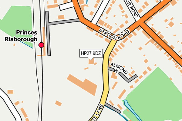
HP27 9DZ is located in the The Risboroughs electoral ward, within the unitary authority of Buckinghamshire and the English Parliamentary constituency of Buckingham. The Sub Integrated Care Board (ICB) Location is NHS Buckinghamshire, Oxfordshire and Berkshire West ICB - 14Y and the police force is Thames Valley. This postcode has been in use since August 1992.


GetTheData
Source: OS OpenMap – Local (Ordnance Survey)
Source: OS VectorMap District (Ordnance Survey)
Licence: Open Government Licence (requires attribution)
| Easting | 480116 |
| Northing | 202708 |
| Latitude | 51.717387 |
| Longitude | -0.841693 |
GetTheData
Source: Open Postcode Geo
Licence: Open Government Licence
| Country | England |
| Postcode District | HP27 |
| ➜ HP27 open data dashboard ➜ See where HP27 is on a map ➜ Where is Princes Risborough? | |
GetTheData
Source: Land Registry Price Paid Data
Licence: Open Government Licence
Elevation or altitude of HP27 9DZ as distance above sea level:
| Metres | Feet | |
|---|---|---|
| Elevation | 110m | 361ft |
Elevation is measured from the approximate centre of the postcode, to the nearest point on an OS contour line from OS Terrain 50, which has contour spacing of ten vertical metres.
➜ How high above sea level am I? Find the elevation of your current position using your device's GPS.
GetTheData
Source: Open Postcode Elevation
Licence: Open Government Licence
| Ward | The Risboroughs |
| Constituency | Buckingham |
GetTheData
Source: ONS Postcode Database
Licence: Open Government Licence
| June 2022 | Violence and sexual offences | On or near Station Road | 246m |
| June 2022 | Anti-social behaviour | On or near Parkfield Rise | 434m |
| June 2022 | Other theft | On or near Windmill Hill | 456m |
| ➜ Get more crime data in our Crime section | |||
GetTheData
Source: data.police.uk
Licence: Open Government Licence
| Picts Lane North (Picts Lane) | Princes Risborough | 53m |
| Picts Lane North (Picts Lane) | Princes Risborough | 65m |
| Railway Station (Station Road) | Princes Risborough | 157m |
| Summerleys Road | Princes Risborough | 273m |
| Summerleys Road | Princes Risborough | 276m |
| Princes Risborough Station | 0.2km |
| Monks Risborough Station | 2.2km |
| Little Kimble Station | 4.5km |
GetTheData
Source: NaPTAN
Licence: Open Government Licence
GetTheData
Source: ONS Postcode Database
Licence: Open Government Licence


➜ Get more ratings from the Food Standards Agency
GetTheData
Source: Food Standards Agency
Licence: FSA terms & conditions
| Last Collection | |||
|---|---|---|---|
| Location | Mon-Fri | Sat | Distance |
| Summerleys Road | 16:30 | 11:45 | 193m |
| Parkfield | 16:30 | 11:45 | 333m |
| Wycombe Road | 16:45 | 11:45 | 366m |
GetTheData
Source: Dracos
Licence: Creative Commons Attribution-ShareAlike
| Facility | Distance |
|---|---|
| Windsor Playing Fields - Princes Risborough Cricket Club Horsenden Lane, Princes Risborough Grass Pitches | 295m |
| Windsor Playing Fields - Risborough Rangers Football Club Horsenden Lane, Princes Risborough Outdoor Tennis Courts, Grass Pitches | 345m |
| Earle Mitchell Recreation Ground Upper Icknield Way, Princes Risborough Grass Pitches | 618m |
GetTheData
Source: Active Places
Licence: Open Government Licence
| School | Phase of Education | Distance |
|---|---|---|
| Princes Risborough School Merton Road, Princes Risborough, HP27 0DR | Secondary | 937m |
| Princes Risborough Primary School Wellington Avenue, Princes Risborough, HP27 9HY | Primary | 1.5km |
| Monks Risborough CofE Primary School Peters Lane, Princes Risborough, HP27 9LZ | Primary | 2.2km |
GetTheData
Source: Edubase
Licence: Open Government Licence
| Risk of HP27 9DZ flooding from rivers and sea | Medium |
| ➜ HP27 9DZ flood map | |
GetTheData
Source: Open Flood Risk by Postcode
Licence: Open Government Licence
The below table lists the International Territorial Level (ITL) codes (formerly Nomenclature of Territorial Units for Statistics (NUTS) codes) and Local Administrative Units (LAU) codes for HP27 9DZ:
| ITL 1 Code | Name |
|---|---|
| TLJ | South East (England) |
| ITL 2 Code | Name |
| TLJ1 | Berkshire, Buckinghamshire and Oxfordshire |
| ITL 3 Code | Name |
| TLJ13 | Buckinghamshire |
| LAU 1 Code | Name |
| E06000060 | Buckinghamshire |
GetTheData
Source: ONS Postcode Directory
Licence: Open Government Licence
The below table lists the Census Output Area (OA), Lower Layer Super Output Area (LSOA), and Middle Layer Super Output Area (MSOA) for HP27 9DZ:
| Code | Name | |
|---|---|---|
| OA | E00090449 | |
| LSOA | E01017930 | Wycombe 001B |
| MSOA | E02003696 | Wycombe 001 |
GetTheData
Source: ONS Postcode Directory
Licence: Open Government Licence
| HP27 9DN | Station Road | 99m |
| HP27 9BP | Station Road | 129m |
| HP27 9DL | Station Road | 137m |
| HP27 9DX | Picts Lane | 142m |
| HP27 9ED | Mill Stream Close | 151m |
| HP27 9EB | Almond Way | 163m |
| HP27 9AU | Manor Park Avenue | 213m |
| HP27 9DB | Poppy Road | 214m |
| HP27 9DD | Milton Gardens | 219m |
| HP27 9DJ | Manor Road | 255m |
GetTheData
Source: Open Postcode Geo; Land Registry Price Paid Data
Licence: Open Government Licence