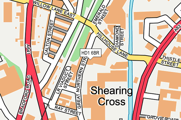
HD1 6BR is located in the Dalton electoral ward, within the metropolitan district of Kirklees and the English Parliamentary constituency of Huddersfield. The Sub Integrated Care Board (ICB) Location is NHS West Yorkshire ICB - X2C4Y and the police force is West Yorkshire. This postcode has been in use since January 1980.


GetTheData
Source: OS OpenMap – Local (Ordnance Survey)
Source: OS VectorMap District (Ordnance Survey)
Licence: Open Government Licence (requires attribution)
| Easting | 414698 |
| Northing | 417582 |
| Latitude | 53.654531 |
| Longitude | -1.779092 |
GetTheData
Source: Open Postcode Geo
Licence: Open Government Licence
| Country | England |
| Postcode District | HD1 |
| ➜ HD1 open data dashboard ➜ See where HD1 is on a map ➜ Where is Huddersfield? | |
GetTheData
Source: Land Registry Price Paid Data
Licence: Open Government Licence
Elevation or altitude of HD1 6BR as distance above sea level:
| Metres | Feet | |
|---|---|---|
| Elevation | 70m | 230ft |
Elevation is measured from the approximate centre of the postcode, to the nearest point on an OS contour line from OS Terrain 50, which has contour spacing of ten vertical metres.
➜ How high above sea level am I? Find the elevation of your current position using your device's GPS.
GetTheData
Source: Open Postcode Elevation
Licence: Open Government Licence
| Ward | Dalton |
| Constituency | Huddersfield |
GetTheData
Source: ONS Postcode Database
Licence: Open Government Licence
| October 2023 | Robbery | On or near Petrol Station | 176m |
| September 2023 | Public order | On or near Petrol Station | 176m |
| September 2023 | Violence and sexual offences | On or near Petrol Station | 176m |
| ➜ Get more crime data in our Crime section | |||
GetTheData
Source: data.police.uk
Licence: Open Government Licence
| Northgate Alder Street (Leeds Road) | Huddersfield Town Centre | 190m |
| Oxford St Bradford Road (Oxford Street) | Huddersfield Town Centre | 220m |
| Leeds Rd Thistle Street (Leeds Road) | Bradley Mills | 254m |
| Leeds Rd Hill House Lane (Leeds Road) | Bradley Mills | 264m |
| Bradford Road Whitehouse Lane (Bradford Road) | Fartown | 304m |
| Huddersfield Station | 0.8km |
| Deighton Station | 2.4km |
| Lockwood Station | 2.6km |
GetTheData
Source: NaPTAN
Licence: Open Government Licence
GetTheData
Source: ONS Postcode Database
Licence: Open Government Licence


➜ Get more ratings from the Food Standards Agency
GetTheData
Source: Food Standards Agency
Licence: FSA terms & conditions
| Last Collection | |||
|---|---|---|---|
| Location | Mon-Fri | Sat | Distance |
| 1 Moorfield Road | 18:30 | 11:45 | 69m |
| Hillhouse | 18:30 | 11:45 | 445m |
| 313-315 Leeds Road | 18:30 | 11:45 | 445m |
GetTheData
Source: Dracos
Licence: Creative Commons Attribution-ShareAlike
| Facility | Distance |
|---|---|
| The Gym Group (Huddersfield) Beck Road, Huddersfield Health and Fitness Gym | 413m |
| The Zone St. Andrews Road, Huddersfield Artificial Grass Pitch | 488m |
| Huddersfield Sports Centre (Closed) Southgate, Huddersfield Sports Hall, Indoor Bowls, Swimming Pool, Health and Fitness Gym, Squash Courts, Studio | 606m |
GetTheData
Source: Active Places
Licence: Open Government Licence
| School | Phase of Education | Distance |
|---|---|---|
| Birkby Junior School Mead Street, Fartown, Huddersfield, HD1 6HE | Primary | 595m |
| Brambles Primary Academy Cambridge Road, Huddersfield, HD1 5BU | Primary | 883m |
| Birkby Infant and Nursery School Blacker Road, Birkby, Huddersfield, HD1 5HQ | Primary | 895m |
GetTheData
Source: Edubase
Licence: Open Government Licence
| Risk of HD1 6BR flooding from rivers and sea | Medium |
| ➜ HD1 6BR flood map | |
GetTheData
Source: Open Flood Risk by Postcode
Licence: Open Government Licence
The below table lists the International Territorial Level (ITL) codes (formerly Nomenclature of Territorial Units for Statistics (NUTS) codes) and Local Administrative Units (LAU) codes for HD1 6BR:
| ITL 1 Code | Name |
|---|---|
| TLE | Yorkshire and The Humber |
| ITL 2 Code | Name |
| TLE4 | West Yorkshire |
| ITL 3 Code | Name |
| TLE44 | Calderdale and Kirklees |
| LAU 1 Code | Name |
| E08000034 | Kirklees |
GetTheData
Source: ONS Postcode Directory
Licence: Open Government Licence
The below table lists the Census Output Area (OA), Lower Layer Super Output Area (LSOA), and Middle Layer Super Output Area (MSOA) for HD1 6BR:
| Code | Name | |
|---|---|---|
| OA | E00055981 | |
| LSOA | E01011107 | Kirklees 029D |
| MSOA | E02002299 | Kirklees 029 |
GetTheData
Source: ONS Postcode Directory
Licence: Open Government Licence
| HD1 6BT | Hillhouse Lane | 68m |
| HD1 6JH | Mulberry Terrace | 125m |
| HD1 6BZ | Diamond Street | 126m |
| HD1 6JA | Hebble Street | 128m |
| HD1 6JG | Laburnum Terrace | 128m |
| HD1 6JJ | Orange Terrace | 133m |
| HD1 6HZ | Alder Street | 135m |
| HD1 6JL | Rose Terrace | 138m |
| HD1 6JN | Hawthorne Terrace | 148m |
| HD1 6BN | Lower Viaduct Street | 153m |
GetTheData
Source: Open Postcode Geo; Land Registry Price Paid Data
Licence: Open Government Licence