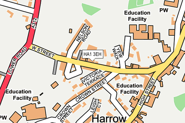
HA1 3EH is located in the Harrow on the Hill electoral ward, within the London borough of Harrow and the English Parliamentary constituency of Harrow West. The Sub Integrated Care Board (ICB) Location is NHS North West London ICB - W2U3Z and the police force is Metropolitan Police. This postcode has been in use since January 1980.


GetTheData
Source: OS OpenMap – Local (Ordnance Survey)
Source: OS VectorMap District (Ordnance Survey)
Licence: Open Government Licence (requires attribution)
| Easting | 515061 |
| Northing | 187264 |
| Latitude | 51.572514 |
| Longitude | -0.341098 |
GetTheData
Source: Open Postcode Geo
Licence: Open Government Licence
| Country | England |
| Postcode District | HA1 |
| ➜ HA1 open data dashboard ➜ See where HA1 is on a map ➜ Where is Harrow? | |
GetTheData
Source: Land Registry Price Paid Data
Licence: Open Government Licence
Elevation or altitude of HA1 3EH as distance above sea level:
| Metres | Feet | |
|---|---|---|
| Elevation | 80m | 262ft |
Elevation is measured from the approximate centre of the postcode, to the nearest point on an OS contour line from OS Terrain 50, which has contour spacing of ten vertical metres.
➜ How high above sea level am I? Find the elevation of your current position using your device's GPS.
GetTheData
Source: Open Postcode Elevation
Licence: Open Government Licence
| Ward | Harrow On The Hill |
| Constituency | Harrow West |
GetTheData
Source: ONS Postcode Database
Licence: Open Government Licence
| November 2023 | Violence and sexual offences | On or near Brickfields | 382m |
| June 2023 | Public order | On or near Brickfields | 382m |
| June 2023 | Violence and sexual offences | On or near Brickfields | 382m |
| ➜ Get more crime data in our Crime section | |||
GetTheData
Source: data.police.uk
Licence: Open Government Licence
| West Street Whitmore Road | Harrow On The Hill | 207m |
| West Street Whitmore Road | Harrow On The Hill | 235m |
| Harrow School (Harrow High Street) | Harrow On The Hill | 245m |
| Harrow School (Harrow High Street) | Harrow On The Hill | 290m |
| Harrow Park (London Road) | Harrow On The Hill | 325m |
| Harrow-on-the-hill Underground Station | Harrow | 791m |
| South Harrow Underground Station | South Harrow | 1,158m |
| West Harrow Underground Station | West Harrow | 1,168m |
| Harrow-on-the-Hill Station | 0.8km |
| Sudbury Hill Harrow Station | 1.6km |
| Kenton Station | 2km |
GetTheData
Source: NaPTAN
Licence: Open Government Licence
GetTheData
Source: ONS Postcode Database
Licence: Open Government Licence


➜ Get more ratings from the Food Standards Agency
GetTheData
Source: Food Standards Agency
Licence: FSA terms & conditions
| Last Collection | |||
|---|---|---|---|
| Location | Mon-Fri | Sat | Distance |
| Victoria Terrace | 17:45 | 12:15 | 40m |
| The Hill Post Office | 17:00 | 12:00 | 208m |
| High Street | 17:45 | 12:00 | 263m |
GetTheData
Source: Dracos
Licence: Creative Commons Attribution-ShareAlike
| Facility | Distance |
|---|---|
| Harrow School (Bessbourough Ground) West Street, Harrow Grass Pitches | 125m |
| John Lyon School Middle Road, Harrow Sports Hall, Swimming Pool, Health and Fitness Gym, Grass Pitches, Artificial Grass Pitch | 254m |
| Harrow School (Philathletic Ground) Whitmore Road, Harrow Grass Pitches | 504m |
GetTheData
Source: Active Places
Licence: Open Government Licence
| School | Phase of Education | Distance |
|---|---|---|
| The John Lyon School Middle Road, Harrow-on-the-Hill, HA2 0HN | Not applicable | 233m |
| Harrow School 5 High Street, Harrow-on-the-Hill, HA1 3HP | Not applicable | 259m |
| St Anselm's Catholic Primary School Roxborough Park, Harrow, HA1 3BE | Primary | 356m |
GetTheData
Source: Edubase
Licence: Open Government Licence
The below table lists the International Territorial Level (ITL) codes (formerly Nomenclature of Territorial Units for Statistics (NUTS) codes) and Local Administrative Units (LAU) codes for HA1 3EH:
| ITL 1 Code | Name |
|---|---|
| TLI | London |
| ITL 2 Code | Name |
| TLI7 | Outer London - West and North West |
| ITL 3 Code | Name |
| TLI74 | Harrow and Hillingdon |
| LAU 1 Code | Name |
| E09000015 | Harrow |
GetTheData
Source: ONS Postcode Directory
Licence: Open Government Licence
The below table lists the Census Output Area (OA), Lower Layer Super Output Area (LSOA), and Middle Layer Super Output Area (MSOA) for HA1 3EH:
| Code | Name | |
|---|---|---|
| OA | E00010694 | |
| LSOA | E01002137 | Harrow 029D |
| MSOA | E02000461 | Harrow 029 |
GetTheData
Source: ONS Postcode Directory
Licence: Open Government Licence
| HA1 3EN | West Street | 27m |
| HA1 3EL | West Street | 28m |
| HA1 3EW | Victoria Terrace | 57m |
| HA2 0HR | Crown Street | 80m |
| HA2 0HT | Crown Street | 81m |
| HA1 3EP | Wellington Terrace | 84m |
| HA1 3ER | West Street | 87m |
| HA1 3ES | West Street | 94m |
| HA1 3ET | Nelson Road | 97m |
| HA1 3EJ | Yew Walk | 103m |
GetTheData
Source: Open Postcode Geo; Land Registry Price Paid Data
Licence: Open Government Licence