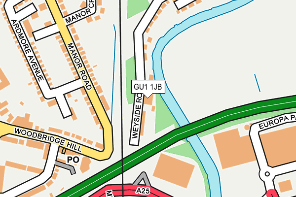
GU1 1JB is located in the Bellfields & Slyfield electoral ward, within the local authority district of Guildford and the English Parliamentary constituency of Guildford. The Sub Integrated Care Board (ICB) Location is NHS Surrey Heartlands ICB - 92A and the police force is Surrey. This postcode has been in use since January 1980.


GetTheData
Source: OS OpenMap – Local (Ordnance Survey)
Source: OS VectorMap District (Ordnance Survey)
Licence: Open Government Licence (requires attribution)
| Easting | 498963 |
| Northing | 151013 |
| Latitude | 51.249711 |
| Longitude | -0.583429 |
GetTheData
Source: Open Postcode Geo
Licence: Open Government Licence
| Country | England |
| Postcode District | GU1 |
| ➜ GU1 open data dashboard ➜ See where GU1 is on a map ➜ Where is Guildford? | |
GetTheData
Source: Land Registry Price Paid Data
Licence: Open Government Licence
Elevation or altitude of GU1 1JB as distance above sea level:
| Metres | Feet | |
|---|---|---|
| Elevation | 30m | 98ft |
Elevation is measured from the approximate centre of the postcode, to the nearest point on an OS contour line from OS Terrain 50, which has contour spacing of ten vertical metres.
➜ How high above sea level am I? Find the elevation of your current position using your device's GPS.
GetTheData
Source: Open Postcode Elevation
Licence: Open Government Licence
| Ward | Bellfields & Slyfield |
| Constituency | Guildford |
GetTheData
Source: ONS Postcode Database
Licence: Open Government Licence
| January 2024 | Shoplifting | On or near Supermarket | 265m |
| January 2024 | Shoplifting | On or near Supermarket | 265m |
| January 2024 | Criminal damage and arson | On or near Berberis Close | 468m |
| ➜ Get more crime data in our Crime section | |||
GetTheData
Source: data.police.uk
Licence: Open Government Licence
| Woodbridge Meadows (Woodbridge Road) | Guildford | 182m |
| Woodbridge Meadows (Woodbridge Road) | Guildford | 205m |
| Weston Road (Woodbridge Hill) | Woodbridge Hill | 226m |
| Weston Road (Woodbridge Hill) | Woodbridge Hill | 263m |
| Ardmore Avenue (Manor Road) | Stoughton | 296m |
| Guildford Station | 1.4km |
| London Road (Guildford) Station | 1.6km |
| Shalford (Surrey) Station | 4.1km |
GetTheData
Source: NaPTAN
Licence: Open Government Licence
GetTheData
Source: ONS Postcode Database
Licence: Open Government Licence


➜ Get more ratings from the Food Standards Agency
GetTheData
Source: Food Standards Agency
Licence: FSA terms & conditions
| Last Collection | |||
|---|---|---|---|
| Location | Mon-Fri | Sat | Distance |
| Woodbridge Hill Post Office | 17:30 | 12:15 | 189m |
| Manor Road | 17:30 | 12:15 | 294m |
| Stoughton Road | 17:15 | 12:00 | 394m |
GetTheData
Source: Dracos
Licence: Creative Commons Attribution-ShareAlike
| Facility | Distance |
|---|---|
| The Gym Group (Guildford) Woodbridge Meadows, Guildford Health and Fitness Gym, Studio | 260m |
| Guildford Waterside Centre Riverside, Guildford Sports Hall, Health and Fitness Gym | 657m |
| Stoughton Recreation Ground Worplesdon Road, Guildford Grass Pitches | 730m |
GetTheData
Source: Active Places
Licence: Open Government Licence
| School | Phase of Education | Distance |
|---|---|---|
| The Hope Service Worplesdon Road, Guildford, GU2 9RS | Not applicable | 576m |
| Christ's College, Guildford Larch Avenue, Guildford, GU1 1JY | Secondary | 674m |
| Stoughton Infant School Stoughton Road, Guildford, GU2 9ZT | Primary | 735m |
GetTheData
Source: Edubase
Licence: Open Government Licence
| Risk of GU1 1JB flooding from rivers and sea | High |
| ➜ GU1 1JB flood map | |
GetTheData
Source: Open Flood Risk by Postcode
Licence: Open Government Licence
The below table lists the International Territorial Level (ITL) codes (formerly Nomenclature of Territorial Units for Statistics (NUTS) codes) and Local Administrative Units (LAU) codes for GU1 1JB:
| ITL 1 Code | Name |
|---|---|
| TLJ | South East (England) |
| ITL 2 Code | Name |
| TLJ2 | Surrey, East and West Sussex |
| ITL 3 Code | Name |
| TLJ25 | West Surrey |
| LAU 1 Code | Name |
| E07000209 | Guildford |
GetTheData
Source: ONS Postcode Directory
Licence: Open Government Licence
The below table lists the Census Output Area (OA), Lower Layer Super Output Area (LSOA), and Middle Layer Super Output Area (MSOA) for GU1 1JB:
| Code | Name | |
|---|---|---|
| OA | E00155483 | |
| LSOA | E01030484 | Guildford 007D |
| MSOA | E02006350 | Guildford 007 |
GetTheData
Source: ONS Postcode Directory
Licence: Open Government Licence
| GU1 1HX | Weyside Road | 86m |
| GU2 9NE | Manor Road | 132m |
| GU2 9ZZ | Heather Close | 158m |
| GU2 9AA | Woodbridge Hill | 194m |
| GU1 1JD | Weyside Gardens | 206m |
| GU2 9AB | Woodbridge Hill | 210m |
| GU2 9NF | Manor Crescent | 247m |
| GU2 9NJ | Ardmore Avenue | 254m |
| GU2 9AD | Woodbridge Hill | 259m |
| GU1 1HN | Weyview Close | 259m |
GetTheData
Source: Open Postcode Geo; Land Registry Price Paid Data
Licence: Open Government Licence