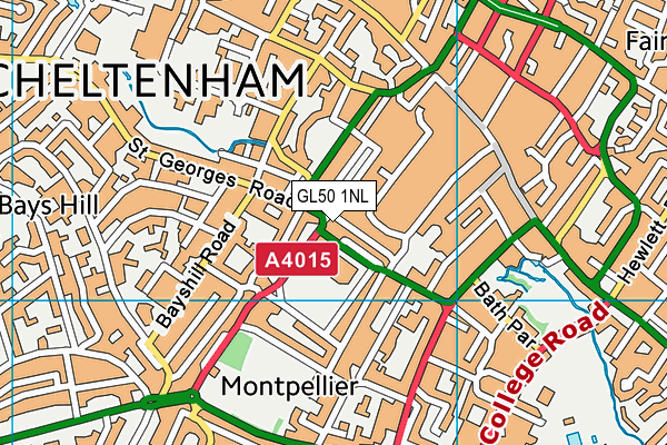
GL50 1NL lies on Promenade in Cheltenham. GL50 1NL is located in the College electoral ward, within the local authority district of Cheltenham and the English Parliamentary constituency of Cheltenham. The Sub Integrated Care Board (ICB) Location is NHS Gloucestershire ICB - 11M and the police force is Gloucestershire. This postcode has been in use since January 1980.


GetTheData
Source: OS OpenMap – Local (Ordnance Survey)
Source: OS VectorMap District (Ordnance Survey)
Licence: Open Government Licence (requires attribution)
| Easting | 394724 |
| Northing | 222172 |
| Latitude | 51.898068 |
| Longitude | -2.078083 |
GetTheData
Source: Open Postcode Geo
Licence: Open Government Licence
| Street | Promenade |
| Town/City | Cheltenham |
| Country | England |
| Postcode District | GL50 |
| ➜ GL50 open data dashboard ➜ See where GL50 is on a map ➜ Where is Cheltenham? | |
GetTheData
Source: Land Registry Price Paid Data
Licence: Open Government Licence
Elevation or altitude of GL50 1NL as distance above sea level:
| Metres | Feet | |
|---|---|---|
| Elevation | 60m | 197ft |
Elevation is measured from the approximate centre of the postcode, to the nearest point on an OS contour line from OS Terrain 50, which has contour spacing of ten vertical metres.
➜ How high above sea level am I? Find the elevation of your current position using your device's GPS.
GetTheData
Source: Open Postcode Elevation
Licence: Open Government Licence
| Ward | College |
| Constituency | Cheltenham |
GetTheData
Source: ONS Postcode Database
Licence: Open Government Licence
| January 2024 | Burglary | On or near Parking Area | 301m |
| December 2023 | Violence and sexual offences | On or near Parking Area | 301m |
| December 2023 | Violence and sexual offences | On or near Jenner Walk | 455m |
| ➜ Get more crime data in our Crime section | |||
GetTheData
Source: data.police.uk
Licence: Open Government Licence
| Promenade | Cheltenham | 31m |
| Promenade | Cheltenham | 45m |
| Imperial Square School Stop (Promenade) | Cheltenham | 61m |
| Promenade | Cheltenham | 71m |
| Promenade | Cheltenham | 93m |
| Cheltenham Spa Station | 1.5km |
GetTheData
Source: NaPTAN
Licence: Open Government Licence
GetTheData
Source: ONS Postcode Database
Licence: Open Government Licence


➜ Get more ratings from the Food Standards Agency
GetTheData
Source: Food Standards Agency
Licence: FSA terms & conditions
| Last Collection | |||
|---|---|---|---|
| Location | Mon-Fri | Sat | Distance |
| Oriel Road | 17:40 | 13:00 | 193m |
| Promenade (Double) | 18:30 | 13:00 | 218m |
| Bayshill Road | 17:30 | 13:00 | 251m |
GetTheData
Source: Dracos
Licence: Creative Commons Attribution-ShareAlike
| Facility | Distance |
|---|---|
| Reset (Closed) St. Georges Road, Cheltenham Health and Fitness Gym | 138m |
| Reset Gym & Therapy Rooms Oriel Road, Cheltenham Health and Fitness Gym, Studio | 274m |
| Ymca (Cheltenham Vittoria Walk) Vittoria Walk, Cheltenham Sports Hall, Squash Courts, Studio | 285m |
GetTheData
Source: Active Places
Licence: Open Government Licence
| School | Phase of Education | Distance |
|---|---|---|
| Cheltenham Ladies' College Bayshill Road, Cheltenham, GL50 3EP | Not applicable | 183m |
| Gloucestershire Hospital Education Service St George's Road, County Offices, Cheltenham, GL50 3EW | Not applicable | 386m |
| The Catholic School of Saint Gregory the Great St James Square, Cheltenham, GL50 3QG | Primary | 547m |
GetTheData
Source: Edubase
Licence: Open Government Licence
| Risk of GL50 1NL flooding from rivers and sea | Medium |
| ➜ GL50 1NL flood map | |
GetTheData
Source: Open Flood Risk by Postcode
Licence: Open Government Licence
The below table lists the International Territorial Level (ITL) codes (formerly Nomenclature of Territorial Units for Statistics (NUTS) codes) and Local Administrative Units (LAU) codes for GL50 1NL:
| ITL 1 Code | Name |
|---|---|
| TLK | South West (England) |
| ITL 2 Code | Name |
| TLK1 | Gloucestershire, Wiltshire and Bath/Bristol area |
| ITL 3 Code | Name |
| TLK13 | Gloucestershire CC |
| LAU 1 Code | Name |
| E07000078 | Cheltenham |
GetTheData
Source: ONS Postcode Directory
Licence: Open Government Licence
The below table lists the Census Output Area (OA), Lower Layer Super Output Area (LSOA), and Middle Layer Super Output Area (MSOA) for GL50 1NL:
| Code | Name | |
|---|---|---|
| OA | E00112397 | |
| LSOA | E01022117 | Cheltenham 009B |
| MSOA | E02004608 | Cheltenham 009 |
GetTheData
Source: ONS Postcode Directory
Licence: Open Government Licence
| GL50 1PT | Imperial Lane | 30m |
| GL50 1PZ | The Quadrangle | 71m |
| GL50 1PQ | Imperial Lane | 71m |
| GL50 1NB | Promenade | 91m |
| GL50 1QB | Imperial Square | 92m |
| GL50 1NW | Promenade | 99m |
| GL50 1PR | Imperial Lane | 104m |
| GL50 1HR | Ormond Terrace | 112m |
| GL50 1PJ | Promenade | 124m |
| GL50 1HT | Rodney Road | 133m |
GetTheData
Source: Open Postcode Geo; Land Registry Price Paid Data
Licence: Open Government Licence