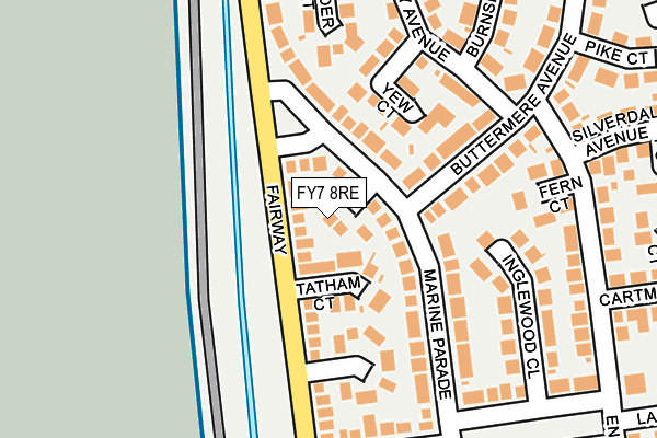
FY7 8RE lies on Brant Court in Fleetwood. FY7 8RE is located in the Rossall electoral ward, within the local authority district of Wyre and the English Parliamentary constituency of Lancaster and Fleetwood. The Sub Integrated Care Board (ICB) Location is NHS Lancashire and South Cumbria ICB - 02M and the police force is Lancashire. This postcode has been in use since January 1980.


GetTheData
Source: OS OpenMap – Local (Ordnance Survey)
Source: OS VectorMap District (Ordnance Survey)
Licence: Open Government Licence (requires attribution)
| Easting | 331207 |
| Northing | 446359 |
| Latitude | 53.908800 |
| Longitude | -3.048666 |
GetTheData
Source: Open Postcode Geo
Licence: Open Government Licence
| Street | Brant Court |
| Town/City | Fleetwood |
| Country | England |
| Postcode District | FY7 |
➜ See where FY7 is on a map ➜ Where is Fleetwood? | |
GetTheData
Source: Land Registry Price Paid Data
Licence: Open Government Licence
Elevation or altitude of FY7 8RE as distance above sea level:
| Metres | Feet | |
|---|---|---|
| Elevation | 10m | 33ft |
Elevation is measured from the approximate centre of the postcode, to the nearest point on an OS contour line from OS Terrain 50, which has contour spacing of ten vertical metres.
➜ How high above sea level am I? Find the elevation of your current position using your device's GPS.
GetTheData
Source: Open Postcode Elevation
Licence: Open Government Licence
| Ward | Rossall |
| Constituency | Lancaster And Fleetwood |
GetTheData
Source: ONS Postcode Database
Licence: Open Government Licence
2021 10 JUN £190,000 |
2000 20 OCT £57,000 |
1, BRANT COURT, FLEETWOOD, FY7 8RE 1998 27 OCT £52,000 |
3, BRANT COURT, FLEETWOOD, FY7 8RE 1998 17 JUL £60,000 |
4, BRANT COURT, FLEETWOOD, FY7 8RE 1995 21 FEB £56,750 |
GetTheData
Source: HM Land Registry Price Paid Data
Licence: Contains HM Land Registry data © Crown copyright and database right 2025. This data is licensed under the Open Government Licence v3.0.
| Marine Parade | Larkholme | 191m |
| Marine Parade | Larkholme | 197m |
| Pike Court (Buttermere Avenue) | Larkholme | 260m |
| Pike Court (Buttermere Avenue) | Larkholme | 269m |
| Marine Park (Marine Parade) | Larkholme | 293m |
| Rossall Square (Blackpool Tramway) (A587 Broadway) | Rossall Beach | 1,204m |
| Broadwater (Blackpool Tramway) (The Crescent) | Broadwater | 1,210m |
| Heathfield Road (Blackpool Tramway) (Heathfield Road) | Broadwater | 1,408m |
| Rossall School (Blackpool Tramway) (A587 Broadway) | Rossall Beach | 1,464m |
GetTheData
Source: NaPTAN
Licence: Open Government Licence
| Percentage of properties with Next Generation Access | 100.0% |
| Percentage of properties with Superfast Broadband | 0.0% |
| Percentage of properties with Ultrafast Broadband | 0.0% |
| Percentage of properties with Full Fibre Broadband | 0.0% |
Superfast Broadband is between 30Mbps and 300Mbps
Ultrafast Broadband is > 300Mbps
| Percentage of properties unable to receive 2Mbps | 0.0% |
| Percentage of properties unable to receive 5Mbps | 0.0% |
| Percentage of properties unable to receive 10Mbps | 0.0% |
| Percentage of properties unable to receive 30Mbps | 100.0% |
GetTheData
Source: Ofcom
Licence: Ofcom Terms of Use (requires attribution)
GetTheData
Source: ONS Postcode Database
Licence: Open Government Licence


➜ Get more ratings from the Food Standards Agency
GetTheData
Source: Food Standards Agency
Licence: FSA terms & conditions
| Last Collection | |||
|---|---|---|---|
| Location | Mon-Fri | Sat | Distance |
| Larkholme Avenue | 16:45 | 11:30 | 388m |
| Chatsworth Post Office | 18:00 | 12:15 | 538m |
| Ullswater Avenue | 16:30 | 12:15 | 645m |
GetTheData
Source: Dracos
Licence: Creative Commons Attribution-ShareAlike
| Risk of FY7 8RE flooding from rivers and sea | Low |
| ➜ FY7 8RE flood map | |
GetTheData
Source: Open Flood Risk by Postcode
Licence: Open Government Licence
The below table lists the International Territorial Level (ITL) codes (formerly Nomenclature of Territorial Units for Statistics (NUTS) codes) and Local Administrative Units (LAU) codes for FY7 8RE:
| ITL 1 Code | Name |
|---|---|
| TLD | North West (England) |
| ITL 2 Code | Name |
| TLD4 | Lancashire |
| ITL 3 Code | Name |
| TLD44 | Lancaster and Wyre |
| LAU 1 Code | Name |
| E07000128 | Wyre |
GetTheData
Source: ONS Postcode Directory
Licence: Open Government Licence
The below table lists the Census Output Area (OA), Lower Layer Super Output Area (LSOA), and Middle Layer Super Output Area (MSOA) for FY7 8RE:
| Code | Name | |
|---|---|---|
| OA | E00129882 | |
| LSOA | E01025591 | Wyre 003B |
| MSOA | E02005321 | Wyre 003 |
GetTheData
Source: ONS Postcode Directory
Licence: Open Government Licence
| FY7 8RF | Tatham Court | 77m |
| FY7 8QT | Marine Parade | 79m |
| FY7 8RB | Marine Parade | 91m |
| FY7 8QJ | Yew Court | 144m |
| FY7 8RG | Wraywood Court | 145m |
| FY7 8PF | Buttermere Avenue | 149m |
| FY7 8PE | Inglewood Close | 178m |
| FY7 8QL | Alder Court | 190m |
| FY7 8RQ | Larkholme Parade | 197m |
| FY7 8QH | Lazenby Avenue | 202m |
GetTheData
Source: Open Postcode Geo; Land Registry Price Paid Data
Licence: Open Government Licence