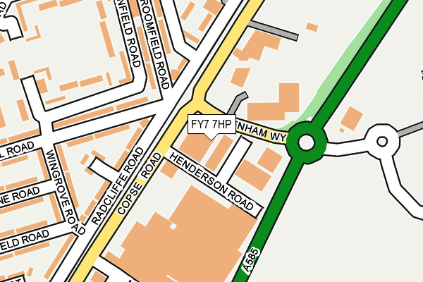
FY7 7HP is located in the Mount electoral ward, within the local authority district of Wyre and the English Parliamentary constituency of Lancaster and Fleetwood. The Sub Integrated Care Board (ICB) Location is NHS Lancashire and South Cumbria ICB - 02M and the police force is Lancashire. This postcode has been in use since June 1996.


GetTheData
Source: OS OpenMap – Local (Ordnance Survey)
Source: OS VectorMap District (Ordnance Survey)
Licence: Open Government Licence (requires attribution)
| Easting | 332886 |
| Northing | 446781 |
| Latitude | 53.912812 |
| Longitude | -3.023205 |
GetTheData
Source: Open Postcode Geo
Licence: Open Government Licence
| Country | England |
| Postcode District | FY7 |
| ➜ FY7 open data dashboard ➜ See where FY7 is on a map ➜ Where is Fleetwood? | |
GetTheData
Source: Land Registry Price Paid Data
Licence: Open Government Licence
Elevation or altitude of FY7 7HP as distance above sea level:
| Metres | Feet | |
|---|---|---|
| Elevation | 10m | 33ft |
Elevation is measured from the approximate centre of the postcode, to the nearest point on an OS contour line from OS Terrain 50, which has contour spacing of ten vertical metres.
➜ How high above sea level am I? Find the elevation of your current position using your device's GPS.
GetTheData
Source: Open Postcode Elevation
Licence: Open Government Licence
| Ward | Mount |
| Constituency | Lancaster And Fleetwood |
GetTheData
Source: ONS Postcode Database
Licence: Open Government Licence
| January 2024 | Violence and sexual offences | On or near Gordon Road | 469m |
| December 2023 | Criminal damage and arson | On or near Gordon Road | 469m |
| December 2023 | Violence and sexual offences | On or near Gordon Road | 469m |
| ➜ Get more crime data in our Crime section | |||
GetTheData
Source: data.police.uk
Licence: Open Government Licence
| Nelson Court (Hatfield Avenue) | Fleetwood | 332m |
| Nelson Court (Hatfield Avenue) | Fleetwood | 334m |
| Highbury Avenue (Hatfield Avenue) | Fleetwood | 339m |
| Highbury Avenue (Hatfield Avenue) | Fleetwood | 350m |
| Oxford Road (Highbury Avenue) | Fleetwood | 373m |
| Lindel Road (Blackpool Tramway) (Lindel Road) | Freeport | 93m |
| Heathfield Road (Blackpool Tramway) (Heathfield Road) | Broadwater | 411m |
| Stanley Road (Blackpool Tramway) (Stanley Road) | Freeport | 451m |
| Fisherman's Walk (Blackpool Tramway) (Ash Street) | Freeport | 855m |
| Broadwater (Blackpool Tramway) (The Crescent) | Broadwater | 1,153m |
GetTheData
Source: NaPTAN
Licence: Open Government Licence
GetTheData
Source: ONS Postcode Database
Licence: Open Government Licence


➜ Get more ratings from the Food Standards Agency
GetTheData
Source: Food Standards Agency
Licence: FSA terms & conditions
| Last Collection | |||
|---|---|---|---|
| Location | Mon-Fri | Sat | Distance |
| Highbury Avenue | 17:15 | 12:45 | 336m |
| Heathfield Road | 16:45 | 12:00 | 459m |
| Radcliffe Road | 17:00 | 12:45 | 628m |
GetTheData
Source: Dracos
Licence: Creative Commons Attribution-ShareAlike
| Facility | Distance |
|---|---|
| Fleetwood Town (Highbury Stadium) Park Avenue, Fleetwood Grass Pitches | 416m |
| Flakefleet Primary School Northfleet Avenue, Fleetwood Grass Pitches | 579m |
| Elite Muscle And Fitness Fleetwood (Closed) Copse Road, Fleetwood Health and Fitness Gym | 610m |
GetTheData
Source: Active Places
Licence: Open Government Licence
| School | Phase of Education | Distance |
|---|---|---|
| Fleetwood Flakefleet Primary School Northfleet Avenue, Fleetwood, FY7 7ND | Primary | 610m |
| Fleetwood High School Broadway, Fleetwood High School, FLEETWOOD, FY7 8HE | Secondary | 793m |
| St Wulstan's and St Edmund's Catholic Academy Poulton Road, Fleetwood, FY7 7JY | Primary | 876m |
GetTheData
Source: Edubase
Licence: Open Government Licence
| Risk of FY7 7HP flooding from rivers and sea | Very Low |
| ➜ FY7 7HP flood map | |
GetTheData
Source: Open Flood Risk by Postcode
Licence: Open Government Licence
The below table lists the International Territorial Level (ITL) codes (formerly Nomenclature of Territorial Units for Statistics (NUTS) codes) and Local Administrative Units (LAU) codes for FY7 7HP:
| ITL 1 Code | Name |
|---|---|
| TLD | North West (England) |
| ITL 2 Code | Name |
| TLD4 | Lancashire |
| ITL 3 Code | Name |
| TLD44 | Lancaster and Wyre |
| LAU 1 Code | Name |
| E07000128 | Wyre |
GetTheData
Source: ONS Postcode Directory
Licence: Open Government Licence
The below table lists the Census Output Area (OA), Lower Layer Super Output Area (LSOA), and Middle Layer Super Output Area (MSOA) for FY7 7HP:
| Code | Name | |
|---|---|---|
| OA | E00129779 | |
| LSOA | E01025575 | Wyre 005B |
| MSOA | E02005323 | Wyre 005 |
GetTheData
Source: ONS Postcode Directory
Licence: Open Government Licence
| FY7 7PA | Harbour Trading Estate | 63m |
| FY7 7NS | Radcliffe Road | 144m |
| FY7 7LU | Lindel Road | 165m |
| FY7 7EZ | Broomfield Road | 173m |
| FY7 7NT | Mayfield Place | 179m |
| FY7 7HA | Broomfield Road | 200m |
| FY7 7NW | Wingrove Road | 208m |
| FY7 6SD | Wyre Street | 271m |
| FY7 7PB | Copse Road | 279m |
| FY7 6SF | Hatfield Avenue | 307m |
GetTheData
Source: Open Postcode Geo; Land Registry Price Paid Data
Licence: Open Government Licence