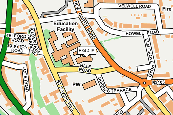
EX4 4JS is located in the St David's electoral ward, within the local authority district of Exeter and the English Parliamentary constituency of Exeter. The Sub Integrated Care Board (ICB) Location is NHS Devon ICB - 15N and the police force is Devon & Cornwall. This postcode has been in use since January 1980.


GetTheData
Source: OS OpenMap – Local (Ordnance Survey)
Source: OS VectorMap District (Ordnance Survey)
Licence: Open Government Licence (requires attribution)
| Easting | 291518 |
| Northing | 93196 |
| Latitude | 50.728223 |
| Longitude | -3.538392 |
GetTheData
Source: Open Postcode Geo
Licence: Open Government Licence
| Country | England |
| Postcode District | EX4 |
| ➜ EX4 open data dashboard ➜ See where EX4 is on a map ➜ Where is Exeter? | |
GetTheData
Source: Land Registry Price Paid Data
Licence: Open Government Licence
Elevation or altitude of EX4 4JS as distance above sea level:
| Metres | Feet | |
|---|---|---|
| Elevation | 40m | 131ft |
Elevation is measured from the approximate centre of the postcode, to the nearest point on an OS contour line from OS Terrain 50, which has contour spacing of ten vertical metres.
➜ How high above sea level am I? Find the elevation of your current position using your device's GPS.
GetTheData
Source: Open Postcode Elevation
Licence: Open Government Licence
| Ward | St David's |
| Constituency | Exeter |
GetTheData
Source: ONS Postcode Database
Licence: Open Government Licence
| October 2022 | Public order | On or near Haldon Road | 354m |
| July 2022 | Violence and sexual offences | On or near Haldon Road | 354m |
| July 2022 | Anti-social behaviour | On or near Haldon Road | 354m |
| ➜ Get more crime data in our Crime section | |||
GetTheData
Source: data.police.uk
Licence: Open Government Licence
| Exeter College (Hele Road) | St Davids | 49m |
| Exeter College (Hele Road) | St Davids | 60m |
| Hele Road | St Davids | 102m |
| Exeter College (New North Road) | St Davids | 103m |
| The Imperial (New North Road) | St Davids | 195m |
| Exeter St Davids Station | 0.4km |
| Exeter Central Station | 0.4km |
| St James Park (Devon) Station | 1.2km |
GetTheData
Source: NaPTAN
Licence: Open Government Licence
GetTheData
Source: ONS Postcode Database
Licence: Open Government Licence


➜ Get more ratings from the Food Standards Agency
GetTheData
Source: Food Standards Agency
Licence: FSA terms & conditions
| Last Collection | |||
|---|---|---|---|
| Location | Mon-Fri | Sat | Distance |
| Clocktower | 19:00 | 12:30 | 230m |
| Velwell Road | 18:30 | 12:00 | 273m |
| St David's Hill Post Office | 19:00 | 12:00 | 312m |
GetTheData
Source: Dracos
Licence: Creative Commons Attribution-ShareAlike
| Facility | Distance |
|---|---|
| Exeter College (Hele Road) (Closed) Hele Road, Exeter Sports Hall | 13m |
| Exeter College (Queen Street) Queen Street, Exeter Sports Hall, Health and Fitness Gym, Studio | 403m |
| Studio One-to-one Fitness (Closed) Lower North Street, Exeter Health and Fitness Gym | 485m |
GetTheData
Source: Active Places
Licence: Open Government Licence
| School | Phase of Education | Distance |
|---|---|---|
| Exeter College Hele Road, Exeter, EX4 4JS | 16 plus | 13m |
| St Wilfrid's School 25-29 St David's Hill, Exeter, EX4 4DA | Not applicable | 299m |
| St David's CofE Primary School Dinham Road, Exeter, EX4 4EE | Primary | 441m |
GetTheData
Source: Edubase
Licence: Open Government Licence
The below table lists the International Territorial Level (ITL) codes (formerly Nomenclature of Territorial Units for Statistics (NUTS) codes) and Local Administrative Units (LAU) codes for EX4 4JS:
| ITL 1 Code | Name |
|---|---|
| TLK | South West (England) |
| ITL 2 Code | Name |
| TLK4 | Devon |
| ITL 3 Code | Name |
| TLK43 | Devon CC |
| LAU 1 Code | Name |
| E07000041 | Exeter |
GetTheData
Source: ONS Postcode Directory
Licence: Open Government Licence
The below table lists the Census Output Area (OA), Lower Layer Super Output Area (LSOA), and Middle Layer Super Output Area (MSOA) for EX4 4JS:
| Code | Name | |
|---|---|---|
| OA | E00171929 | |
| LSOA | E01020017 | Exeter 008D |
| MSOA | E02004156 | Exeter 008 |
GetTheData
Source: ONS Postcode Directory
Licence: Open Government Licence
| EX4 4LH | Howell Road | 103m |
| EX4 4DP | St Davids Hill | 112m |
| EX4 4LF | Linden Vale | 142m |
| EX4 4DW | St Davids Hill | 145m |
| EX4 4HU | Little Silver | 145m |
| EX4 4HR | Queens Terrace | 152m |
| EX4 4DX | St Davids Hill | 153m |
| EX4 4DU | St Davids Hill | 153m |
| EX4 4JJ | Bystock Close | 172m |
| EX4 4HX | Russell Terrace | 175m |
GetTheData
Source: Open Postcode Geo; Land Registry Price Paid Data
Licence: Open Government Licence