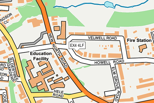
EX4 4LF lies on Linden Vale in Exeter. EX4 4LF is located in the Duryard and St James electoral ward, within the local authority district of Exeter and the English Parliamentary constituency of Exeter. The Sub Integrated Care Board (ICB) Location is NHS Devon ICB - 15N and the police force is Devon & Cornwall. This postcode has been in use since January 1980.


GetTheData
Source: OS OpenMap – Local (Ordnance Survey)
Source: OS VectorMap District (Ordnance Survey)
Licence: Open Government Licence (requires attribution)
| Easting | 291590 |
| Northing | 93318 |
| Latitude | 50.729322 |
| Longitude | -3.537422 |
GetTheData
Source: Open Postcode Geo
Licence: Open Government Licence
| Street | Linden Vale |
| Town/City | Exeter |
| Country | England |
| Postcode District | EX4 |
➜ See where EX4 is on a map ➜ Where is Exeter? | |
GetTheData
Source: Land Registry Price Paid Data
Licence: Open Government Licence
Elevation or altitude of EX4 4LF as distance above sea level:
| Metres | Feet | |
|---|---|---|
| Elevation | 40m | 131ft |
Elevation is measured from the approximate centre of the postcode, to the nearest point on an OS contour line from OS Terrain 50, which has contour spacing of ten vertical metres.
➜ How high above sea level am I? Find the elevation of your current position using your device's GPS.
GetTheData
Source: Open Postcode Elevation
Licence: Open Government Licence
| Ward | Duryard And St James |
| Constituency | Exeter |
GetTheData
Source: ONS Postcode Database
Licence: Open Government Licence
| The Imperial (New North Road) | St Davids | 134m |
| Exeter College (New North Road) | St Davids | 151m |
| The Imperial (New North Road) | St Davids | 164m |
| Exeter College (Hele Road) | St Davids | 177m |
| Exeter College (Hele Road) | St Davids | 182m |
| Exeter St Davids Station | 0.4km |
| Exeter Central Station | 0.4km |
| St James Park (Devon) Station | 1.1km |
GetTheData
Source: NaPTAN
Licence: Open Government Licence
| Percentage of properties with Next Generation Access | 100.0% |
| Percentage of properties with Superfast Broadband | 100.0% |
| Percentage of properties with Ultrafast Broadband | 100.0% |
| Percentage of properties with Full Fibre Broadband | 100.0% |
Superfast Broadband is between 30Mbps and 300Mbps
Ultrafast Broadband is > 300Mbps
| Percentage of properties unable to receive 2Mbps | 0.0% |
| Percentage of properties unable to receive 5Mbps | 0.0% |
| Percentage of properties unable to receive 10Mbps | 0.0% |
| Percentage of properties unable to receive 30Mbps | 0.0% |
GetTheData
Source: Ofcom
Licence: Ofcom Terms of Use (requires attribution)
Estimated total energy consumption in EX4 4LF by fuel type, 2015.
| Consumption (kWh) | 72,833 |
|---|---|
| Meter count | 6 |
| Mean (kWh/meter) | 12,139 |
| Median (kWh/meter) | 13,160 |
| Consumption (kWh) | 20,505 |
|---|---|
| Meter count | 6 |
| Mean (kWh/meter) | 3,417 |
| Median (kWh/meter) | 3,289 |
GetTheData
Source: Postcode level gas estimates: 2015 (experimental)
Source: Postcode level electricity estimates: 2015 (experimental)
Licence: Open Government Licence
GetTheData
Source: ONS Postcode Database
Licence: Open Government Licence


➜ Get more ratings from the Food Standards Agency
GetTheData
Source: Food Standards Agency
Licence: FSA terms & conditions
| Last Collection | |||
|---|---|---|---|
| Location | Mon-Fri | Sat | Distance |
| Velwell Road | 18:30 | 12:00 | 185m |
| Clocktower | 19:00 | 12:30 | 271m |
| Streatham | 19:00 | 12:30 | 289m |
GetTheData
Source: Dracos
Licence: Creative Commons Attribution-ShareAlike
The below table lists the International Territorial Level (ITL) codes (formerly Nomenclature of Territorial Units for Statistics (NUTS) codes) and Local Administrative Units (LAU) codes for EX4 4LF:
| ITL 1 Code | Name |
|---|---|
| TLK | South West (England) |
| ITL 2 Code | Name |
| TLK4 | Devon |
| ITL 3 Code | Name |
| TLK43 | Devon CC |
| LAU 1 Code | Name |
| E07000041 | Exeter |
GetTheData
Source: ONS Postcode Directory
Licence: Open Government Licence
The below table lists the Census Output Area (OA), Lower Layer Super Output Area (LSOA), and Middle Layer Super Output Area (MSOA) for EX4 4LF:
| Code | Name | |
|---|---|---|
| OA | E00101333 | |
| LSOA | E01020021 | Exeter 004D |
| MSOA | E02004152 | Exeter 004 |
GetTheData
Source: ONS Postcode Directory
Licence: Open Government Licence
| EX4 4LH | Howell Road | 39m |
| EX4 4LG | Howell Road | 94m |
| EX4 4LD | Velwell Road | 98m |
| EX4 4LA | New North Road | 147m |
| EX4 4LE | Velwell Road | 192m |
| EX4 4AJ | New North Road | 198m |
| EX4 4LJ | Woodbine Terrace | 204m |
| EX4 4LL | Elm Grove Road | 208m |
| EX4 4HH | New North Road | 211m |
| EX4 4HR | Queens Terrace | 226m |
GetTheData
Source: Open Postcode Geo; Land Registry Price Paid Data
Licence: Open Government Licence