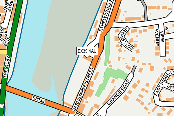
EX39 4AU is located in the Bideford East electoral ward, within the local authority district of Torridge and the English Parliamentary constituency of Torridge and West Devon. The Sub Integrated Care Board (ICB) Location is NHS Devon ICB - 15N and the police force is Devon & Cornwall. This postcode has been in use since April 1987.


GetTheData
Source: OS OpenMap – Local (Ordnance Survey)
Source: OS VectorMap District (Ordnance Survey)
Licence: Open Government Licence (requires attribution)
| Easting | 245734 |
| Northing | 126571 |
| Latitude | 51.017765 |
| Longitude | -4.200736 |
GetTheData
Source: Open Postcode Geo
Licence: Open Government Licence
| Country | England |
| Postcode District | EX39 |
| ➜ EX39 open data dashboard ➜ See where EX39 is on a map ➜ Where is Bideford? | |
GetTheData
Source: Land Registry Price Paid Data
Licence: Open Government Licence
Elevation or altitude of EX39 4AU as distance above sea level:
| Metres | Feet | |
|---|---|---|
| Elevation | 10m | 33ft |
Elevation is measured from the approximate centre of the postcode, to the nearest point on an OS contour line from OS Terrain 50, which has contour spacing of ten vertical metres.
➜ How high above sea level am I? Find the elevation of your current position using your device's GPS.
GetTheData
Source: Open Postcode Elevation
Licence: Open Government Licence
| Ward | Bideford East |
| Constituency | Torridge And West Devon |
GetTheData
Source: ONS Postcode Database
Licence: Open Government Licence
| October 2022 | Criminal damage and arson | On or near Chudleigh Road | 240m |
| October 2022 | Drugs | On or near Boards Court | 420m |
| July 2022 | Possession of weapons | On or near The Quay | 273m |
| ➜ Get more crime data in our Crime section | |||
GetTheData
Source: data.police.uk
Licence: Open Government Licence
| Ship On Launch (Barnstaple Street) | Bideford | 72m |
| Ship On Launch (Barnstaple Street) | Bideford | 78m |
| Salterns Terrace | Bideford | 156m |
| Royal Hotel | Bideford | 192m |
| Royal Hotel | Bideford | 196m |
GetTheData
Source: NaPTAN
Licence: Open Government Licence
GetTheData
Source: ONS Postcode Database
Licence: Open Government Licence


➜ Get more ratings from the Food Standards Agency
GetTheData
Source: Food Standards Agency
Licence: FSA terms & conditions
| Last Collection | |||
|---|---|---|---|
| Location | Mon-Fri | Sat | Distance |
| Bideford Delivery Office | 18:30 | 13:00 | 355m |
| East-the-water | 18:00 | 12:00 | 360m |
| Market Place | 18:15 | 12:30 | 458m |
GetTheData
Source: Dracos
Licence: Creative Commons Attribution-ShareAlike
| Facility | Distance |
|---|---|
| Bideford Youth Centre Kingsley Road, Bideford Sports Hall | 417m |
| Fitness M8 Ltd (Closed) Mill Street, Bideford Health and Fitness Gym, Studio | 444m |
| Victoria Park (Bideford) Kingsley Road, Bideford Grass Pitches | 608m |
GetTheData
Source: Active Places
Licence: Open Government Licence
| School | Phase of Education | Distance |
|---|---|---|
| East-the-Water Community Primary School Mines Road, Bideford, EX39 4BZ | Primary | 779m |
| St Mary's Church of England Primary School Chanters Road, Bideford, EX39 2QN | Primary | 928m |
| West Croft School Coronation Road, Bideford, EX39 3DE | Primary | 992m |
GetTheData
Source: Edubase
Licence: Open Government Licence
| Risk of EX39 4AU flooding from rivers and sea | Medium |
| ➜ EX39 4AU flood map | |
GetTheData
Source: Open Flood Risk by Postcode
Licence: Open Government Licence
The below table lists the International Territorial Level (ITL) codes (formerly Nomenclature of Territorial Units for Statistics (NUTS) codes) and Local Administrative Units (LAU) codes for EX39 4AU:
| ITL 1 Code | Name |
|---|---|
| TLK | South West (England) |
| ITL 2 Code | Name |
| TLK4 | Devon |
| ITL 3 Code | Name |
| TLK43 | Devon CC |
| LAU 1 Code | Name |
| E07000046 | Torridge |
GetTheData
Source: ONS Postcode Directory
Licence: Open Government Licence
The below table lists the Census Output Area (OA), Lower Layer Super Output Area (LSOA), and Middle Layer Super Output Area (MSOA) for EX39 4AU:
| Code | Name | |
|---|---|---|
| OA | E00102711 | |
| LSOA | E01020277 | Torridge 004A |
| MSOA | E02004223 | Torridge 004 |
GetTheData
Source: ONS Postcode Directory
Licence: Open Government Licence
| EX39 4AE | Barnstaple Street | 82m |
| EX39 4AF | Vinegar Hill | 84m |
| EX39 4AW | Grange Bungalows | 151m |
| EX39 4AP | Graynfylde Drive | 166m |
| EX39 4AG | Salterns Terrace | 181m |
| EX39 4AN | Springfield Terrace | 182m |
| EX39 4AR | Chudleigh | 192m |
| EX39 4AH | Southolme Terrace | 198m |
| EX39 4AL | Westview Avenue | 277m |
| EX39 4RS | East Ridge View | 279m |
GetTheData
Source: Open Postcode Geo; Land Registry Price Paid Data
Licence: Open Government Licence