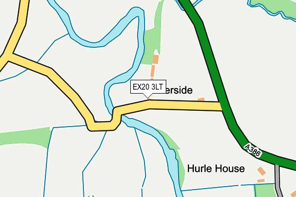
EX20 3LT is located in the Hatherleigh electoral ward, within the local authority district of West Devon and the English Parliamentary constituency of Central Devon. The Sub Integrated Care Board (ICB) Location is NHS Devon ICB - 15N and the police force is Devon & Cornwall. This postcode has been in use since January 1980.


GetTheData
Source: OS OpenMap – Local (Ordnance Survey)
Source: OS VectorMap District (Ordnance Survey)
Licence: Open Government Licence (requires attribution)
| Easting | 254167 |
| Northing | 103639 |
| Latitude | 50.813890 |
| Longitude | -4.071421 |
GetTheData
Source: Open Postcode Geo
Licence: Open Government Licence
| Country | England |
| Postcode District | EX20 |
| ➜ EX20 open data dashboard ➜ See where EX20 is on a map | |
GetTheData
Source: Land Registry Price Paid Data
Licence: Open Government Licence
Elevation or altitude of EX20 3LT as distance above sea level:
| Metres | Feet | |
|---|---|---|
| Elevation | 70m | 230ft |
Elevation is measured from the approximate centre of the postcode, to the nearest point on an OS contour line from OS Terrain 50, which has contour spacing of ten vertical metres.
➜ How high above sea level am I? Find the elevation of your current position using your device's GPS.
GetTheData
Source: Open Postcode Elevation
Licence: Open Government Licence
| Ward | Hatherleigh |
| Constituency | Central Devon |
GetTheData
Source: ONS Postcode Database
Licence: Open Government Licence
| Moor View (A3072) | Hatherleigh | 512m |
| Moor View (A3072) | Hatherleigh | 515m |
| Hatherleigh Bridge (Bridge Street) | Hatherleigh | 549m |
| Co-op (Bridge Street) | Hatherleigh | 681m |
| Market Car Park | Hatherleigh | 723m |
GetTheData
Source: NaPTAN
Licence: Open Government Licence
GetTheData
Source: ONS Postcode Database
Licence: Open Government Licence


➜ Get more ratings from the Food Standards Agency
GetTheData
Source: Food Standards Agency
Licence: FSA terms & conditions
| Last Collection | |||
|---|---|---|---|
| Location | Mon-Fri | Sat | Distance |
| South Street | 15:00 | 09:45 | 613m |
| High Street | 15:15 | 09:45 | 737m |
| Oakfield Road | 15:15 | 09:45 | 1,080m |
GetTheData
Source: Dracos
Licence: Creative Commons Attribution-ShareAlike
| Facility | Distance |
|---|---|
| Hatherleigh Town Football Club Road From Hatherleigh By Pass To Bassets Cross, Hatherleigh Grass Pitches | 107m |
| Hatherleigh Primary School South Street, Hatherleigh, Okehampton Grass Pitches | 585m |
| Hatherleigh Cricket Club Holsworthy Road, Hatherleigh, Okehampton Grass Pitches | 598m |
GetTheData
Source: Active Places
Licence: Open Government Licence
| School | Phase of Education | Distance |
|---|---|---|
| Hatherleigh Community Primary School South Street, Hatherleigh, Okehampton, EX20 3JB | Primary | 583m |
| Northlew and Ashbury Parochial Church of England Primary School Northlew, Okehampton, EX20 3PB | Primary | 5.9km |
GetTheData
Source: Edubase
Licence: Open Government Licence
| Risk of EX20 3LT flooding from rivers and sea | High |
| ➜ EX20 3LT flood map | |
GetTheData
Source: Open Flood Risk by Postcode
Licence: Open Government Licence
The below table lists the International Territorial Level (ITL) codes (formerly Nomenclature of Territorial Units for Statistics (NUTS) codes) and Local Administrative Units (LAU) codes for EX20 3LT:
| ITL 1 Code | Name |
|---|---|
| TLK | South West (England) |
| ITL 2 Code | Name |
| TLK4 | Devon |
| ITL 3 Code | Name |
| TLK43 | Devon CC |
| LAU 1 Code | Name |
| E07000047 | West Devon |
GetTheData
Source: ONS Postcode Directory
Licence: Open Government Licence
The below table lists the Census Output Area (OA), Lower Layer Super Output Area (LSOA), and Middle Layer Super Output Area (MSOA) for EX20 3LT:
| Code | Name | |
|---|---|---|
| OA | E00102950 | |
| LSOA | E01020321 | West Devon 001B |
| MSOA | E02004229 | West Devon 001 |
GetTheData
Source: ONS Postcode Directory
Licence: Open Government Licence
| EX20 3LD | Holsworthy Road | 449m |
| EX20 3DY | Bridge Street | 507m |
| EX20 3JA | Bridge Street | 555m |
| EX20 3LB | Moor View | 578m |
| EX20 3JZ | Cob Meadow | 590m |
| EX20 3JL | Reed Meadow | 591m |
| EX20 3LR | Holsworthy Road | 621m |
| EX20 3QW | Pearse Close | 631m |
| EX20 3DD | Bridge Street | 635m |
| EX20 3GZ | Hawthorn Park | 645m |
GetTheData
Source: Open Postcode Geo; Land Registry Price Paid Data
Licence: Open Government Licence