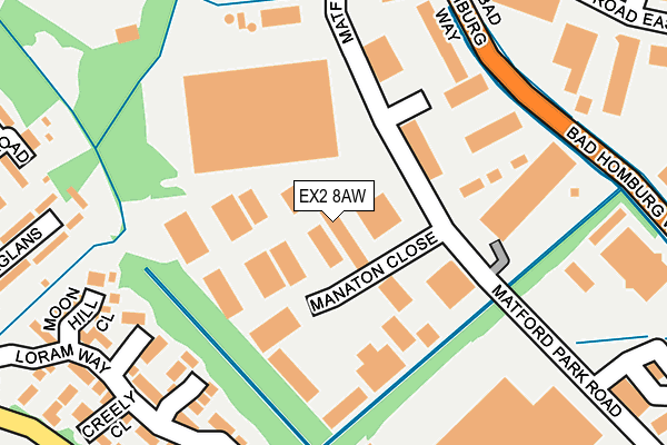
EX2 8AW is located in the Alphington electoral ward, within the local authority district of Exeter and the English Parliamentary constituency of Exeter. The Sub Integrated Care Board (ICB) Location is NHS Devon ICB - 15N and the police force is Devon & Cornwall. This postcode has been in use since September 2015.


GetTheData
Source: OS OpenMap – Local (Ordnance Survey)
Source: OS VectorMap District (Ordnance Survey)
Licence: Open Government Licence (requires attribution)
| Easting | 292408 |
| Northing | 89864 |
| Latitude | 50.698424 |
| Longitude | -3.524828 |
GetTheData
Source: Open Postcode Geo
Licence: Open Government Licence
| Country | England |
| Postcode District | EX2 |
| ➜ EX2 open data dashboard ➜ See where EX2 is on a map ➜ Where is Exeter? | |
GetTheData
Source: Land Registry Price Paid Data
Licence: Open Government Licence
Elevation or altitude of EX2 8AW as distance above sea level:
| Metres | Feet | |
|---|---|---|
| Elevation | 10m | 33ft |
Elevation is measured from the approximate centre of the postcode, to the nearest point on an OS contour line from OS Terrain 50, which has contour spacing of ten vertical metres.
➜ How high above sea level am I? Find the elevation of your current position using your device's GPS.
GetTheData
Source: Open Postcode Elevation
Licence: Open Government Licence
| Ward | Alphington |
| Constituency | Exeter |
GetTheData
Source: ONS Postcode Database
Licence: Open Government Licence
| June 2022 | Violence and sexual offences | On or near Lustleigh Close | 96m |
| June 2022 | Public order | On or near Raglans | 336m |
| June 2022 | Burglary | On or near Bad Homburg Way | 391m |
| ➜ Get more crime data in our Crime section | |||
GetTheData
Source: data.police.uk
Licence: Open Government Licence
| Manaton Close (Matford Park Road) | Marsh Barton | 58m |
| Manaton Close (Matford Park Road) | Marsh Barton | 96m |
| Budlake Road (Matford Park Road) | Marsh Barton | 181m |
| Cofton Road (Hennock Road East) | Marsh Barton | 267m |
| Cofton Road (Hennock Road East) | Marsh Barton | 272m |
| Exeter St Thomas Station | 2.3km |
| Exeter Central Station | 3.2km |
| St James Park (Devon) Station | 3.6km |
GetTheData
Source: NaPTAN
Licence: Open Government Licence
GetTheData
Source: ONS Postcode Database
Licence: Open Government Licence


➜ Get more ratings from the Food Standards Agency
GetTheData
Source: Food Standards Agency
Licence: FSA terms & conditions
| Last Collection | |||
|---|---|---|---|
| Location | Mon-Fri | Sat | Distance |
| Matford Park Road | 19:15 | 12:45 | 171m |
| Matford Park Road | 19:15 | 177m | |
| Grace Road | 19:15 | 12:45 | 783m |
GetTheData
Source: Dracos
Licence: Creative Commons Attribution-ShareAlike
| Facility | Distance |
|---|---|
| Exeter Eagles Bmx Club Cofton Road, Marsh Barton Trading Estate, Exeter Cycling | 585m |
| Exeter Aces Cycle Speedway Club Cofton Road, Marsh Barton Trading Estate, Exeter Cycling | 607m |
| Grace Road Playing Fields (Closed) Alphin Brook Road , Marsh Barton Trading Estate, Exeter Grass Pitches | 684m |
GetTheData
Source: Active Places
Licence: Open Government Licence
| School | Phase of Education | Distance |
|---|---|---|
| Alphington Primary School Wheatsheaf Way, Alphington, Exeter, EX2 8RQ | Primary | 949m |
| Matford Brook Academy March Close, Matford, Exeter, EX2 0BZ | All-through | 1.2km |
| West Exe School Hatherleigh Road, Exeter, EX2 9JU | Secondary | 1.4km |
GetTheData
Source: Edubase
Licence: Open Government Licence
| Risk of EX2 8AW flooding from rivers and sea | Low |
| ➜ EX2 8AW flood map | |
GetTheData
Source: Open Flood Risk by Postcode
Licence: Open Government Licence
The below table lists the International Territorial Level (ITL) codes (formerly Nomenclature of Territorial Units for Statistics (NUTS) codes) and Local Administrative Units (LAU) codes for EX2 8AW:
| ITL 1 Code | Name |
|---|---|
| TLK | South West (England) |
| ITL 2 Code | Name |
| TLK4 | Devon |
| ITL 3 Code | Name |
| TLK43 | Devon CC |
| LAU 1 Code | Name |
| E07000041 | Exeter |
GetTheData
Source: ONS Postcode Directory
Licence: Open Government Licence
The below table lists the Census Output Area (OA), Lower Layer Super Output Area (LSOA), and Middle Layer Super Output Area (MSOA) for EX2 8AW:
| Code | Name | |
|---|---|---|
| OA | E00101076 | |
| LSOA | E01019970 | Exeter 014C |
| MSOA | E02004162 | Exeter 014 |
GetTheData
Source: ONS Postcode Directory
Licence: Open Government Licence
| EX2 8WA | Oaktree Place | 64m |
| EX2 8FD | Matford Park Road | 94m |
| EX2 8PF | Manaton Close | 106m |
| EX2 8PW | Lustleigh Close | 117m |
| EX2 8GB | Three Corner Place | 241m |
| EX2 8GE | Strawberry Avenue | 248m |
| EX2 8GG | Loram Way | 265m |
| EX2 8GA | Moonhill Close | 281m |
| EX2 8GF | Kenbury Drive | 287m |
| EX2 8GD | Creely Close | 327m |
GetTheData
Source: Open Postcode Geo; Land Registry Price Paid Data
Licence: Open Government Licence