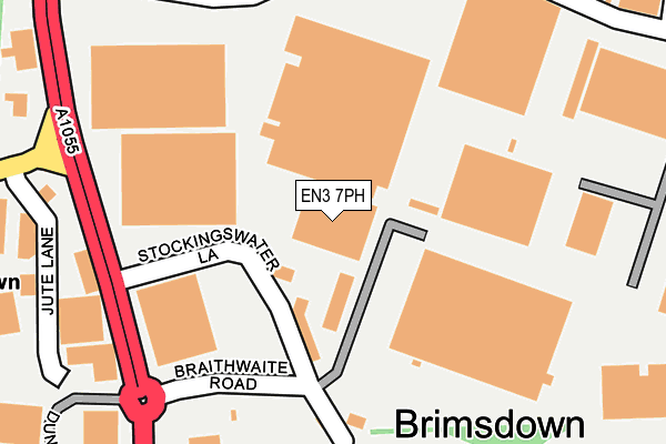
EN3 7PH is located in the Brimsdown electoral ward, within the London borough of Enfield and the English Parliamentary constituency of Enfield North. The Sub Integrated Care Board (ICB) Location is NHS North Central London ICB - 93C and the police force is Metropolitan Police. This postcode has been in use since January 1980.


GetTheData
Source: OS OpenMap – Local (Ordnance Survey)
Source: OS VectorMap District (Ordnance Survey)
Licence: Open Government Licence (requires attribution)
| Easting | 536641 |
| Northing | 197039 |
| Latitude | 51.655539 |
| Longitude | -0.026106 |
GetTheData
Source: Open Postcode Geo
Licence: Open Government Licence
| Country | England |
| Postcode District | EN3 |
| ➜ EN3 open data dashboard ➜ See where EN3 is on a map ➜ Where is London? | |
GetTheData
Source: Land Registry Price Paid Data
Licence: Open Government Licence
Elevation or altitude of EN3 7PH as distance above sea level:
| Metres | Feet | |
|---|---|---|
| Elevation | 20m | 66ft |
Elevation is measured from the approximate centre of the postcode, to the nearest point on an OS contour line from OS Terrain 50, which has contour spacing of ten vertical metres.
➜ How high above sea level am I? Find the elevation of your current position using your device's GPS.
GetTheData
Source: Open Postcode Elevation
Licence: Open Government Licence
| Ward | Brimsdown |
| Constituency | Enfield North |
GetTheData
Source: ONS Postcode Database
Licence: Open Government Licence
| June 2022 | Other theft | On or near Stockingswater Lane | 102m |
| June 2022 | Violence and sexual offences | On or near Braithwaite Road | 172m |
| June 2022 | Public order | On or near Braithwaite Road | 172m |
| ➜ Get more crime data in our Crime section | |||
GetTheData
Source: data.police.uk
Licence: Open Government Licence
| Green Street Brimsdown Stn (Mollison Avenue) | Brimsdown | 201m |
| Jeffreys Road (Mollison Avenue) | Brimsdown | 271m |
| Green Street Brimsdown Stn (Mollison Avenue) | Brimsdown | 308m |
| Brimsdown (Brimsdown Avenue) | Brimsdown | 368m |
| Brimsdown (Green Street) | Brimsdown | 381m |
| Brimsdown Station | 0.3km |
| Ponders End Station | 1.6km |
| Enfield Lock Station | 1.7km |
GetTheData
Source: NaPTAN
Licence: Open Government Licence
GetTheData
Source: ONS Postcode Database
Licence: Open Government Licence


➜ Get more ratings from the Food Standards Agency
GetTheData
Source: Food Standards Agency
Licence: FSA terms & conditions
| Last Collection | |||
|---|---|---|---|
| Location | Mon-Fri | Sat | Distance |
| Green Street Postoffice | 18:30 | 12:00 | 370m |
| Avondale Crescent | 18:30 | 12:00 | 749m |
| Brimsdown Avenue | 17:30 | 12:00 | 926m |
GetTheData
Source: Dracos
Licence: Creative Commons Attribution-ShareAlike
| Facility | Distance |
|---|---|
| Muscle Limit Lockfield Avenue, Enfield Health and Fitness Gym | 359m |
| Brimsdown Primary School Green Street, Enfield Grass Pitches | 742m |
| Brimsdown Sports And Social Club (Closed) Goldsdown Road, Enfield Grass Pitches | 751m |
GetTheData
Source: Active Places
Licence: Open Government Licence
| School | Phase of Education | Distance |
|---|---|---|
| Brimsdown Primary School Green Street, Enfield, EN3 7NA | Primary | 631m |
| St Mary's Catholic Primary School Durants Road, Ponders End, Enfield, EN3 7DE | Primary | 1.2km |
| Kingfisher Hall Primary Academy 40 The Ride, Enfield, EN3 7GB | Primary | 1.3km |
GetTheData
Source: Edubase
Licence: Open Government Licence
| Risk of EN3 7PH flooding from rivers and sea | Low |
| ➜ EN3 7PH flood map | |
GetTheData
Source: Open Flood Risk by Postcode
Licence: Open Government Licence
The below table lists the International Territorial Level (ITL) codes (formerly Nomenclature of Territorial Units for Statistics (NUTS) codes) and Local Administrative Units (LAU) codes for EN3 7PH:
| ITL 1 Code | Name |
|---|---|
| TLI | London |
| ITL 2 Code | Name |
| TLI5 | Outer London - East and North East |
| ITL 3 Code | Name |
| TLI54 | Enfield |
| LAU 1 Code | Name |
| E09000010 | Enfield |
GetTheData
Source: ONS Postcode Directory
Licence: Open Government Licence
The below table lists the Census Output Area (OA), Lower Layer Super Output Area (LSOA), and Middle Layer Super Output Area (MSOA) for EN3 7PH:
| Code | Name | |
|---|---|---|
| OA | E00007127 | |
| LSOA | E01001437 | Enfield 014A |
| MSOA | E02000290 | Enfield 014 |
GetTheData
Source: ONS Postcode Directory
Licence: Open Government Licence
| EN3 7JX | Stockingswater Lane | 81m |
| EN3 7PJ | Jute Lane | 281m |
| EN3 7JY | Lockfield Avenue | 361m |
| EN3 7SH | Green Street | 376m |
| EN3 7BJ | Leaside Business Centre | 378m |
| EN3 5EN | Brimsdown Avenue | 392m |
| EN3 7DW | Millmarsh Lane | 416m |
| EN3 5EW | Brimsdown Avenue | 421m |
| EN3 7TQ | Enstone Road | 425m |
| EN3 7SB | Green Street | 450m |
GetTheData
Source: Open Postcode Geo; Land Registry Price Paid Data
Licence: Open Government Licence