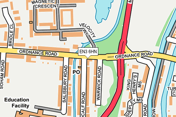
EN3 6HN lies on Ordnance Road in Enfield. EN3 6HN is located in the Enfield Lock electoral ward, within the London borough of Enfield and the English Parliamentary constituency of Enfield North. The Sub Integrated Care Board (ICB) Location is NHS North Central London ICB - 93C and the police force is Metropolitan Police. This postcode has been in use since January 1980.


GetTheData
Source: OS OpenMap – Local (Ordnance Survey)
Source: OS VectorMap District (Ordnance Survey)
Licence: Open Government Licence (requires attribution)
| Easting | 536942 |
| Northing | 198736 |
| Latitude | 51.670714 |
| Longitude | -0.021093 |
GetTheData
Source: Open Postcode Geo
Licence: Open Government Licence
| Street | Ordnance Road |
| Town/City | Enfield |
| Country | England |
| Postcode District | EN3 |
| ➜ EN3 open data dashboard ➜ See where EN3 is on a map ➜ Where is London? | |
GetTheData
Source: Land Registry Price Paid Data
Licence: Open Government Licence
Elevation or altitude of EN3 6HN as distance above sea level:
| Metres | Feet | |
|---|---|---|
| Elevation | 20m | 66ft |
Elevation is measured from the approximate centre of the postcode, to the nearest point on an OS contour line from OS Terrain 50, which has contour spacing of ten vertical metres.
➜ How high above sea level am I? Find the elevation of your current position using your device's GPS.
GetTheData
Source: Open Postcode Elevation
Licence: Open Government Licence
| Ward | Enfield Lock |
| Constituency | Enfield North |
GetTheData
Source: ONS Postcode Database
Licence: Open Government Licence
| December 2023 | Other theft | On or near Park/Open Space | 238m |
| December 2023 | Public order | On or near Park/Open Space | 238m |
| December 2023 | Anti-social behaviour | On or near Park/Open Space | 238m |
| ➜ Ordnance Road crime map and outcomes | |||
GetTheData
Source: data.police.uk
Licence: Open Government Licence
| Ordnance Road Mollison Avenue (Ordnance Road) | Enfield Lock | 67m |
| Mollison Avenue (Ordnance Road) | Enfield Lock | 130m |
| Causeway Bridge River Lee (Smeaton Road) | Enfield Lock | 215m |
| Causeway Bridge River Lee (Smeaton Road) | Enfield Lock | 233m |
| Gunner Drive | Enfield Lock | 390m |
| Enfield Lock Station | 0.5km |
| Waltham Cross Station | 1.6km |
| Brimsdown Station | 1.8km |
GetTheData
Source: NaPTAN
Licence: Open Government Licence
GetTheData
Source: ONS Postcode Database
Licence: Open Government Licence


➜ Get more ratings from the Food Standards Agency
GetTheData
Source: Food Standards Agency
Licence: FSA terms & conditions
| Last Collection | |||
|---|---|---|---|
| Location | Mon-Fri | Sat | Distance |
| Enfield Lock Station | 17:30 | 12:00 | 37m |
| Somerset Road | 17:30 | 12:00 | 343m |
| Enfield Lock | 17:30 | 12:00 | 490m |
GetTheData
Source: Dracos
Licence: Creative Commons Attribution-ShareAlike
| Facility | Distance |
|---|---|
| Soham Road Recreation Ground Salisbury Road, Enfield Grass Pitches | 286m |
| Oasis Academy Enfield Kinetic Crescent, Enfield Artificial Grass Pitch, Sports Hall | 322m |
| Muscleworks Gym Enfield Island Centre Way, Enfield Health and Fitness Gym, Studio | 431m |
GetTheData
Source: Active Places
Licence: Open Government Licence
| School | Phase of Education | Distance |
|---|---|---|
| Prince of Wales Primary School Salisbury Road, Enfield, EN3 6HG | Primary | 259m |
| Oasis Academy Enfield Kinetic Crescent, Innova Park, Enfield, EN3 7XH | Secondary | 312m |
| Freshsteps Independent school Innova House, Kenetic Crescent, Enfield, Brimsdown, EN3 7XH | Not applicable | 323m |
GetTheData
Source: Edubase
Licence: Open Government Licence
| Risk of EN3 6HN flooding from rivers and sea | Medium |
| ➜ EN3 6HN flood map | |
GetTheData
Source: Open Flood Risk by Postcode
Licence: Open Government Licence
The below table lists the International Territorial Level (ITL) codes (formerly Nomenclature of Territorial Units for Statistics (NUTS) codes) and Local Administrative Units (LAU) codes for EN3 6HN:
| ITL 1 Code | Name |
|---|---|
| TLI | London |
| ITL 2 Code | Name |
| TLI5 | Outer London - East and North East |
| ITL 3 Code | Name |
| TLI54 | Enfield |
| LAU 1 Code | Name |
| E09000010 | Enfield |
GetTheData
Source: ONS Postcode Directory
Licence: Open Government Licence
The below table lists the Census Output Area (OA), Lower Layer Super Output Area (LSOA), and Middle Layer Super Output Area (MSOA) for EN3 6HN:
| Code | Name | |
|---|---|---|
| OA | E00171150 | |
| LSOA | E01001445 | Enfield 003B |
| MSOA | E02000279 | Enfield 003 |
GetTheData
Source: ONS Postcode Directory
Licence: Open Government Licence
| EN3 6HH | Ordnance Road | 59m |
| EN3 6HW | Warwick Road | 80m |
| EN3 7FE | Velocity Way | 93m |
| EN3 6HL | Medcalf Road | 105m |
| EN3 7FG | Velocity Way | 107m |
| EN3 6HJ | Medcalf Road | 117m |
| EN3 6HF | Ordnance Road | 123m |
| EN3 6HQ | Salisbury Road | 137m |
| EN3 6HG | Salisbury Road | 142m |
| EN3 6JS | King Henrys Mews | 154m |
GetTheData
Source: Open Postcode Geo; Land Registry Price Paid Data
Licence: Open Government Licence